
Monday Morning’s Weather Briefing — October 19, 2026

Good Monday Morning!
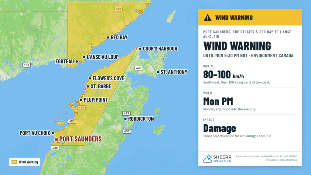
- A wind warning is in effect for Port Saunders and the Straits, and for Red Bay to L’Anse-au-Clair, from this afternoon until this evening, with southwesterly gusts of 80 km/h, and near 100 along parts of the coast.
- It’s a frosty start, with temperatures below freezing across most of the province: -2 to -6 on the Island and near -8 to -9 in central and western Labrador, with wind chills down to -18.
- Plenty of sunshine on the Island today, with highs of 7 to 10 and southwest winds gusting to 50 or 60 km/h by midday.
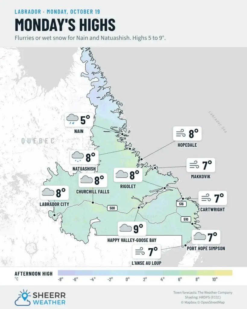
- In Labrador, flurries change to rain showers today, with about 2 cm of snow for Nain this morning.
- Showers move into eastern Newfoundland on Tuesday as a system develops off the U.S. East Coast, with mild highs near 12.
It was as cold a night as advertised. Clear skies and light winds let temperatures drop below the freezing mark for most of the province, and you’ll likely find frost on the windshield this morning. Lows were in the -2 to -6 range on the Island, coldest in the low-lying spots of central Newfoundland and inland on the West Coast, and down to around -8 or -9 in Goose Bay, Churchill Falls and Lab West, with wind chills of -15 to -18. Give yourself a few extra minutes to clear off the car, and watch for slick spots on bridges and overpasses early this morning.
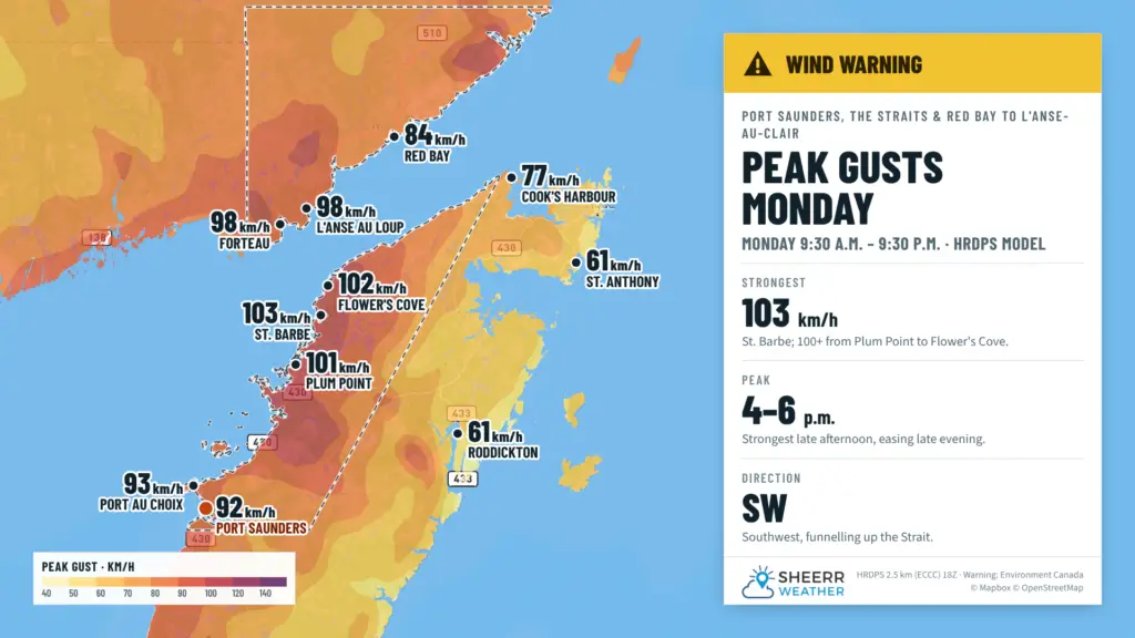
The good news is that today is a nice one on the Island. Sunshine wins out for most of Newfoundland, and with southwest winds bringing in milder air, highs reach 7 to 10 this afternoon. Those southwest winds pick up near noon, gusting to 50 or 60 km/h for many areas, and a lot stronger on the Northern Peninsula. Environment Canada has issued a wind warning for Port Saunders and the Straits, and for Red Bay to L’Anse-au-Clair, with maximum southwesterly gusts of 80 km/h, except near 100 along parts of the coast, from this afternoon until this evening. Secure loose objects and be prepared for possible disruptions to transportation, services and utilities. The Labrador Straits were added to the warning early this morning, with gusts near 98 km/h expected at Forteau and L’Anse au Loup.
Labrador doesn’t get as much sunshine. Clouds roll in this morning, and the flurries that start the day in western and central Labrador change to rain showers as temperatures climb to 7 to 9 this afternoon. On the North Coast, snow this morning brings about 2 cm to Nain before it changes to rain showers this afternoon. Tonight is much milder everywhere, with temperatures holding steady or rising overnight across much of the Island.
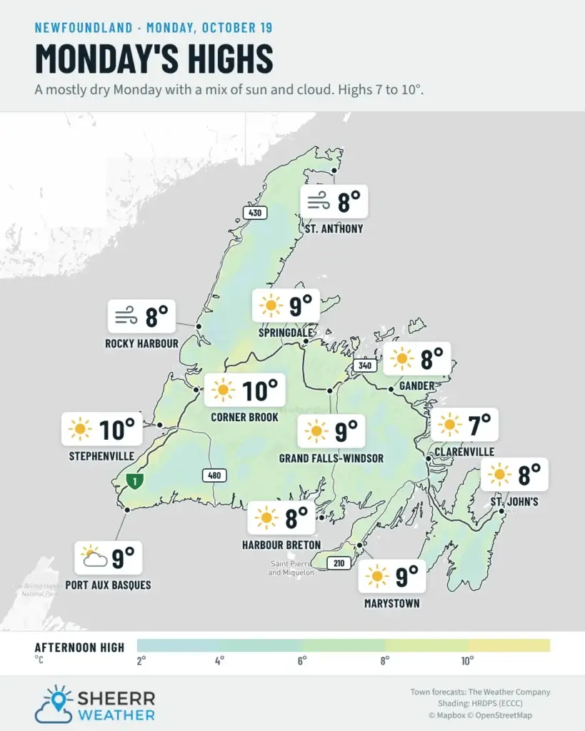
Eastern Newfoundland / the Avalon: A frosty start, then sunny. Highs near 7. Light winds this morning become southwest 30 km/h, gusting to 50, this afternoon. Clear this evening, with clouds increasing overnight. Lows of 2 to 4, with temperatures rising toward 9 by morning on the Avalon. Showers on Tuesday, with a high of 12.
Central: Sunny after a cold start, with wind chills near -6 early. Highs 8 to 9. Southwest winds 30 km/h, gusting to 50, near noon. Clear this evening, then partly cloudy overnight, with lows near +4 and temperatures rising by morning. Cloudy and mild Tuesday, with highs of 11 to 12.
West Coast: Sunny, with highs near 10. Winds become south 20 km/h, then southwest 40 gusting to 60 near noon. Clouds move in near midnight, and winds ease overnight. Lows near +5. Tuesday is cloudy, with a 40 percent chance of showers and a high of 11.
South Coast: Sunny on the Burin Peninsula, and a mix of sun and cloud toward Burgeo. Highs 8 to 10. Southwest winds 20 to 30 km/h, gusting to 40 or 50. Clouds increase tonight, with temperatures holding steady near 8 toward Burgeo and rising to 8 by morning on the Burin. Tuesday is cloudy, with a 40 percent chance of showers and highs of 10 to 12.
Southwest / Wreckhouse: Mainly sunny, with a high near 10 in Port aux Basques. South winds 30 km/h, gusting to 50, this morning. Clouds increase tonight, with winds turning southwest 20 km/h after midnight and a mild low near 7. No warning-level gusts are expected through Wreckhouse, but you can always check the Wreckhouse Wind Gauge before you travel. Tuesday is cloudy, with a 40 percent chance of showers and a high near 10.
GNP and the Straits: A wind warning is in effect for Port Saunders and the Straits, and for Red Bay to L’Anse-au-Clair, from this afternoon until this evening, with southwesterly gusts of 80 km/h, and near 100 along parts of the coast. Mainly sunny this morning, with clouds increasing this afternoon. Highs 7 to 9. Southwest winds increase to 60 km/h, gusting to 80, around noon along the west side of the Peninsula. The strongest gusts, over 100 km/h, are expected from Plum Point to Flower’s Cove, peaking between 4 and 6 this afternoon before easing late this evening. A 40 percent chance of showers tonight, with temperatures steady near 7 to 9 and winds easing overnight. Tuesday is cloudy, with a 40 percent chance of showers and a high near 8.
Labrador / the Big Land: A very cold start, with wind chills of -13 to -18 this morning. In Lab West, flurries change to rain showers this morning, with a high near 7 and southwest winds gusting to 50. Churchill Falls sees a few flurries this morning, then a 60 percent chance of rain showers, with a high near 9. Goose Bay is cloudy, with a few flurries or rain showers starting this morning, southwest winds gusting to 60, and a high near 8. Along the southeast coast, clouds increase, with a 60 percent chance of flurries or rain showers this afternoon and a high near 7. Southwest winds gust to 60. A wind warning is in effect for Red Bay to L’Anse-au-Clair from this afternoon until this evening, with southwesterly gusts of 80 km/h, and near 100 along parts of the coast. On the North Coast, snow this morning, with about 2 cm in Nain, then rain showers this afternoon and highs of 7 to 8. Tonight, Lab West’s showers change back to flurries, with lows near 0 to +5. Tuesday brings flurries or rain showers, with highs of 2 to 4 in the north and west, and near 8 in the southeast.
Looking ahead: That system developing off the U.S. East Coast brings showers to eastern Newfoundland on Tuesday. It doesn’t look like a big rain-maker, just a few showers on and off through the day, and it will be mild, with highs of 11 to 12 for much of the Island. Elsewhere, there’s a 40 percent chance of showers. Labrador stays cool, with flurries or rain showers. Cooler, quieter weather settles in Wednesday, with highs of 6 to 10 and clouds mixing with some sun.
📱 Get the Sheerr Weather App in the Apple App Store and Google Play Store.
📍 Want more detail for where you live? Check out our new Regional Forecast pages for current conditions, local alerts, highway cams and the forecast for your area: Avalon · Eastern · Burin Peninsula · South Coast · West Coast · Long Range Mountains · Central · GNP & the Straits · Labrador West · Central Labrador · Labrador North Coast · Labrador South Coast
🗺️ Check out the Map Room to see all the latest weather observations for the Province.
🎥 Check out the Provincial Highway Cams to see 👀 what’s going on around our highways.
why is the glass so high today Oct 19. ???
There is a high-pressure area directly over eastern Newfoundland this morning 🙂