
Friday Morning’s Weather Briefing — October 16, 2026
Good Friday Morning!
- A wind warning remains in effect until this morning for the Bonavista Peninsula, Bonavista North and the Bay of Exploits, with northwesterly gusts up to 110 km/h.
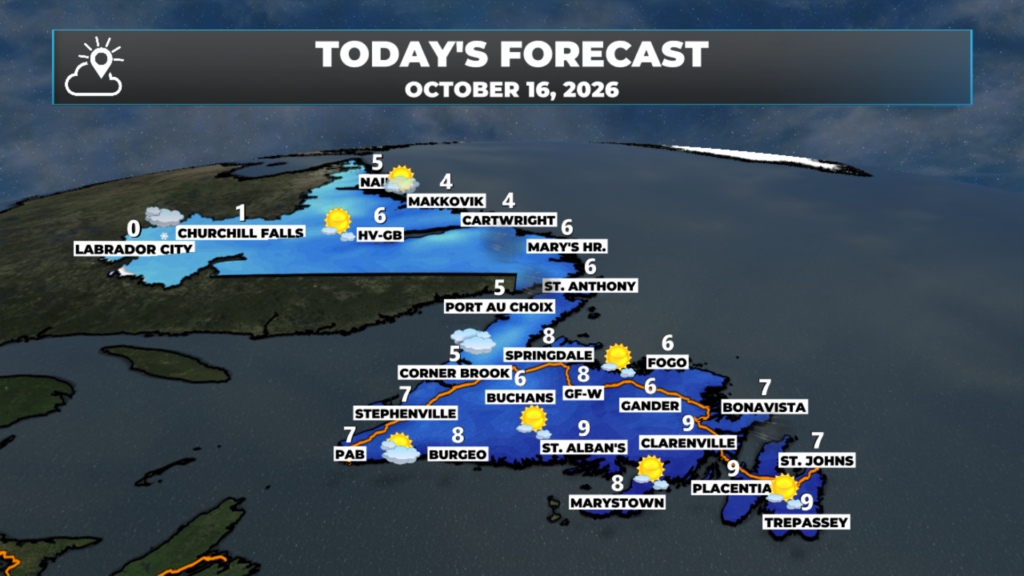
- It’s a cooler start, with temperatures near freezing across much of Newfoundland and below freezing in Labrador.
- Skies clear for a decent day on the Island, with highs of 5 to 9, before clouds roll back in this afternoon and evening.
- Snow moves into Lab West this evening, and rain returns to Newfoundland after midnight.
- Saturday brings rain, wind gusts of 80 to 100 km/h on the Island, and heavy, wet snow for parts of southeastern Labrador.
Yesterday’s storm is pulling away, and it’s leaving a breezy, cooler start to Friday behind it. Northwesterly winds are still gusty this morning, and Environment Canada’s wind warning remains in effect until this morning for the Bonavista Peninsula, Bonavista North and the Bay of Exploits. Strong winds are expected or occurring, especially near the coast, with maximum northwesterly gusts of 110 km/h, so be prepared to adapt your driving for changing conditions. Those winds ease through the day.
Temperatures are near freezing across much of the Island to start the day, and a few degrees below the freezing mark in Labrador, down to around -6 in Lab West. If your car’s been sitting out overnight, give yourself a few extra minutes to clear the windshield.
Today is the break between storms. Leftover clouds and drizzle clear out this morning, and most of Newfoundland sees a mix of sun and cloud this afternoon, with highs of 5 to 9. It won’t last into the weekend, though. Clouds roll back in later today as our next area of low pressure approaches, with snow spreading into western Labrador this evening and rain returning to the Island after midnight.
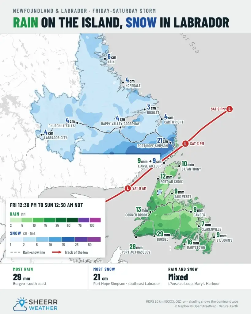
Snow for southeastern Labrador on Saturday: Environment Canada has issued a special weather statement for Eagle River, Cartwright to Black Tickle, Norman Bay to Lodge Bay, and Red Bay to L’Anse-au-Clair. The first notable snowfall of the season is expected Saturday, with near 10 cm inland and over higher terrain. The snow is expected to be wet and heavy, and roads could become slippery and difficult to navigate.
This morning’s update is sponsored by Roebothan, McKay, Marshall.
Visit MakeTheCall.ca today to learn more about how the law firm can help you!
Eastern Newfoundland / the Avalon: Mostly cloudy and windy this morning, becoming partly cloudy this afternoon. Highs 8 to 9. West-northwest winds 30 to 50 km/h, gusting over 65 at times. A wind warning is in effect until this morning for the Bonavista Peninsula, with northwesterly gusts up to 110 km/h, before the winds ease. Cloudy tonight, with rain arriving toward morning and lows near 4 to 6.
Central: Cloudy and windy around Gander this morning, then a mix of sun and cloud. A wind warning is in effect until this morning for Bonavista North and the Bay of Exploits, with northwesterly gusts up to 110 km/h. Highs 6 to 9. West-northwest winds 30 to 50 km/h near Gander and the Northeast Coast, lighter farther inland. Rain develops after midnight, with lows of 1 to 3.
West Coast: A cool, mostly cloudy day, with highs of 5 in Corner Brook and Gros Morne, 6 in Stephenville and 7 in Deer Lake. Light northwest winds. Rain moves in after midnight, with about 6 mm by morning and lows of 2 to 4.
South Coast: The best of the weather today, with plenty of sun this morning and some clouds this afternoon. Highs near 9. West-northwest winds 15 to 40 km/h. Rain returns after midnight, becoming steady and soaking along the coast toward Burgeo, with southwest winds picking up. Lows of 5 to 6.
Southwest / Wreckhouse: A mix of sun and cloud early, then cloudy this afternoon, with a high near 7 in Port aux Basques. Northwest winds 25 to 40 km/h ease today. Rain moves in tonight, with about 12 mm by morning, and southeasterly winds increase late. With winds turning southeast ahead of this next low, keep an eye on the Wreckhouse Wind Gauge if you’re travelling tonight or Saturday.
GNP and the Straits: Partly cloudy and breezy, with highs of 5 to 6. Northwest winds 30 to 50 km/h, gusting over 65 this morning before diminishing this afternoon. Rain develops after midnight, with lows of 2 to 3.
Labrador: Lab West is cloudy, with snow showers developing this afternoon, a high near 0, and 2 to 3 cm possible tonight. Churchill Falls is cloudy, with a high near 1 and snow showers tonight. Goose Bay starts sunny, then clouds over, with a high near 6 and light snow possible after midnight. On the South Coast, cloudy and windy this morning, then partly cloudy, with highs of 4 to 6 and northwest winds gusting over 65. The North Coast is sunny, with a high near 5 in Nain. Lows tonight range from -1 to -4.
Looking ahead: Our next storm arrives tonight and peaks Saturday. Across Newfoundland, look for 5 to 15 mm of rain for most areas, 15 to 25 mm for parts of the West Coast, and over 25 mm along the South Coast in places like Burgeo and Port aux Basques. Saturday will be mild in the east, with highs of 15 to 17, and windy, with many areas seeing gusts of 80 to 100 km/h between tonight and Saturday afternoon, so more wind warnings are likely. In southeastern Labrador, the snow may not change to rain for many areas. Right now, I’m expecting 15 to 20 cm from Mary’s Harbour to Port Hope Simpson and Charlottetown, with lesser amounts north and south of there and right along the Straits, and about 5 cm for Goose Bay, North West River and Rigolet. Things wind down by Sunday morning, and Sunday and next week look quieter, with cool temperatures and some sunshine.
📱 Get the Sheerr Weather App in the Apple App Store and Google Play Store.
🗺️ Check out the Map Room to see all the latest weather observations for the Province.
🎥 Check out the Provincial Highway Cams to see 👀 what’s going on around our highways.