
Sunday Morning’s Weather Briefing — October 18, 2026
Good Sunday Morning!
- Rain showers and flurries move through today with an upper-level system, mainly for western and central Newfoundland and parts of Labrador.
- It’s a breezy day too, with northwest winds gusting 50 to 70 km/h at times.
- A very cold night is ahead across much of the province, with lows of -2 to -6 on the Island and -8 to -9 in central and western Labrador. Wind chills dip into the minus teens in Labrador.
- Monday is sunny and milder on the Island, while more rain showers and flurries move through Labrador.
- A system developing off the east coast of the U.S. may bring some rain to eastern Newfoundland on Tuesday.
After yesterday’s storm, we’re into a cooler, showery pattern to wrap up the weekend. An upper-level system is swinging across the province today, and it’s bringing a mix of rain showers and flurries along with it. The best chance of seeing them is on the West Coast, through central Newfoundland and over parts of Labrador, where it’s cold enough that some of what falls will be white, especially over higher terrain and in Labrador. Amounts look light, generally a centimetre or less, but don’t be surprised by a quick burst of wet flakes on the windshield.
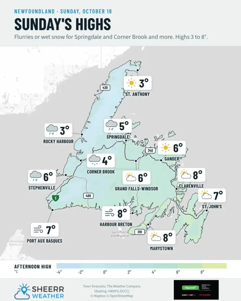
It’s a breezy day as well. Northwest winds pick up this morning, with gusts of 50 to 60 km/h for many areas around midday and up to 70 km/h on the Northern Peninsula and in parts of Labrador. Highs are cool for mid-October, from 2 to 8 on the Island and near the freezing mark in western Labrador.
Tonight is the big story. Skies clear out this evening, the winds go light, and temperatures drop fast. Most of the Island falls below the freezing mark, with lows of -2 to -6, and the coldest readings in the low-lying spots of central Newfoundland and inland on the West Coast. In Labrador, Goose Bay drops to about -8 and Lab West and Churchill Falls to about -9, with wind chills of -15 to -18 overnight. If your car’s parked outside, give yourself a few extra minutes Monday morning to scrape off the frost, and watch for slick spots on bridges and overpasses.
This morning’s update is sponsored by Roebothan, McKay, Marshall.
Visit MakeTheCall.ca today to learn more about how the law firm can help you!
Eastern Newfoundland / the Avalon: Cloudy this morning, then a mix of sun and cloud. Highs 6 to 7. Northwest winds 30 km/h, gusting to 50 around midday. There’s a chance of a rain shower or flurry this evening on the Bonavista Peninsula and around Clarenville. Clearing tonight, with lows near 0 on the Avalon and -2 farther north and west, and wind chills near -8 overnight. Monday is sunny, with highs of 7 to 8.
Central: A mix of sun and cloud, with a 60 percent chance of rain showers or flurries this afternoon. Highs near 6, and closer to 4 toward Buchans. West winds 40 km/h, gusting to 60 around midday. Showers end this evening, then clearing and cold overnight, with lows of -2 and as low as -6 in low-lying areas. Monday is sunny, with highs of 7 to 9.
West Coast: Rain showers and flurries on and off today, with highs near 4, and up to 6 toward Stephenville. Northwest winds 40 km/h, gusting to 60. The showers wrap up this evening, then it clears out, with lows near 0 along the coast and -4 to -5 inland around Deer Lake. Monday is sunny and milder, with highs of 9 to 10.
South Coast: A mix of sun and cloud, with a chance of a rain shower or flurry, mainly this morning on the Burin Peninsula and through the day toward Burgeo. Highs 7 to 8. West winds 40 km/h, gusting to 60 around midday. Clearing tonight, with lows near 0 to +2 along the coast, and -3 to -6 inland. Monday is sunny, with highs of 8 to 10.
Southwest / Wreckhouse: Mainly cloudy, with a 60 percent chance of flurries or rain showers this morning and early this afternoon. High near 6 in Port aux Basques. Northwest winds 30 km/h, gusting to 50, becoming west 40 gusting to 60 around noon. Clearing near midnight, with winds going light and a low near +2. Monday is mainly sunny, with south winds 30 km/h gusting to 50 and a high near 10.
GNP and the Straits: A mix of sun and cloud, with a 60 percent chance of flurries late this morning and this afternoon. Highs 2 to 3. Northwest winds increase to 50 km/h, gusting to 70, this afternoon. Flurries end early this evening, and lows are near 0. Monday starts sunny before clouds move in. Southwest winds pick up near noon, gusting to 70 or 80 along the west side of the Peninsula. Highs 7 to 8.
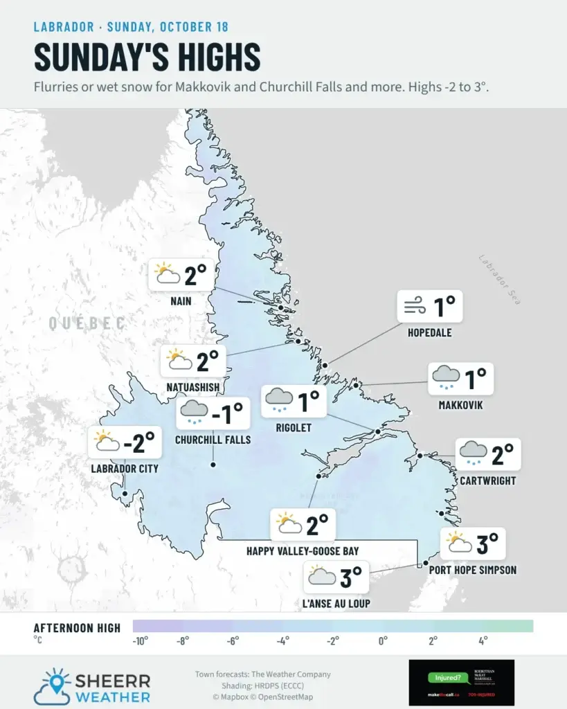
Labrador / the Big Land: Flurries end this morning in Lab West, then skies clear. The high is near 0, and northwest winds gust to 70 this morning before easing. Churchill Falls is mainly cloudy, with a few flurries this morning and a high near 0. Goose Bay sees a mix of sun and cloud, with a 40 percent chance of flurries and a high near +1. Along the coast, it’s mainly sunny this morning, with a few flurries later today and highs of 0 to 3. Northwest winds gust to 80 along parts of the North Coast this afternoon. Tonight is cold, with lows of -8 to -9 in Goose Bay, Churchill Falls and Lab West, and wind chills of -15 to -18. More rain showers and flurries move through Monday, with about 2 cm of snow for Nain.
Looking ahead: Monday looks like the pick of the next few days on the Island, with sunshine, highs of 7 to 10, and southwest winds picking up in the afternoon. Labrador gets another round of flurries changing to rain showers. On Tuesday, a system developing off the east coast of the U.S. may bring some rain to eastern Newfoundland. Right now, it looks like a few showers rather than a soaker, but I’ll keep an eye on the track. It will be mild Tuesday, with highs of 11 to 13 for much of the Island, before cooler, quieter weather returns Wednesday.
📱 Get the Sheerr Weather App in the Apple App Store and Google Play Store.
📍 Want more detail for where you live? Check out our new Regional Forecast pages for current conditions, local alerts, highway cams and the forecast for your area: Avalon · Eastern · Burin Peninsula · South Coast · West Coast · Long Range Mountains · Central · GNP & the Straits · Labrador West · Central Labrador · Labrador North Coast · Labrador South Coast
🗺️ Check out the Map Room to see all the latest weather observations for the Province.
🎥 Check out the Provincial Highway Cams to see 👀 what’s going on around our highways.