
Tuesday Morning’s Weather Briefing — October 20, 2026
Good Tuesday Morning!
- A quiet, mild day across Newfoundland, with a mix of sun and cloud and highs of 9 to 14.
- Yesterday’s gusty southwest winds have eased, and winds go light for many areas by midday.
- A few showers are possible on the Avalon this afternoon and on the Burin Peninsula this morning, but most of the Island stays dry.
- Skies clear on the West Coast late this afternoon.
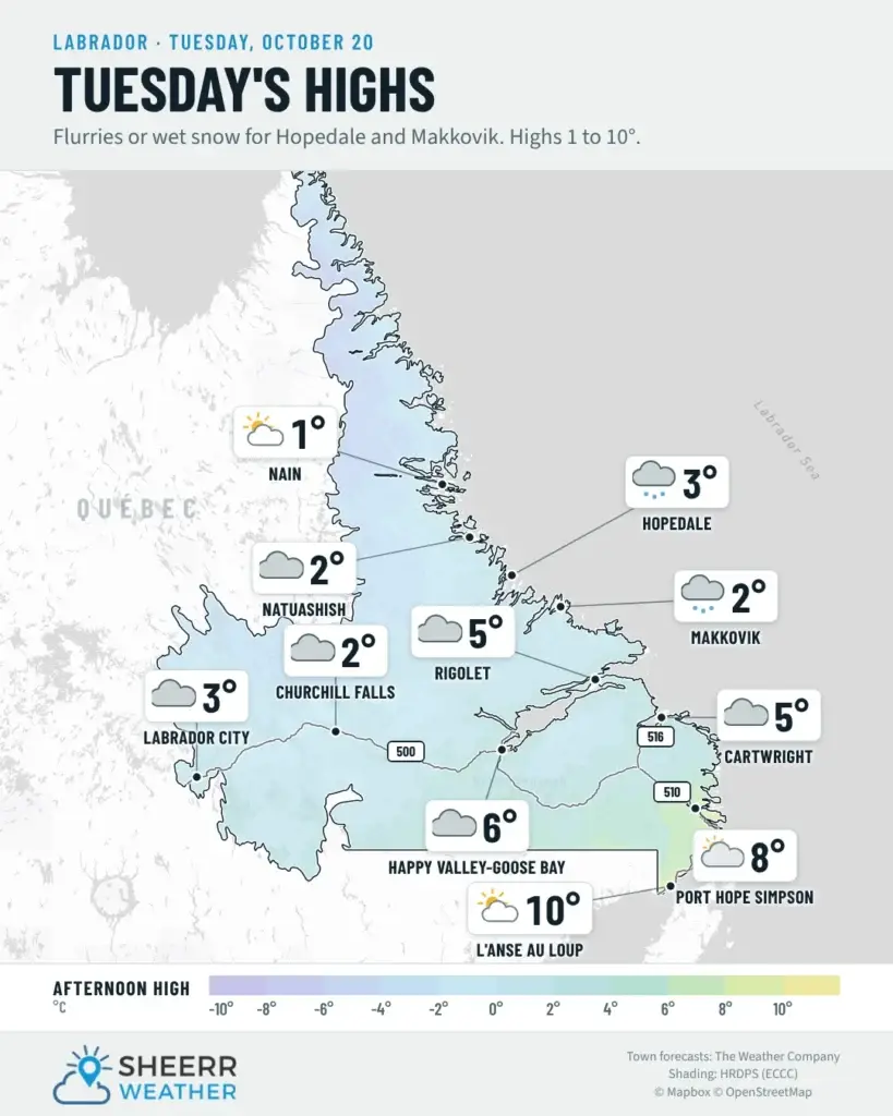
- Labrador is cooler, with highs of 1 to 10 and a chance of flurries or rain showers.
- Cooler air arrives on Wednesday, with northeast winds and highs of 6 to 10.
After yesterday’s wind on the Northern Peninsula and in southern Labrador, things settle down nicely today. The southwest winds that brought gusts near 100 km/h to the Straits have eased overnight, and the warnings have ended. It’s a much milder start than yesterday too. Temperatures rose overnight across much of the Island and are sitting around 6 to 9 this morning, so no frost to scrape off the windshield today.
It’s a quiet day for most of Newfoundland. Expect plenty of cloud, but it will be mild, with highs of 11 to 14 for most areas, and closer to 9 on the Northern Peninsula. Winds are southwest 20 km/h, gusting to 40, this morning and go light for many areas by midday. Most places stay dry. There’s a 40 percent chance of showers on the Avalon this afternoon and a chance of a few showers or some drizzle on the Burin Peninsula this morning, but nothing heavy. On the West Coast, skies clear late this afternoon.
Labrador is cooler and cloudier. There’s a chance of flurries or rain showers, with temperatures near 2 to 3 in the west, steady near 6 in Goose Bay, and falling through the afternoon along the southeast coast. On the North Coast, flurries end this morning in Nain, while Hopedale and Makkovik could see flurries or wet snow through the day.
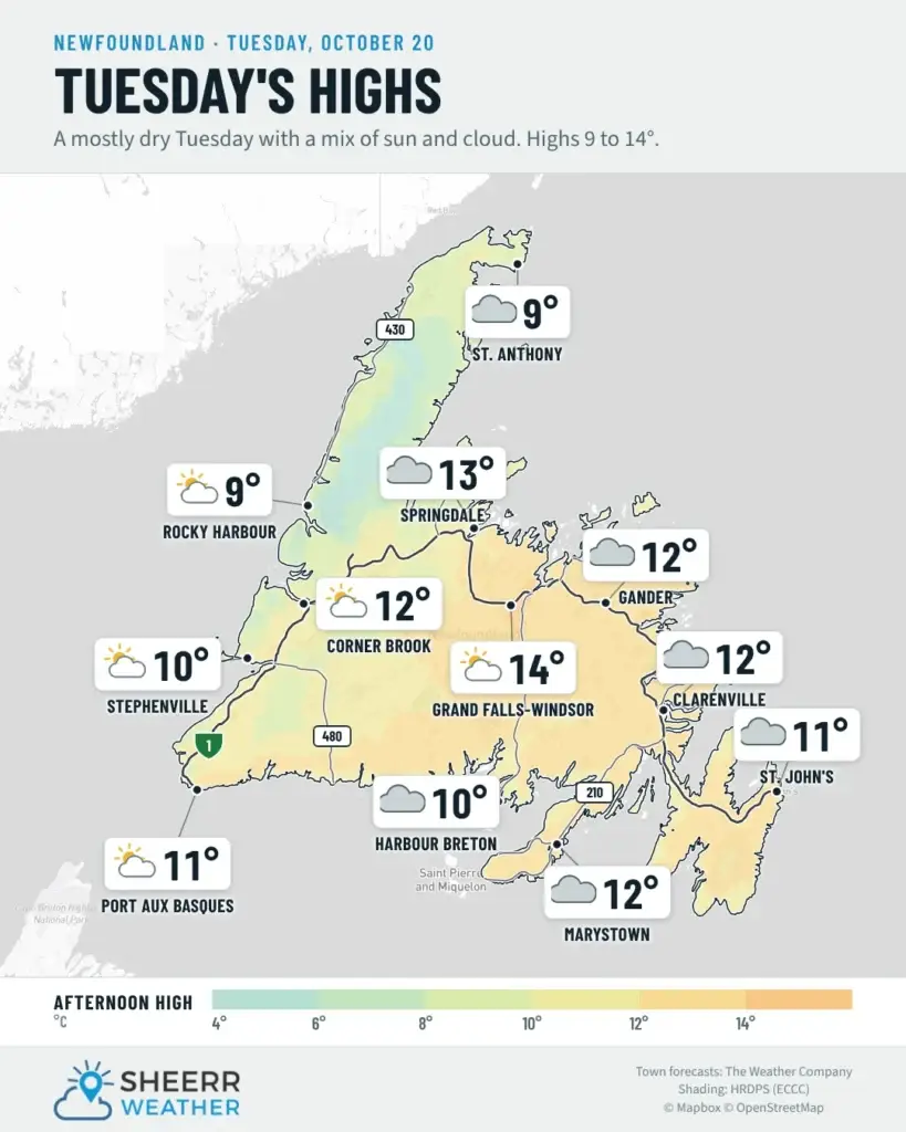
Eastern Newfoundland / the Avalon: Mainly cloudy and mild, with highs of 12. A 40 percent chance of showers on the Avalon this afternoon. Southwest winds 20 km/h, gusting to 40, becoming light this afternoon. Mainly cloudy tonight, with winds turning northeast near midnight. Lows of 2 to 4.
Central: Mainly cloudy, with highs of 12 to 14, mildest in the Exploits Valley. Southwest winds 20 km/h, gusting to 40, becoming west 20 this afternoon. Mainly cloudy tonight, with winds turning northeast near midnight. Lows near 0 to 2.
West Coast: Mainly cloudy, then clearing late this afternoon. Highs 10 to 12. Southwest winds 20 km/h, gusting to 40, going light this morning. Clear this evening, then partly cloudy, with a 40 percent chance of showers overnight. Lows near +2 along the coast, and near -1 around Deer Lake.
South Coast: Mainly cloudy, with a 40 percent chance of showers or drizzle on the Burin Peninsula this morning. Highs 11 to 12. Winds become light near noon. Clearing late this afternoon toward Burgeo. Lows of 3 tonight, with northeast winds 20 km/h, gusting to 40, picking up late this evening.
Southwest / Wreckhouse: Mainly cloudy, clearing late this afternoon, with a high near 11 in Port aux Basques. West winds 20 km/h, gusting to 40, go light near noon. Clear tonight, with north winds 20 km/h and a low near +2. No strong winds are expected through Wreckhouse, but you can always check the Wreckhouse Wind Gauge before you travel.
GNP and the Straits: A mix of sun and cloud after a windy night. Southwest winds 20 km/h, gusting to 40, go light near noon. Temperatures stay near 7, falling to around 5 this afternoon. A 40 percent chance of showers tonight, with rain showers or flurries possible around St. Anthony. Lows of 0 to 2.
Labrador / the Big Land: Lab West is cloudy, with a 40 percent chance of flurries or rain showers and a high near 3. Churchill Falls is similar, with temperatures steady near 2. Goose Bay is mainly cloudy, with a 40 percent chance of showers and temperatures steady near 6. Along the southeast coast, a 40 percent chance of showers, with temperatures falling to 2 or 3 this afternoon as winds turn northwest, gusting to 50. On the North Coast, flurries end this morning in Nain, then a mix of sun and cloud, with a high near 1. Flurries or wet snow are possible through the day in Hopedale and Makkovik, with highs of 2 to 3. Colder tonight, with lows of -2 to -6 and wind chills near -6 to -10.
Looking ahead: Winds turn northeast tonight, and that brings cooler air for Wednesday. Highs are only 6 to 7 on the Avalon and through central Newfoundland under cloudy skies, while the West Coast and South Coast see a mix of sun and cloud, with highs of 8 to 10. Labrador gets a mix of sun and cloud, with highs of 3 to 5. Overall, it looks like a fairly quiet stretch of weather for the middle of the week.
📱 Get the Sheerr Weather App in the Apple App Store and Google Play Store.
📍 Want more detail for where you live? Check out our new Regional Forecast pages for current conditions, local alerts, highway cams and the forecast for your area: Avalon · Eastern · Burin Peninsula · South Coast · West Coast · Long Range Mountains · Central · GNP & the Straits · Labrador West · Central Labrador · Labrador North Coast · Labrador South Coast
🗺️ Check out the Map Room to see all the latest weather observations for the Province.
🎥 Check out the Provincial Highway Cams to see 👀 what’s going on around our highways.
Thanks Eddie have a great day