
Winter Storm Expected Wednesday — Environment Canada Issues Special Weather Statement
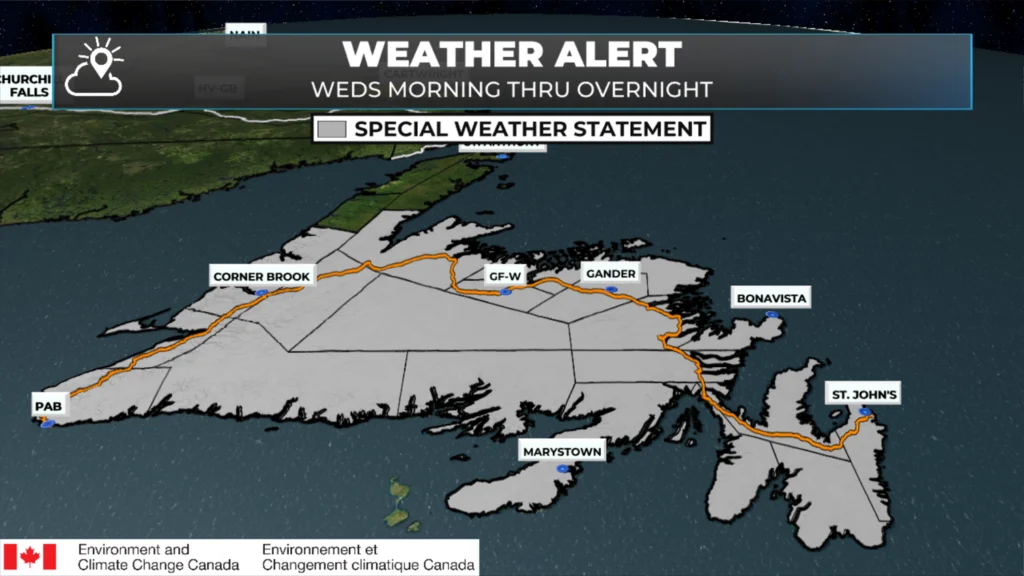
The areas in grey are the areas for which Environment Canada has issued a Special Weather Statement for Wednesday morning into the overnight.
Winter Storm Expected Wednesday Across Newfoundland
Environment and Climate Change Canada has issued a Special Weather Statement for most of Newfoundland as a significant winter storm is set to arrive on Wednesday. This will be a large, messy system capable of producing heavy snow, strong winds, pockets of heavy rain, and areas of reduced visibility.
Who’s Included?
St. John’s and vicinity
The Avalon Peninsula North
The Avalon Peninsula Southeast
The Avalon Peninsula Southwest
The Burin Peninsula
The Bonavista Peninsula
Clarenville and vicinity
Terra Nova
Bonavista North
Grander and vicinity
Bay of Expolits
Grand Falls-Windsor and vicinity
Buchans and the Interior
Deer Lake – Humber Valley
Corner Brook and vicinity
Bay St. George
Gros Morne
Channel-Por aux Basques and vicinity
Burgeo – Ramea
Connaigre
Timeline
Wednesday morning through overnight Wednesday night.
The storm will move in from southwest to northeast, spreading snow, wind, and for some areas—rain.
What to Expect
Snowfall
Widespread 15–30 cm for much of the Island.
Local pockets of 30–40 cm possible, though the exact location of the heaviest band remains uncertain.
Visibility will drop quickly at times under heavier bursts.
Wind
Gusts 80–100 km/h, especially along exposed and coastal areas.
Strong northeast to north winds will drive blowing snow—possibly widespread, but confidence on how extensive this becomes depends on temperatures hovering near the freezing mark.
Rain
Southeastern Newfoundland, including St. John’s and parts of the Avalon, may see a short period of snow before switching to significant rainfall (30–50 mm).
This could lead to minor localized flooding in low-lying or poor-drainage areas.
What Similar Storms Have Caused
Very poor driving conditions
Travel delays
Event cancellations and closures
Utility outages
Minor wind damage
Localized flooding in areas with poor drainage
Forecast Uncertainty
The biggest question mark right now is the rain-snow line and where the heaviest snow sets up. Small track shifts will make a big difference in what falls—and how much. Most of central, western, and northeastern Newfoundland appears likely to stay mainly snow, while the southeast sees more mixing and rain.
Winds are another factor to watch closely. They’ll be strong everywhere, but if temperatures remain just cold enough, blowing snow could become a major issue.
What’s Next
As newer data comes in, we’ll get a clearer idea of:
Where the heaviest snow will fall.
How much rain southeastern areas will see.
How widespread the blowing snow becomes.
I’ll have updated details and a more precise snowfall map as the storm gets closer.
Stay tuned.
Hoping wouldn’t see any amount til new year,oh well
Snow blower is tuned and ready.. love to see a white Christmas. Thanks meteorologist Eddie Sheerr for the update.. your doing a wonderful job sir.
Good morning and thank you Eddie for the update!
Thank you for the update…Be Prepared…Stay Safe!!
Thanks, Eddie.
Thank you Eddie! Your the best!
Hope you’re right and C.B.S. is mostly rain
Bring it on, thanks for the updates
Thanks for the update Eddy! Have a good day!
Thank you Eddy keep up the great work enjoy your day and to you and your family Merry Christmas and have a prosperous New Year -Cheers
Well this weather cancel crossings from nl,to north Sydney
Got my shovel, snowblower, snowsuit, umbrella, rain poncho, rubber boots and sunscreen all BBC ready to go!
Don’t see option to edit. Have no idea how “BBC” ended up in my comment. I certainly didn’t type it
Thanks Eddie!
You have Gander spelled incorrect in the “who’S included “ part. Thanks for the update I was waiting for as I plan to travel to St. John’s from Central on Friday . I hope it a good day or should I wait?
Thanks for the update Eddie. All I can say is YUK!! Have a great day
Thanks for the update Eddie
Thank you Sheerr Weather for keeping us informed of what to expect. I hope you had a great thanksgiving with your family in Florida!
Welcome back Eddie, guess we have to get snow sometime hopefully we won’t get much here in CBS
Not nice
Looks like I’m changing my travel plans for Tuesday and Wednesday.
Thank you for the information Eddie. I have family driving across the island on Thursday so I will be looking forward to updates as they become available
Thank you eddy. Planning to go to the city so I guess I will wait a couple of days.
Thank you Eddie for the detailed forecast!…Not much we can do about the in coming storm!..Just embrace it & wait for it to pass!
Happy Monday & have a great day!
Ty for the detailed forecast
Nice weather internet site! Much easier to read!
You’re very welcome, everyone! Thank you for visiting the website!
Love the service! Thanks Eddie! Hope all is well.
Wondering who thinks my husbands flight to BC back to work at 6am tomorrow morning is going to get canceled?