
Tuesday’s Forecast – Cold Night Ahead!
This forecast is sponsored by:

What began as a mild and drizzly morning in eastern Newfoundland has turned into anything but. The skies cleared nicely this afternoon, and temperatures dropped from a high of 6° or 7° this morning. It’s going to be a very cold night in the east, and across most of Newfoundland and Labrador, for two reasons: temperatures are already chilly, and the skies are clear across most of the province. That sets the stage for some areas to fall as low as -10° overnight, mainly in Labrador.
Tonight
Tonight is certainly going to be one of the coldest we’ve seen so far this fall across Newfoundland. Some parts of central Newfoundland fall well below freezing, potentially colder than -6° or -7°, while in the east, lows are closer to -2°.
It’s chilly in Labrador too, with temperatures dipping to -10° or close to it from the Churchill Valley back to Labrador City and Wabush.
Wednesday
We get a nice recovery on Wednesday, with sunshine much like today, but highs only between about 3° and 6° at the most in the afternoon. Enjoy the sun, because it may be hard to find for the rest of the week.
The exception to the sun is Labrador West, where an area of low pressure skirts to the west of Labrador. The clouds scoot in with it overnight, mostly over Quebec, and through the day Wednesday, some flurries, showers or even freezing drizzle work their way in, mainly well west of Lab City and Wabush. Some of that rain, and maybe a little light snow, may scrape southwestern Newfoundland Wednesday afternoon and Wednesday night.
Rain turns to snow in Labrador
On Thursday, another system takes shape to the west of Labrador over Quebec. It brings rain to Labrador first on Thursday, lingering in some areas into Friday. On Friday, it begins to interact with colder air, changing the rain over to snow, and the snow may linger into Saturday. If that’s the case, it may be significant.
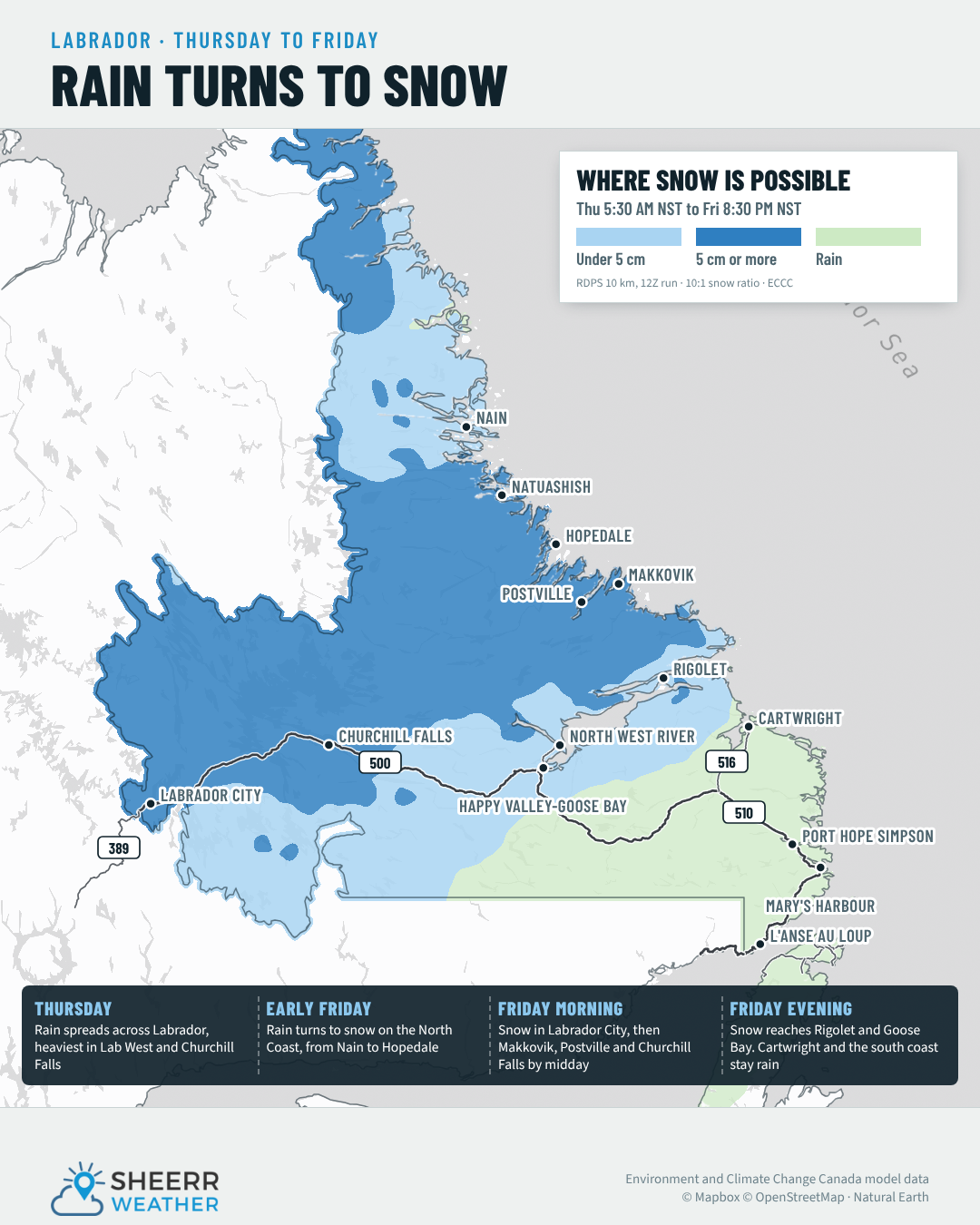
The map shows where the best chances are right now of seeing more than 5 cm of snow in Labrador. I know that’s not a super specific amount, but as we move through today and tomorrow, the snowfall forecast will get more specific. If the snow lingers into Saturday, some places will certainly see way more than 5 cm. Looking at the 7-day forecast for the Big Land, rain and snow move in on Thursday, continue into Friday, and potentially into Saturday in some areas, especially in the east and south. I’ll be watching it very closely.
Looking ahead
Across Newfoundland, the weather looks pretty quiet for the rest of the work week, with a chance of showers arriving in western areas later on Friday. Those may linger into Saturday and Sunday, and with that comes some warming as we head into a slightly warmer and slightly different weather pattern next week.
Have a great Tuesday evening! I’ll have my Morning Briefing for you bright and early tomorrow morning.
Don’t forget to…
📱 Get the Sheerr Weather App in the Apple App Store and Google Play Store for my latest updates.
📺 Tune into Sheerr Weather 24, my 24-hour weather channel on YouTube.
🗺️ Check out the Map Room to see all the latest weather observations for the Province.
🎥 Check out the Provincial Highway Cams to see 👀 what’s going on around our highways.
thanks Eddie