
Tuesday Morning’s Weather Briefing — November 3, 2026
Good Tuesday Morning!
- Rain showers are moving across the Avalon early this morning along a cold front, and they clear out by 7 or 8 AM.
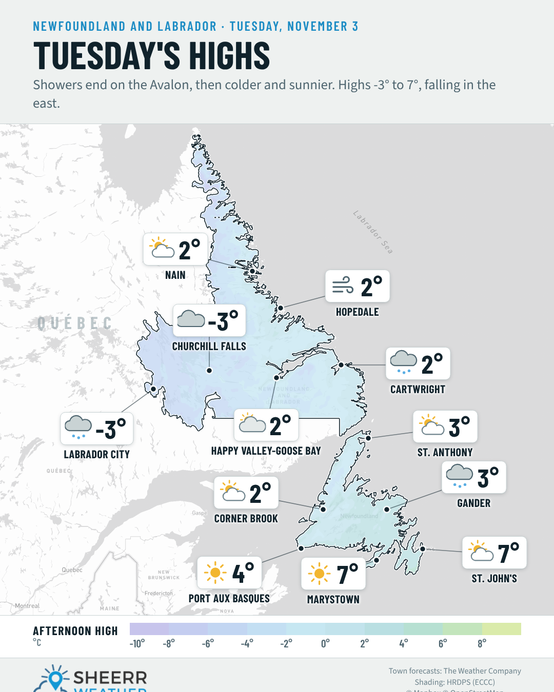
- Temperatures fall through the day in the east: from 7° or 8° this morning on the Avalon and Burin to 0° to 2° this afternoon, under sunny skies.
- A chilly but brighter day elsewhere on the Island, with highs of 2° to 5° and a few early flurries around Gander. Windy on the Bonavista Peninsula, with northwest winds 40 to 55 km/h.
- Labrador: a few flurries in Lab West and Cartwright this morning, highs of -3° to 2°, and windy on the coast, with gusts near 60 km/h in Cartwright.
- A cold night tonight, with lows of -6° to -1° on the Island and down to -10° in Churchill Falls.
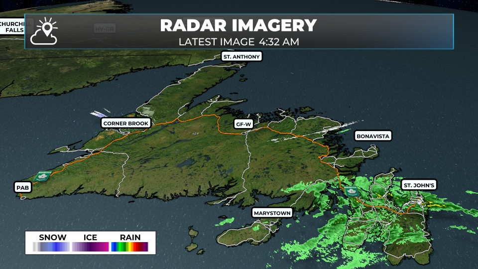
The cold front I talked about last night is moving through eastern Newfoundland right now. Radar at 4:32 AM shows rain showers across the Avalon, including the Metro, Conception Bay, Placentia Bay and the southern Avalon, with a few on the eastern side of the Burin Peninsula. There are also a few flurries showing up near Corner Brook and north of Grand Falls-Windsor, and Gander reported some light snow early this morning.
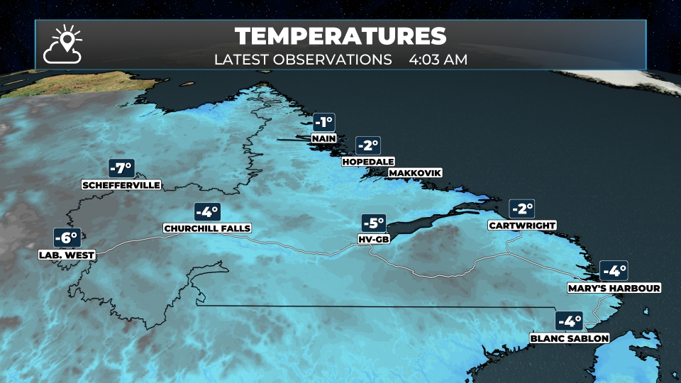
Temperatures are below freezing in much of central and western Newfoundland and across Labrador, from -3° in St. Anthony to -7° in Labrador City, while it’s still 6° to 7° on the Avalon ahead of the front.
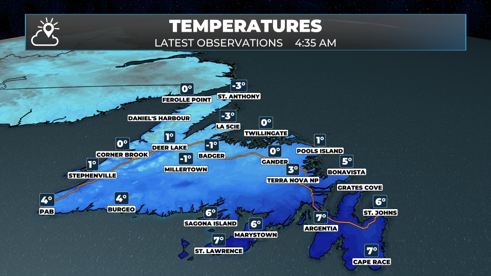
Once the front clears the Avalon this morning, the skies clear out and the colder air moves in. That means today’s highs on the Avalon and Burin Peninsulas happen this morning, with temperatures falling to 0° to 2° this afternoon, even with the sunshine. Elsewhere on the Island, highs only reach 2° to 5°.
This morning’s update is sponsored by CU Financial Management.
Visit cufm.ca to learn more, or drop by their new office at 39 Pippy Place in St. John’s!
Eastern Newfoundland / the Avalon: A few showers early on the Avalon, then sunny by the afternoon. A morning high of 8° in St. John’s, with temperatures falling to 0° to 2° this afternoon. Northwest winds 15 to 30 km/h. Clear to partly cloudy tonight, with lows of -2° to -1°. Partly cloudy around Clarenville, with a high near 4°. Windy on the Bonavista Peninsula, with a mix of sun and cloud, a high near 6° and northwest winds 40 to 55 km/h, easing after midnight. Lows of -4° to 1°.
Central: A few flurries or snow showers around Gander ending by noon, then partly cloudy, with highs of 3° to 4°. Northwest winds 25 to 40 km/h in Gander. Mostly clear tonight, with lows of -6° to -3°.
West Coast: A mix of sun and cloud, with clouds building around Corner Brook this afternoon. Highs of 2° to 3° and northwest winds 15 to 25 km/h. Lows of -2° to -1° tonight.
South Coast: Sunny, with highs near 5° around Burgeo and Harbour Breton, and a morning high of 7° in Marystown, falling to 0° to 2° this afternoon. Northwest winds 15 to 30 km/h. Clear tonight, with lows of -4° to -2°.
Southwest / Wreckhouse: Abundant sunshine, with a high near 4° and north-northwest winds 15 to 30 km/h. Clouding over late tonight, with a low near 0°.
GNP and the Straits: Windy, with a mix of sun and cloud, turning generally sunny in St. Anthony this afternoon. Highs of 2° to 4°, with northwest winds 25 to 40 km/h. Lows of -3° to 0° tonight.
Labrador / the Big Land: Scattered flurries this morning in Labrador City, with a high near -3° and west-northwest winds 15 to 25 km/h. Cloudy in Churchill Falls, with a high near -3°. A mix of sun and cloud in Happy Valley-Goose Bay, with a high near 2°. Windy in Cartwright, with a few flurries this morning, a high near 2° and west-northwest winds 30 to 50 km/h. Sun and cloud in Nain, with a high near 2°. Lows tonight of -10° to -5°.
Looking ahead: Wednesday brings a mix of sun and cloud, with highs of 3° to 6° on the Island and 1° to 5° in Labrador. A bit of rain or wet snow moves into Lab West Wednesday night, and a couple of hours of wet snow or rain is possible in southwestern Newfoundland. Otherwise, it’s a quiet week, with no major systems in sight.
📱 Get the Sheerr Weather App in the Apple App Store and Google Play Store.
📍 Want more detail for where you live? Check out our new Regional Forecast pages for current conditions, local alerts, highway cams and the forecast for your area: Avalon · Eastern · Burin Peninsula · South Coast · West Coast · Long Range Mountains · Central · GNP & the Straits · Labrador West · Central Labrador · Labrador North Coast · Labrador South Coast
🗺️ Check out the Map Room to see all the latest weather observations for the Province.
🎥 Check out the Provincial Highway Cams to see 👀 what’s going on around our highways.
Thanks Eddie for the weather update.