
Rain, Wind and Snow Into Sunday
This forecast is sponsored by:

Our latest weather maker is moving through this Saturday morning, and it’s a far-reaching system. There’s rain across Newfoundland and it’s breezy, while Labrador is seeing rain and snow, with the snow reaching as far back as Lab West. The highway camera in Wabush along Route 500 is looking very wintry this morning, and so is Cache River, although I’d say it’s pretty there, too. Goose Bay has a little bit of snow, but the roads appear to be just wet for the time being.
Today brings more wind to the Island and more snow to Labrador before it all winds down by tomorrow morning. There’s also a little bit of snow in the forecast for parts of Newfoundland later tonight and tomorrow.
New: wind warning for the Avalon Peninsula
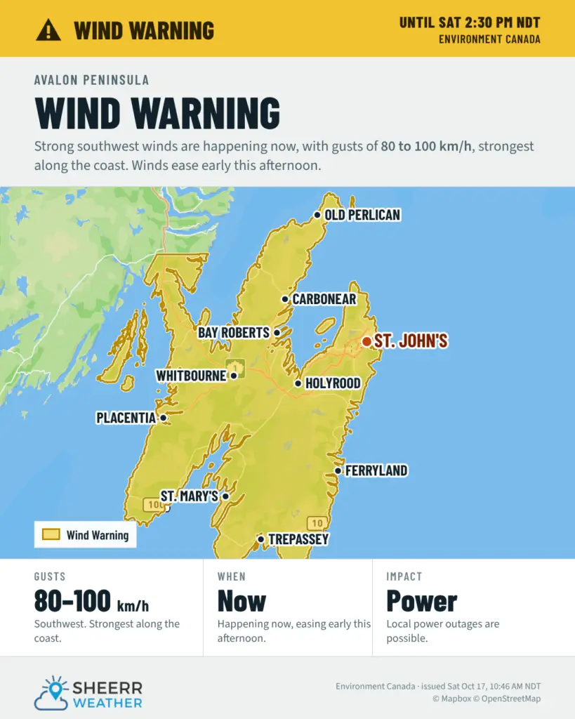
Environment Canada has just issued a wind warning for the Avalon Peninsula, including St. John’s and vicinity, Avalon Peninsula North, Avalon Peninsula Southeast and Avalon Peninsula Southwest. Strong winds are occurring over some areas, with maximum wind gusts of southwesterly 80 to 100 km/h, ending early this afternoon. The strongest winds are likely to occur along the coast.
Local utility outages are possible, so secure loose objects.
Wind warning for northern and northeastern Newfoundland: this afternoon and early this evening
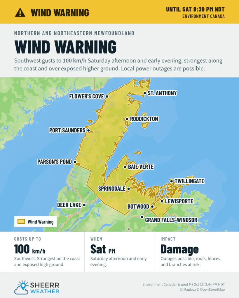
A large part of central, northern and northwestern Newfoundland will see high winds between later this morning and this evening. Environment Canada has a wind warning in effect for:
- Bay of Exploits
- Green Bay – White Bay
- Northern Peninsula East
- Parson’s Pond – Hawke’s Bay
- Port Saunders and the Straits
Damaging winds are expected, with maximum wind gusts of southwesterly 100 km/h this afternoon and early this evening. The strongest winds are likely along the coast or over exposed higher elevations. Local utility outages are possible, so secure any loose objects.
The winds pick up from the south and southwest through the afternoon, especially around 2 or 3 o’clock, when it looks like St. Anthony peaks at about 100 km/h. After that, the winds slack off quite sharply. It’s still on the breezy side tomorrow morning, but nowhere near as windy as it will be for the rest of today.
Mild on the Island, near freezing in Labrador
It’ll be quite mild across much of Newfoundland today in the southerly flow ahead of the low. Labrador is cooler on the north side of the system, with temperatures near freezing in areas of rain and snow.
As the low moves off to the northeast, snow continues across much of Labrador into the early afternoon. By this evening, showers return to the Avalon Peninsula as the cold front moves through, and another round of rain works its way across the Burin, Avalon and Bonavista peninsulas overnight. If you have plans this evening, it’s not a bad idea to have a rain jacket handy, although the bulk of that rain looks like it stays offshore, at least as it looks this morning.
How much rain and snow?
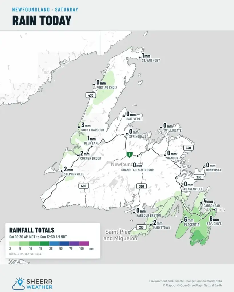
Rain: Another 5 to 20 mm or so is possible between now and Sunday over parts of southern and southeastern Newfoundland, with lesser amounts to the west and northwest, where most of the rain is now done.
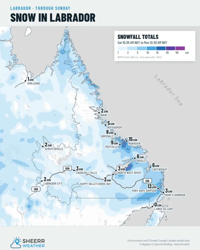
Snow in Labrador: The most significant snow is in southeastern Labrador today. If you’re travelling the Trans-Labrador Highway between the Port Hope Simpson area and up toward Cartwright, there could be a short swath of 10 to 20 cm, with much less to the south and north of there. In some areas, it’s already underway. Environment Canada’s special weather statement continues for Eagle River, Cartwright to Black Tickle, Norman Bay to Lodge Bay, and Red Bay to L’Anse-au-Clair, with 5 to 10 cm of wet, heavy snow possible inland and over higher terrain today, and roads that could become slippery and difficult to navigate.
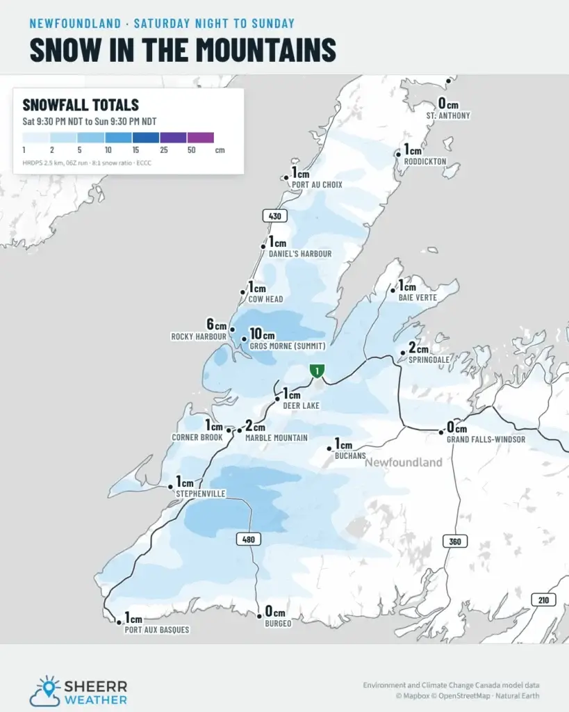
Snow in western Newfoundland: The higher terrain of western Newfoundland could see some snow between later tonight and about midday tomorrow, as another piece of energy rotates through. Up in Gros Morne, 15 to 20 cm is possible at the summits, with lesser amounts lower down. The higher terrain around Corner Brook, in places like Massey Drive, could pick up a couple of centimetres late tonight and during the day tomorrow.
The week ahead
The weather improves for most of us on Sunday, although it’ll be on the cool side, and the next few days look fairly calm across most of Newfoundland. In Labrador, the weather gets nicer over the next couple of days once we get through today. It won’t be super warm or super cold, but overnight lows will be cold, and the next chance of rain or snow looks to be in Lab West, potentially on Thursday.
Have a great Saturday, follow along for updates, and I’ll see you tomorrow!
Don’t forget to…
📱 Get the Sheerr Weather App in the Apple App Store and Google Play Store.
🗺️ Check out the Map Room to see all the latest weather observations for the Province.
🎥 Check out the Provincial Highway Cams to see 👀 what’s going on around our highways.