
Rain and Snow Remain in the Forecast as the Weekend Nears
This evening’s forecast is sponsored by CU Financial Management
Expert financial advice across Newfoundland and Labrador, with an expanded office now open at 39 Pippy Place in St. John’s. Visit cufm.ca to learn more!
As our latest area of low pressure begins to loosen its grip on Newfoundland and Labrador, another one is taking shape to our southwest, and it will bring another round of rain and snow to the province beginning Friday afternoon.
Tonight: quiet, with a few icy patches
Across Newfoundland, the weather is pretty quiet tonight, with lows near 0°. There could be a few icy patches tomorrow morning as you head out the door, so keep that in mind. In Labrador, a little light snow and rain persists, but most of it will be over fairly remote areas and along the coast, and the coast will see mainly rain.
Friday: dry start, wet finish
On the Island, we start dry tomorrow, with highs of 3° to 6° in the afternoon. You might look out the window at that first bit of daylight and think I’m wrong again, that it’s just too nice for anything to happen today. I’d say hurry up and wait, because once we get past midday, the next round of precipitation moves in, and by 5 or 6 PM it’s back in the picture. For the south coast, the Avalon and the northeast coast, it’s rain.
By tomorrow evening and tomorrow night, areas around Corner Brook, the Northern Peninsula and some of the higher terrain of central Newfoundland will see some snow. I don’t want to call it significant, but it could be 5 to 10 cm or more, especially over higher terrain, on top of what’s fallen over the last couple of days. The snow shifts into southeastern Labrador by midday Saturday and continues on the Northern Peninsula through midday Saturday, before winding down on the Island by Saturday evening.
In Labrador tomorrow, the coast sees rain, but just inland there could be wet snow, and it could be heavy in spots. Farther west, it’s not looking overly busy, but enjoy the break, because it won’t last long.
How much snow?
From midday tomorrow through Saturday evening, no snow is expected in the eastern half of Newfoundland, with just a trace for Grand Falls-Windsor and Gander as of now. Around Corner Brook, Pasadena and Deer Lake, a couple of centimetres, mainly on grassy surfaces, is possible tomorrow afternoon, evening and night. The snow could be more significant on the Northern Peninsula, where areas like Roddickton could pick up more than 10 cm if that band of snow comes to fruition on Saturday. St. Anthony is straddling the line between 5 to 10 cm and 10 to 20 cm. In southeastern Labrador, north of Red Bay and south of Mary’s Harbour, 10 to 20 cm is possible in the same time frame.
Heavy rain for the Labrador coast
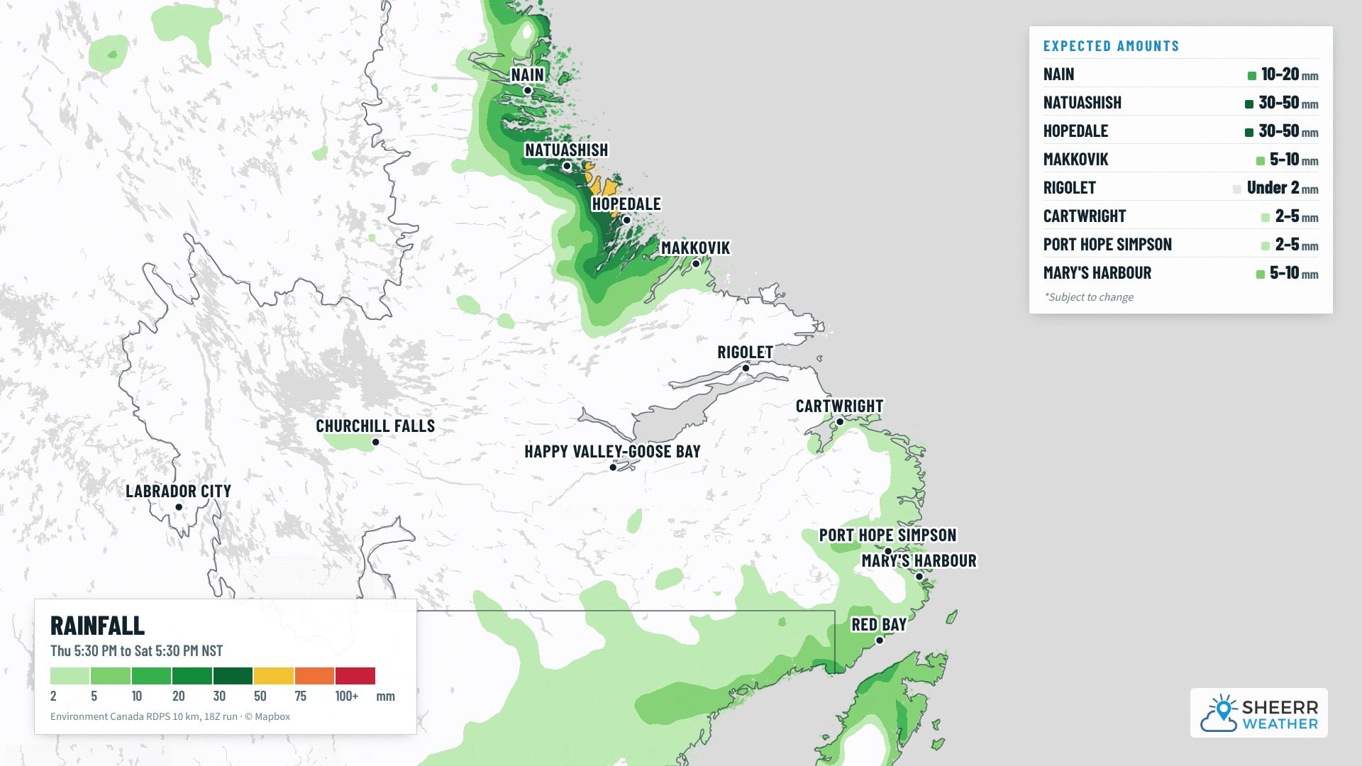
Parts of coastal Labrador may see rain and snow persist well through Saturday and possibly into Sunday, and it could be significant amounts of both, especially over higher terrain, as this is another slow-moving system. Along part of the north coast, not much snow shows up on the snowfall map, but that’s not because nothing will fall: most of it will likely be rain, potentially 30 to 50 mm between now and later Saturday, heaviest around Hopedale and Natuashish. I wouldn’t be surprised to see a special weather statement for heavy rainfall from Environment and Climate Change Canada. Just inland, it’s a different story: the remote areas of northern Labrador, inland and over higher terrain, could really pile up the snow over the next couple of days.
The week ahead
For Newfoundland, temperatures stay on the cool side, about where they should be for the time of year, but the weather gets nicer once we get past Saturday or Sunday, and that trend generally continues into next week.
In Labrador, there’s snow in the south into Saturday, and the same for parts of the north coast, although it could be mixed with rain there, as temperatures will be very borderline. The same goes for the south coast, where areas right along the water could see a rain and wet snow mix. In Lab West and the Goose Bay area, it’s more likely flurries over the next few days, with a bit of a warming trend looking ahead to next week. We’ll see how long that lasts.
It’s been a long week, folks! Have a very good Thursday evening, and I’ll have my next forecast update for you bright and early tomorrow morning.
Don’t forget to…
📱 Get the Sheerr Weather App in the Apple App Store and Google Play Store for my latest updates.
📺 Tune into Sheerr Weather 24, my 24-hour weather channel on YouTube.
🗺️ Check out the Map Room to see all the latest weather observations for the Province.
🎥 Check out the Provincial Highway Cams to see 👀 what’s going on around our highways.