
Another System Arrives For Mid/Late Week
This evening’s forecast is sponsored by CU Financial Management
Expert financial advice across Newfoundland and Labrador, with an expanded office now open in St. John’s. Visit cufm.ca to learn more!
For most of Newfoundland, it turned into a decent afternoon after this morning’s rain, which was rather unpleasant in the east, if I may say so myself. Temperatures on the Island reached 8° to 11° heading into the 4 o’clock hour, so it felt more like an early fall afternoon.
Labrador is a different story. There’s plenty of cloud over the Big Land, and under it some rain and some snow. It was 0° in Wabush and 1° in Churchill Falls this afternoon, and the Wabush camera showed freshly fallen snow beside the road. There was also some snow on the ground in Goose Bay earlier today. It has since melted, but that might not be the case for long.
Light snow in western Labrador tonight
An area of low pressure has been spinning toward Labrador through much of today, and it works into the Big Land overnight. That keeps a little bit of snow going at times from the Churchill Valley back to Labrador City and Wabush, and into extreme eastern Quebec. There will also be a few rain showers in eastern Labrador tonight in the onshore southerly flow.
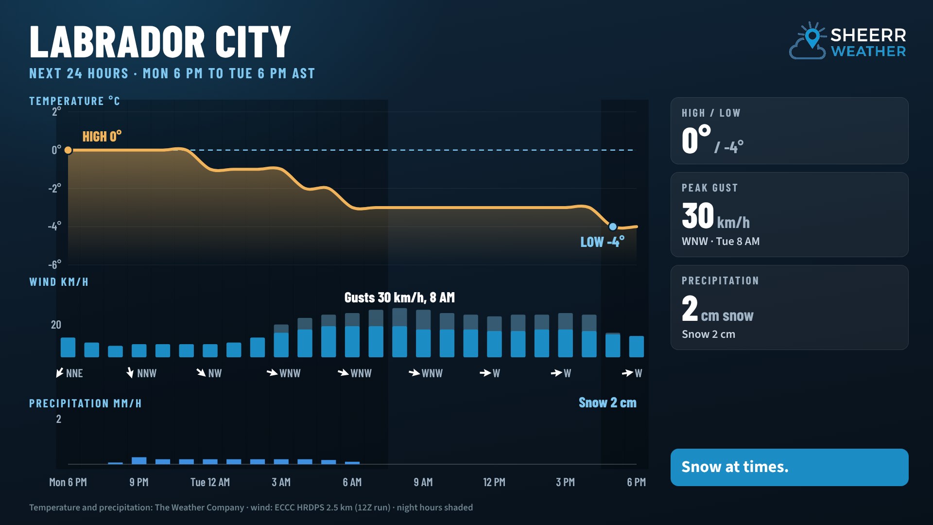
Not a lot of new snow, though. In Labrador City, light snow falls mainly between about 9 PM and 6 AM, for about 2 cm, with winds gusting to 30 km/h. Temperatures hold near 0° through much of the night, then fall to about -4° later in the day Tuesday as colder air moves in. That colder air sets the stage for a busy middle part of the week.
Across the rest of the province tonight, lows dip into the single digits on the Island, and between 2° and -4° in Labrador, with a little light snow lingering.
Tuesday: a narrow band of heavier rain
Tomorrow, tonight’s low scoots off to the north. But notice the rain redeveloping from just west of the Connaigre Peninsula, almost paralleling the Bay d’Espoir Highway, to just west of Grand Falls-Windsor and the Badger area by midday. Most of it stays west of the Avalon and southwest of the Bonavista Peninsula. It’s a narrow band of relatively heavy rain, and it’s the harbinger of things to come.
Western Newfoundland is mostly dry tomorrow, and so is the Avalon, though some fog is possible here and there. In Labrador, it won’t be quite as cool as today, with highs near 6° in the east and southeast.
Mid to late week: low pressure and colder air
That rain is in response to an area of low pressure moving in, and that low plays a bigger role in our weather from later Tuesday, Tuesday night and Wednesday, possibly into Thursday. It slowly passes eastern Newfoundland on Wednesday, then moves toward Labrador on Thursday. At the same time, colder air begins to move in from the north and west, and I think you know where I’m going with this: there’s potential for snow over parts of Newfoundland beginning Wednesday afternoon. The question is where.
By 6 AM Wednesday, rain covers a large part of Newfoundland. As the low backs toward the northwest and pulls in the cold air, snow first shows up northwest of Deer Lake, on the eastern side of the Long Range Mountains and the western side of the Green Bay–White Bay area.
Through Wednesday afternoon, a little more snow shows up across parts of interior and western Newfoundland. Temperatures will be borderline, so lower elevations likely see rain, while higher terrain likely turns to snow by Wednesday evening in parts of central and western Newfoundland.
The snow also gets going in Labrador Wednesday evening, especially away from the southeast coast, from Postville and Makkovik down toward Goose Bay, and it may continue into early Thursday morning. Then the snow pushes back west. It looks like it changes to rain in the Goose Bay area and along the coast, but Churchill Falls, Labrador City and Wabush go right back into snow Thursday morning, continuing into later Thursday before winding down. Parts of western Newfoundland are still seeing snow Thursday morning as well.
So how much snow?
In situations like this, it’s a difficult forecast. You might see a person or a single computer model run laying down a whole lot of snow across Newfoundland. Right now, I don’t see that as a likely possibility. I do see some snow, so the better question is: what are the chances?
This map shows the chances of seeing 10 cm of snow or more across Newfoundland from Wednesday into Thursday, based on Environment Canada’s ensemble guidance.
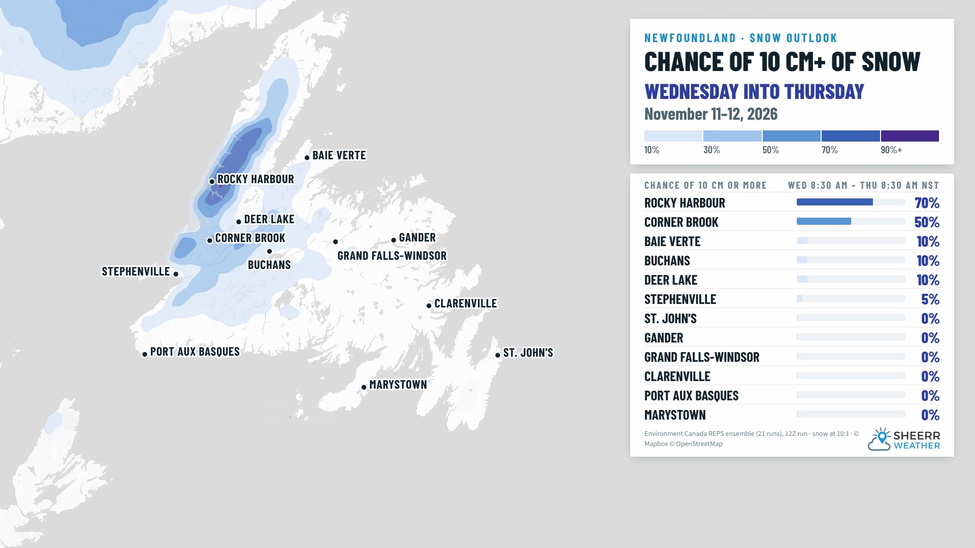
Rocky Harbour has a 70% chance of seeing that much snow, and Corner Brook is about a 50-50 shot right now. Away from those two areas and the Long Range Mountains, the chances of 10 cm are very slim: St. John’s 0%, Stephenville 5%, Buchans 10% and Gander 0%. That doesn’t mean it won’t change, but this is how it looks right now.
When you look at a weather map, it’s important to understand the context. That’s where meteorology really helps, especially in these shoulder seasons. I’ll keep an eye on it.
Labrador: a different story
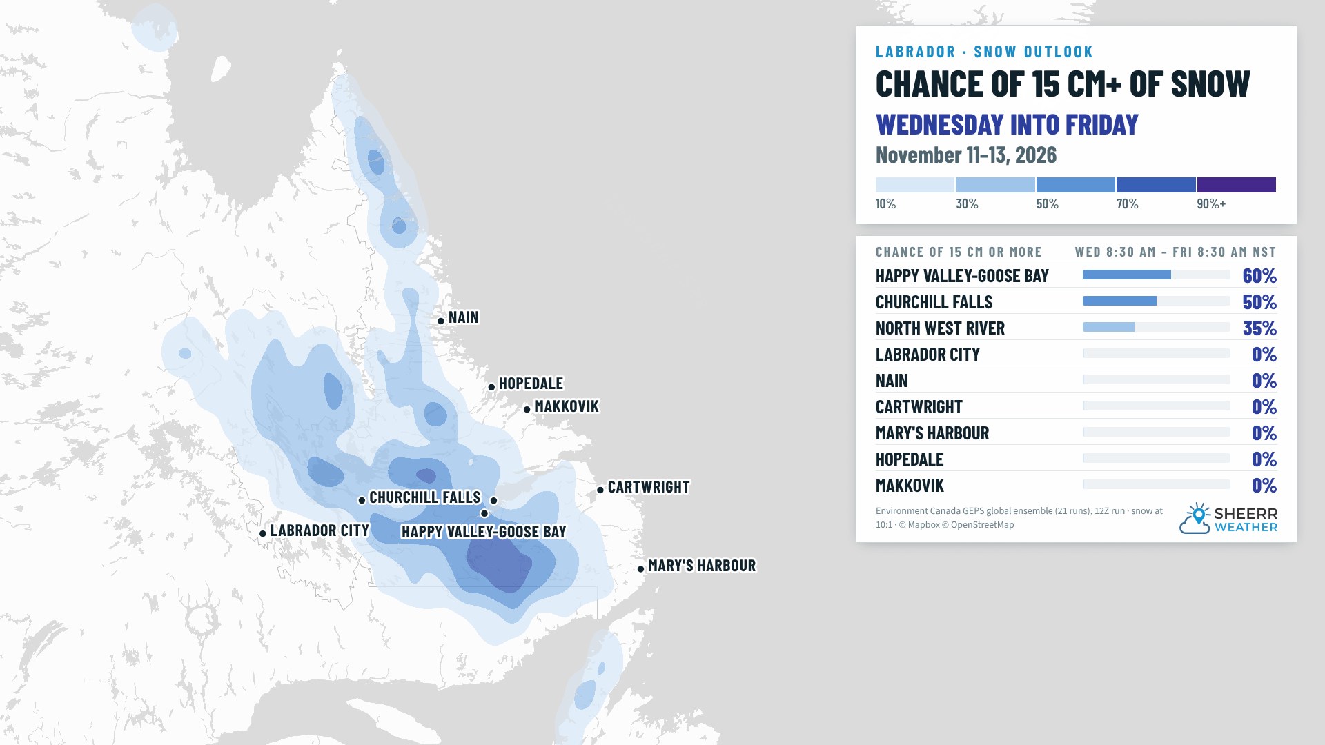
In Labrador, Happy Valley-Goose Bay has a 60% chance of seeing more than 15 cm of snow from Wednesday into early Friday. Churchill Falls is a 50-50 shot, North West River is at 35%, and Labrador City is at 0%. The snow in Labrador City doesn’t start until later in the day Thursday, though, so if this map went out to Saturday, that number would change a bit.
Right now, significant snow is very possible in Labrador late in the week, and parts of western Newfoundland could potentially get a special weather statement from Environment and Climate Change Canada. I’ll be watching that closely too.
The week ahead
In Labrador, temperatures in the south and the north stay above freezing through Friday. In the west, snow on Thursday lingers into Friday and winds down later Friday. In the Goose Bay area, snow arrives Wednesday and will likely pile up before changing to rain on Thursday, lingering into Friday. Saturday and Sunday look cold.
Across Newfoundland, parts of central and western Newfoundland may see rain mixing with or changing to snow later Wednesday into Thursday, mainly inland and over higher terrain. On the West Coast, the high on Thursday is around 3° for now, and a little cooler if the snow moves in. Once you go up in elevation into the Long Range Mountains, it’s certainly going to snow, at least that’s how it looks from my chair right now.
Have a very good Monday evening! I’ll see you bright and early tomorrow morning.
Don’t forget to…
📱 Get the Sheerr Weather App in the Apple App Store and Google Play Store for my latest updates.
📺 Tune into Sheerr Weather 24, my 24-hour weather channel on YouTube.
🗺️ Check out the Map Room to see all the latest weather observations for the Province.
🎥 Check out the Provincial Highway Cams to see 👀 what’s going on around our highways.