
Next Low Brings Rain, Wind And Possibly Wet Snow Late Week
This forecast is sponsored by:

Wednesday began with a bit of cloud across parts of Newfoundland, but skies have turned progressively clearer as the afternoon has gone on. In Labrador, we’re seeing some cloud in the north, and that’s going to play a bigger role in the forecast later tomorrow and especially Friday. Those flurries and showers are on the leading edge of some colder air, which will interact with an area of low pressure currently spinning east of New Jersey. Together, they’ll bring rain, wind and possibly wet snow to parts of Newfoundland, beginning late tomorrow and lasting into early Saturday. It’s going to be a slow mover and a long-duration event.
Tonight and Thursday
Tonight in Labrador, we’ll see some rain showers and a little bit of snow, especially around Lab City and Churchill Falls. On the Island, it’s clear and cool, with lows near or a little above the freezing mark for most areas, although some spots will dip a little below.
Tomorrow, there are a few flurries or showers in Labrador, with highs of 2 to 7, and as warm as 9 in places like Mary’s Harbour. Across Newfoundland, most of us stay dry. The exception is the Burin and Avalon peninsulas, where rain arrives during the second half of the day and into tomorrow evening.
A slow-moving low for Friday
The low east of New Jersey moves slowly northeast, bringing rain to parts of coastal Nova Scotia by tomorrow morning while staying well south of Newfoundland. By tomorrow evening, rain spreads onto the Burin and Avalon peninsulas. As the low continues north, it will interact with a cold front coming out of Labrador and some energy swinging off the continent. That will cause the low to slow down and intensify south of Newfoundland tomorrow night and Friday, and its forward progress will slow down drastically.
By 6 AM Friday, rain is falling across much of southeastern Newfoundland and along the south coast, but the winds are screaming out of the north. Those northerlies will bring in air cold enough to support snow very close to the ground. Whether it makes it all the way to the ground, I’m not sold on just yet, because it is only October. But I do think there’s a chance this produces snow over the higher elevations later in the day Friday.
By midday Friday, the computer guidance is showing snow from Connaigre down through Saint-Pierre and the Burin Peninsula. My question is whether that’s snow or rain, since it’s snow almost to ground level before it changes to rain. Often in situations like this, I think it’s going to be too warm for snow, and it’s not. So I do think some areas of southern and central Newfoundland could see some snow Friday afternoon. Whether that makes it onto the Avalon Friday night, I’m not sure. It will ultimately depend on the low’s forward progress. The GRAF model isn’t overly bullish on bringing it much farther north, but even so, we’re still looking at the potential for significant rainfall, a little bit of snow and some very gusty winds around the system.
How much rain and snow?
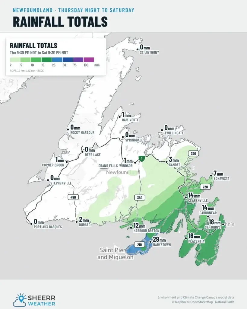
As it stands right now, the Burin Peninsula is likely to see the most rain, with 25 to 50 mm. Across the Avalon Peninsula and northeastern Newfoundland, out toward Clarenville and the Bonavista Peninsula, amounts look to be around 7 to 14 mm, with lesser amounts to the north and west.
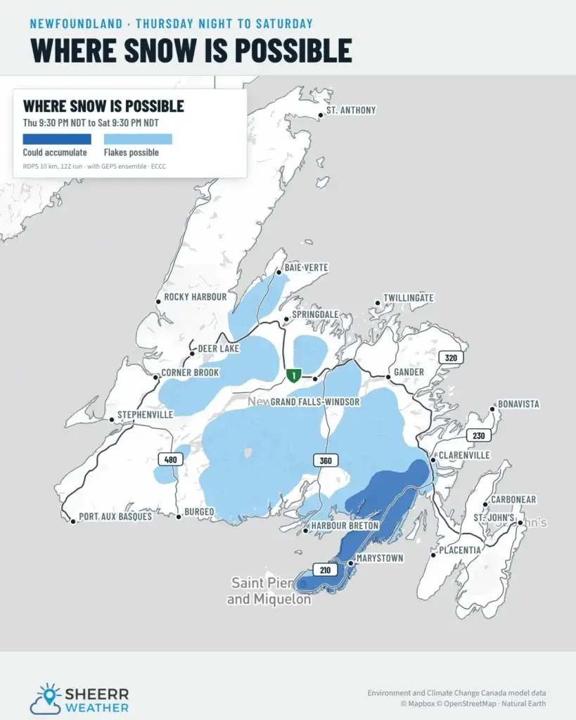
As for snow, it could accumulate on the Burin Peninsula and maybe the north side of Fortune Bay, and flakes are possible through much of the interior of southern and central Newfoundland during the day Friday and maybe into early Saturday morning. Places right along the coast, like Marystown, St. Lawrence, Grand Bank and Lawn, will likely see rain. But on the Burin Peninsula Highway, especially once you get south of Swift Current, it could very well be snow Friday afternoon, so watch that closely if you’re travelling.
My confidence in this forecast isn’t super high right now, because the placement of the low will be crucial in whether we see snow or it stays to the south, and in how much rain we get. I’ll work that out and have an update for you tomorrow as this thing rolls in.
Wind Friday
The wind won’t be too impressive to start Friday, but it picks up as the day goes on. By Friday evening, gusts of 70 to 80 or even 90 km/h are possible for the Burin and Avalon peninsulas and the northeast coast. This may require a wind warning or a special weather statement from Environment Canada, so keep an eye out for those. The winds calm down once we get through Friday night, setting the stage for a less breezy but potentially drizzly Saturday over parts of eastern and northeastern Newfoundland.
The week ahead
In the 7-day forecast, drizzle lingers into Saturday on the Avalon, with a high of only 6, and it will be breezy. The ECT50 takes place on Saturday, and if it’s rainy, cold and drizzly, it won’t be the best experience for the runners, who are obviously very tough individuals. Tackling a 50 km race on the East Coast Trail on a lovely day would be hard enough, let alone a cold, windy, drizzly one. If I were wearing a hat, I’d take it off to you, and I’ll have a forecast for the ECT50 posted for you, probably tomorrow. Once we’re through Friday and Saturday, the weather looks pretty decent the rest of the way.
In Labrador, it’s mostly sunshine, with maybe a little rain and snow on Sunday. It’s pretty unimpactful weather, but when the weather is impactful in Labrador, I’ll certainly harp on it, just like I do anywhere else.
Have a great evening, folks, and I’ll see you bright and early tomorrow morning!
Don’t forget to…
📱 Get the Sheerr Weather App in the Apple App Store and Google Play Store for my latest updates.
📺 Tune into Sheerr Weather 24, my 24-hour weather channel on YouTube.
🗺️ Check out the Map Room to see all the latest weather observations for the Province.
🎥 Check out the Provincial Highway Cams to see 👀 what’s going on around our highways.