
UPDATED | Environment Canada issues Winter Storm Watch, Special Weather Statement and Coastal Flood Statements for Monday into Tuesday
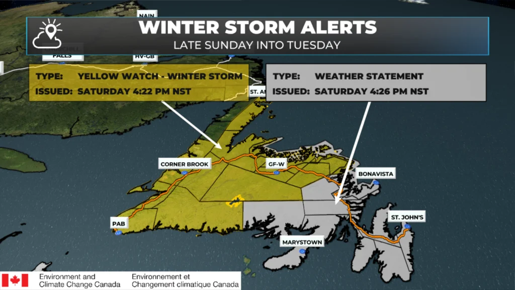
A potent winter storm has sights set on Newfoundland for the Sunday night through early Tuesday time frame. This system is promising to bring heavy snowfall, high winds, and rain to the Island in that time frame. Ahead of this system’s arrival, the Environment and Climate Change Canada Weather Office in Gander has issued a Winter Storm Watch for much of northeastern, central, and western Newfoundland and a Coastal Flood Statement for the north-facing shores from Green Bay – White Bay to Bonavista Bay.
Remember that the lack of an alert for YOUR area doesn’t mean there will not be impactful weather. It simply means the weather isn’t meeting the criteria to trigger a warning at this time. Outside this alert area, including on the Avalon, there will be snow, wind, and rain associated with this system. The snow may be significant in some areas. Winds will also be high on the Avalon Peninsula Monday night, and there is a good chance of new or expanded warnings before this system’s arrival.
Winter Storm Watch — Northeast, Central and Western Newfoundland
A Winter Storm Watch has been issued by Environment and Climate Change Canada for the following areas from Sunday night through Tuesday morning:
Corner Brook and vicinity
Deer Lake – Humber Valley
Gros Morne
Buchans and the interior
Grand Falls-Windsor and vicinity
Bay of Exploits
Bonavista North
Gander and vicinity
Green Bay – White Bay
Northern Peninsula East
Impact Level: Moderate
Forecast Confidence: High
Timing
Overnight Sunday night through Tuesday morning
Areas Affected
Northeastern Newfoundland
Central Newfoundland
Parts of western Newfoundland
Northern Peninsula East
Snowfall
Potential snowfall: 20 to 40 cm
Higher amounts are possible
Wind
Northeastern Newfoundland and the Great Northern Peninsula:
Easterly wind gusts up to 80 km/h, shifting to northwesterly 90 to 120 km/h
Western Newfoundland:
Northeasterly wind gusts up to 60 km/h, shifting to northwesterly 60 to 80 km/h
Potential Impacts
Similar storms in the past have resulted in:
School closures and cancellations of community activities
Disruptions to public services
Delays or cancellations of ferry services
Additional Information
The combination of snow and strong winds is likely to result in near blizzard-like conditions with poor visibility. There remains uncertainty regarding where the heaviest snowfall will occur; however, the potential exists for significant accumulations in some locations.
Roads and walkways may be difficult to navigate, and visibility may be suddenly reduced to near zero at times.
Residents are advised to consider rescheduling travel and outdoor activities.
About a Winter Storm Watch
Winter Storm Watches are issued when hazardous winter weather conditions are possible.
Winter Storm Watch – Southwestern Newfoundland
A Winter Storm Watch has been issued by Environment and Climate Change Canada for the following areas from Sunday night through Tuesday morning:
Burgeo – Ramea
Channel–Port aux Basques and vicinity
Bay St. George
Impact Level: Moderate
Forecast Confidence: High
Timing
Overnight Sunday through Tuesday morning
Areas Affected
Southwestern Newfoundland
Snowfall
Potential snowfall: 15 to 25 cm
Higher amounts possible inland and over higher terrain
Wind
Northeasterly wind gusts up to 60 km/h, shifting to northwesterly 80 to 100 km/h
Potential Impacts
Similar storms in the past have resulted in:
School closures and cancellations of community activities
Disruptions to public services
Delays or cancellations of ferry services
Additional Information
An approaching weather system is expected to bring adverse winter weather to the region. The combination of snow and strong winds may result in blizzard-like conditions with poor visibility, particularly inland and over higher terrain. While there remains uncertainty regarding total snowfall amounts, the potential exists for significant accumulations in some areas.
Roads and walkways may be difficult to navigate, and visibility may be suddenly reduced to near zero at times. Residents are advised to consider rescheduling travel and outdoor activities.
About a Winter Storm Watch
Winter Storm Watches are issued when hazardous winter weather conditions are possible.
Special Weather Statement – Eastern Newfoundland
A Special Weather Statement has been issued by Environment and Climate Change Canada for the following areas from Sunday night through Tuesday morning:
Avalon Peninsula North
Avalon Peninsula Southeast
St. John’s and vicinity
Avalon Peninsula Southwest
Burin Peninsula
Connaigre
Bonavista Peninsula
Clarenville and vicinity
Terra Nova
Timing
Overnight Sunday through Tuesday morning
Areas Affected
Eastern Newfoundland
Precipitation
Snow is expected to begin Sunday night
Precipitation is forecast to change over to rain
Ice pellets and freezing rain are possible during the transition
Rain is expected to change back briefly to snow Monday evening
Snowfall and rainfall accumulations are not expected to be significant.
Wind
Easterly wind gusts of 60 to 80 km/h, shifting to northwesterly 100 to 130 km/h
Strongest gusts expected along the coast
Potential Impacts
Strong winds combined with fresh falling snow may lead to reduced visibility in blowing snow, particularly Monday night
Localized travel difficulties are possible during periods of poor visibility
Additional Information
Following the initial snowfall Sunday night, a complex precipitation sequence is expected, including a transition to rain with the possibility of ice pellets or freezing rain. Very strong northwesterly winds are forecast to develop Monday evening as precipitation briefly changes back to snow.
While overall snowfall and rainfall amounts are expected to remain limited, wind-driven blowing snow may significantly reduce visibility in some areas.
About a Special Weather Statement
Special Weather Statements are issued to alert the public to potentially hazardous weather conditions that do not currently meet warning criteria but may still cause impacts.
COASTAL FLOOD STATEMENT
A Coastal Flood Statement has been issued by Environment and Climate Change Canada from late Monday evening through Tuesday morning for the following coastline areas:
Green Bay
Bay of Exploits
Gander Bay to Lumsden
Northern and western shorelines of Bonavista Bay
Southern shoreline of Bonavista Bay
Significant storm surge and wave activity are possible for the northeast coast of Newfoundland from Green Bay to Bonavista Bay.
Timing
Late Monday evening until Tuesday morning
Most significant effects near high tide
High tide: 4:00 A.M. to 6:00 A.M. Tuesday morning
Waves
Maximum wave heights: 7 to 9 metres, breaking upon approach to shore
Additional Information
Coastal waters can significantly exceed the highest astronomical tide when storm surge combines with strong wave action near high tide. A combination of surge and wave action could cause localized flood damage along parts of the coast.
There will be more updates on the incoming weather later today and tomorrow, and of course, through the storm Monday and Tuesday. Please download my app if you haven’t already. Also, follow me on my social networks for more frequent updates!