
Avalon Peninsula Under Winter Storm Warning from tonight into Monday
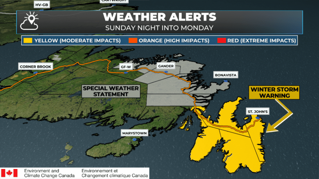
Weather alerts from ECCC NL as of 8:35 AM NST (Jan 4, 2026).
A fast-moving winter storm will bring snow and wind to the Avalon Peninsula and some adjacent areas of eastern Newfoundland beginning tonight and continuing into Monday morning.
The Environment and Climate Change Canada Weather Office in Gander has issued a Yellow Level Winter Storm Warning for the following areas:
The Avalon Peninsula North
The Avalon Peninsula Southeast
The Avalon Peninsula Southwest
St. John’s and vicinity
Total snowfall of 15 to 30 cm is expected, with locally higher (or lower) amounts possible. Wind speeds will gust from the north as high as 70 km/h from near midnight tonight through about midday Monday. The highest snowfall totals are expected over the eastern side of the Avalon Peninsula (think southern shore to Torbay/Flatrock/Pouch Cove)
Snowfall rates will be approximately 2 to 4 cm per hour, with locally higher rates possible within heavier snowfall bands. Strong winds will accompany the snow throughout the event and will result in areas of blowing snow.
Winter Storm Warnings are issued when multiple types of severe weather, such as snow, freezing rain, wind, and rain, are expected.
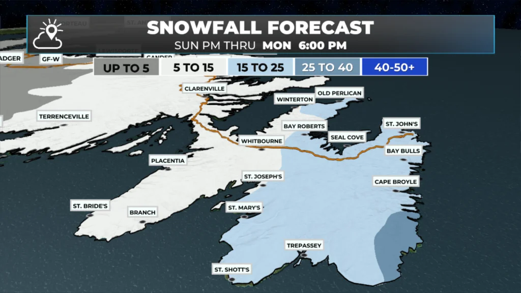
Tap to enlarge — Expected snowfall from tonight into monday evening (Jan 4 – 5, 2026).
A Special Weather Statement is in effect from overnight tonight until Monday afternoon for the following areas due to the threat of accumulating snow from Sunday night until Monday afternoon:
Clarenville and vicinity
Bonavista Peninsula
Terra Nova
Gander and vicinity
Bonavista North
Bay of Exploits
The area of low pressure passing east of the Avalon Peninsula will bring accumulating snow and blowing snow, reducing visibility, to parts of central, eastern, and northeastern Newfoundland from overnight into Monday afternoon.
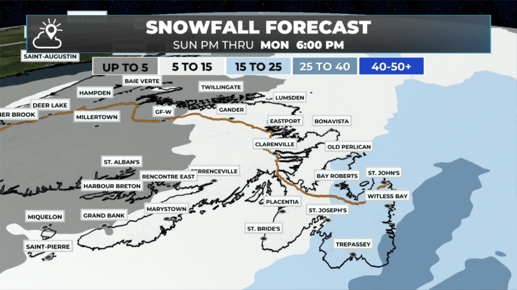
Tap to enlarge — Expected snowfall from tonight into monday evening (Jan 4 – 5, 2026).
Expected Snowfall By Location (As of Sunday Morning and Subject to Change)
15–25 cm (light blue)
St. John’s
Bay Bulls
Cape Broyle
Witless Bay
Bay Roberts
Seal Cove
Whitbourne
Winterton
Old Perlican
St. Joseph’s
St. Mary’s
Trepassey
St. Shotts
5–15 cm (white)
Clarenville
Eastport
Bonavista
Gander
Lumsden
Placentia
Marystown
Grand Bank
Terrenceville
Branch
St. Bride’s
Rencounter East
Up to 5 cm (grey)
Corner Brook
Deer Lake
Hampden
Millertown
Baie Verte
GF-W (Grand Falls–Windsor)
Twillingate
St. Alban’s
Harbour Breton
Miquelon
Saint-Pierre
Saint-Augustin
📱 Get the Sheerr Weather App in the Apple App Store and Google Play Store.
🗺️ Check out the Map Room to see all the latest weather observations for the Province.
🎥 Check out the Provincial Highway Cams to see 👀 what’s going on around our highways and byways!
Thanks Eddie for weather update
Thanks Eddie for keeping us informed
Thanks for the prep warning! Of to the rodeo to get stuff!
Tks Eddie for all the updates. Enjoy Fl and your Moms b day 🤗. No snow there. ☀️😎🌅
Thanks Eddie for the update…
Good Sunday morning ☕️Eddie …Thank you for the update!
Enjoy your time with your family & have a great day!
Thanks Eddy for the update date
Good morning Eddy Sheer
Thanks for the update on our weather today!
Thanks for the updates.
Thanks Eddie
Thanks guess we better get our storm chips ready! We are prepared shovels firewood fuel for equipment and generators just in case !