
Weather Gets More Active Friday & The Weekend
This forecast is sponsored by:

As cold as it was this morning, and it was cold in some areas (I had legit frost at my house that almost looked like snow on the grass), we’ve seen a lovely recovery in temperatures this afternoon. Marystown went from close to -6° this morning to 7°, and Deer Lake climbed to 8°. St. John’s only reached 4°, but with light winds and sunshine, it feels pretty nice.
Speaking of feeling warmer, look at Labrador: 5° in Cartwright and 6° in Churchill Falls, Lab West and Makkovik. There’s some warmer air there, but rain has moved in, including the Goose Bay area.
Rain in Labrador turns to snow Friday
Satellite shows plenty of cloud over Labrador, and simulated radar shows it’s raining almost everywhere in the Big Land except the Torngats. The rain isn’t far from Cartwright, if it hasn’t arrived already, and it’s heading for Port Hope Simpson and Mary’s Harbour too. The low behind it brings more rain to Labrador overnight and into Friday, changing to snow from north to south.
By around midnight, the rain/snow line starts sliding south. By 6 AM Friday it’s -1° in Labrador City, and the rain has flipped to snow in Churchill Falls, or will shortly after. It snows in Lab West, the Churchill Valley and Churchill Falls through much of Friday, winding down around midday in the west, but lingering through more of the day farther east and along the coast.
Snowfall between now and Saturday morning, mostly falling Friday and Friday evening:
- Makkovik and Hopedale: 5 to 10 cm, possibly more
- Churchill Falls: 5 to 6 cm
- Labrador City: around 1 cm
- Rigolet and Cartwright: around 1 cm (Cartwright flips to snow late)
- Southern Labrador coast: a little snow Friday night into Saturday morning
Inland, over the higher terrain, is where the snow will pile up. If you’re driving west out of Goose Bay on Friday, it’s not too bad at first, but you’ll find the snow as you get closer to Churchill Falls, especially over the higher terrain. If you find the snow, send me a picture through the app, by email or using the form on my website!
Mild Friday on the Island
On the Island, it’s sunny east of the Baie Verte Peninsula this afternoon, with partly to mostly cloudy skies to the west and a few showers not far from the west coast. That’s part of a large system bringing snow to parts of Ontario, rain across much of Quebec and northern New England, and rain soon to the Maritimes. Most of that first wave of moisture is directed into Labrador.
Tonight is not nearly as cold as last night, with lows between 1° and 7°. Friday warms up to between 9° and 13°, with a few showers in the south. On the Avalon, it’s sunny or partly cloudy for St. John’s and the Bay de Verde Peninsula, and probably around Placentia, but toward the Cape Shore, the Southern Shore down around Trepassey and St. Mary’s Bay, expect low cloud and drizzle, and a little cooler in the onshore flow.
Friday is dry to start across Newfoundland, but rain works in Friday night. By 6 AM Saturday, there’s rain and mild temperatures across much of the Island, except in the north, where colder air starts to move in and pushes south later Saturday.
A busy second half of the weekend
Once the morning rain moves out, Saturday looks pretty decent. If you want to get outside in central and eastern Newfoundland, Saturday is your day to do it. In Labrador, the weekend looks chilly but dry until Sunday night.
Then we watch an area of low pressure coming out of the northeastern United States. By Saturday morning it’s south of Long Island, east of New York City, and it moves north through Saturday. Saturday will be quite rainy and windy for Nova Scotia, New Brunswick and PEI, with significant rain, so if you’re heading that way for the weekend, have the rain gear.
On Sunday morning, there could be a little freezing rain on the leading edge of the rain as it moves in, especially in parts of interior western Newfoundland, as the warm air rides up and over the cold air. It shouldn’t last long, which is good news, because freezing rain is hard to forecast and not pleasant for anybody. By Sunday evening, it’s raining across most of Newfoundland, with some wind as well, especially as the system moves in on Sunday.
In Labrador, the snow holds off until Sunday evening, then becomes heavy at times in the west Sunday night into Monday, potentially changing to rain in the east and southeast during the day Monday. The snow may persist in parts of Labrador West on Monday, while the rain ends on the Island during the day Monday after significant amounts.
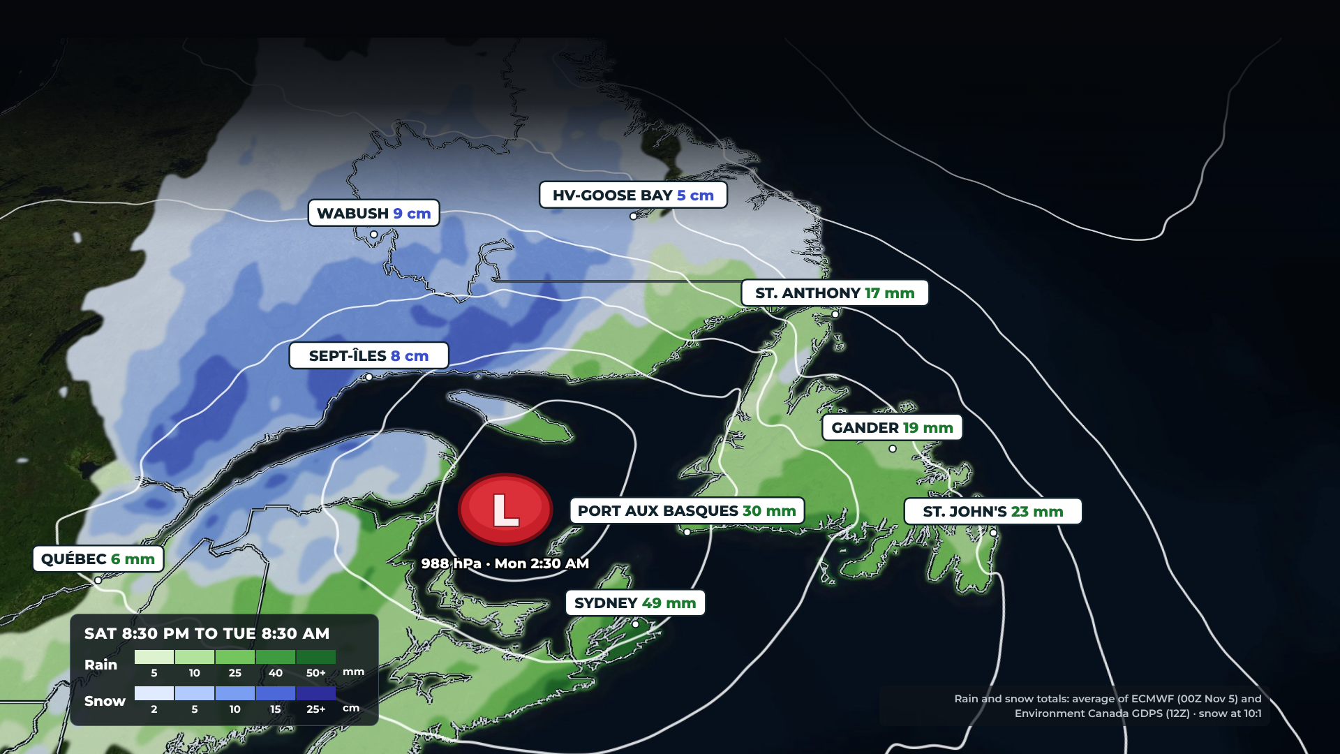
To sum it up: there’s potential for significant snow in parts of Labrador and significant to heavy rain across parts of Newfoundland. This is a very early look, and it will likely change. I suspect Environment Canada will issue some kind of special weather statement for this, maybe tomorrow if not today. They usually come out around 4 PM, so I’ll keep a close eye on it and pass it along if they do. Things dry out by Tuesday.
Looking ahead
Across eastern Newfoundland, temperatures cool on Sunday and warm up Monday, then it’s back to 8° Tuesday with showers and a breeze, and 7° Wednesday and Thursday. In central Newfoundland: rain Sunday at 2°, 9° Monday, 8° Tuesday with showers, 5° with showers Wednesday, and a mix of sun and cloud Thursday. Western Newfoundland sees rain and showers from Sunday into Thursday, possibly mixing with snow by Wednesday or Thursday as colder air works in.
In Labrador, the messy weather arrives Sunday night into Monday and may linger into Tuesday. The Goose Bay area sees snow, mixed with rain at times, on Monday at around 4°, while Churchill Falls sees snow or snow changing to rain. Snow or snow showers continue in the west on Monday, with a high near 0°, and linger into Tuesday before colder air moves back in Wednesday and Thursday.
Have a great Thursday evening! I’ll see you bright and early Friday morning with my next update.
Don’t forget to…
📱 Get the Sheerr Weather App in the Apple App Store and Google Play Store for my latest updates.
📺 Tune into Sheerr Weather 24, my 24-hour weather channel on YouTube.
🗺️ Check out the Map Room to see all the latest weather observations for the Province.
🎥 Check out the Provincial Highway Cams to see 👀 what’s going on around our highways.