
Watching 2 systems for late week
This forecast is sponsored by:

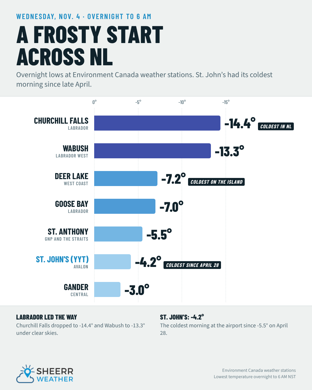
Wednesday morning was the coldest so far this fall season, with Churchill Falls falling to -14.4°. That puts it at the top, or the bottom, of the list, depending on how you want to look at it. In St. John’s, -4.2° this morning was the coldest overnight low since April 28.
Even though it was cold, it was a beautiful start to the day. The view from Torbay this morning showed sunshine, a blue ocean, a gorgeous sky and hardly a cloud to be found. Satellite and radar show that hasn’t changed much through the day for eastern and northeastern Newfoundland, but off to the west, clouds are on the increase. Further west, there’s rain spinning around an area of low pressure near Minneapolis, and that will play a role in our forecast for Thursday and Friday.
Warm air surges north
That low, now spinning east of Minneapolis, is sending some unseasonably warm air into parts of Ontario and Quebec this afternoon. Sudbury, Toronto, Ottawa and Montreal are all in the upper teens to about 20°. That warmer air is surging north, and it will bring some rain to parts of Labrador tomorrow, along with much warmer temperatures than we’ve seen over the last couple of days.
Tonight and Thursday
Tonight stays generally dry. By 5 or 6 AM Thursday, light rain, maybe briefly beginning as freezing rain, starts in Labrador City, Wabush and eastern Quebec. Over the Island, high pressure is parked overhead, and a lot of us are in for another fairly chilly night. Temperatures in the Big Land will be near freezing, central and western Newfoundland will be well below, and the east will be near or below freezing once again.
The low moves east on Thursday, keeping the rain going and pushing it east. By midday, areas from Nain to Goose Bay and back to Labrador City and Wabush are still in the rain. That’s round one. Rainfall amounts from late tonight to Thursday evening look like 10 to 20 mm from the Churchill Valley back toward Labrador City and Wabush, with lesser amounts to the east and north.
Thursday brings a nice rebound in temperatures: 6° to 8° in the Big Land, the warmest we’ve seen in a few days. Across Newfoundland, it’s cloudy in the west and southwest but sunny in the east and northeast, with highs of 6° to 8°. Warmer across the board!
Friday: rain turns to snow in Labrador
Round two comes Thursday night and Friday, and it will be decidedly more wintry. By Thursday evening, snow shows up north of Nain. That’s the rain/snow line, along with the cold front, as the wind turns north behind the low. That line crashes south overnight, and by about 9 or 10 AM Friday, rain flips over to snow in Labrador City, Wabush and Churchill Falls.
Travel between Goose Bay and Lab West is going to be very treacherous on Friday, even though it may not start that way. By midday Friday it’s snowing in Makkovik, and by 6 PM Goose Bay has flipped to snow. The rain/snow line keeps pushing east into Saturday morning before things wrap up around midday Saturday, a little later in some areas, and the skies clear out.
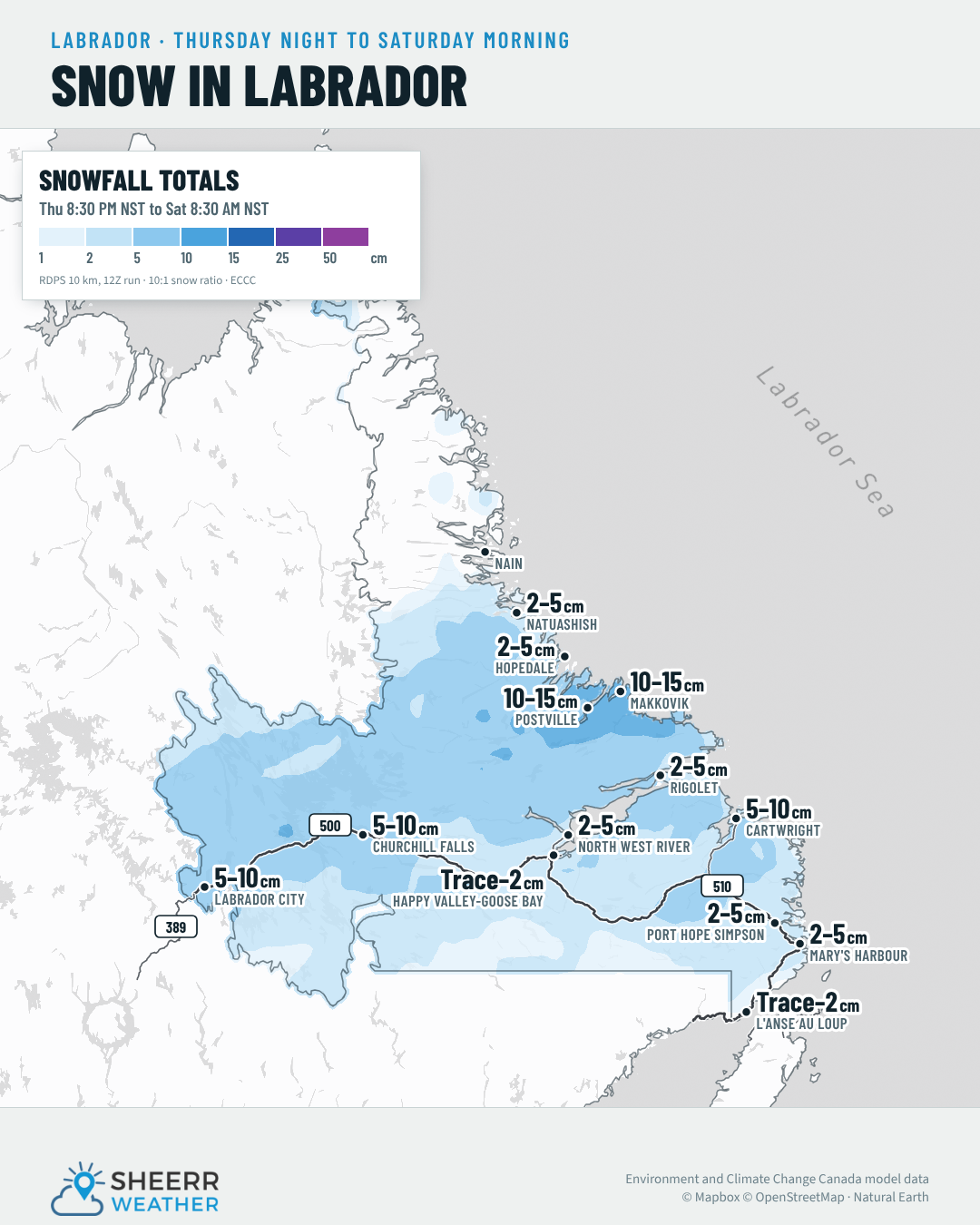
Keep in mind it’s only Wednesday, but here’s what it looks like for snowfall in the Big Land between late Thursday night and early Saturday morning:
- Postville and Makkovik: 10 to 15 cm
- Labrador City, Wabush and Churchill Falls: 5 to 10 cm
- Cartwright: 5 to 10 cm
- Rigolet, Port Hope Simpson and Mary’s Harbour: 2 to 5 cm
- Goose Bay area: a trace to 2 cm, a little more in the higher terrain and in places like North West River
In the southeast, the snow will arrive later on Friday, Friday night or even early Saturday morning, before winding down in the second half of Saturday.
Looking ahead: a soggy Sunday?
Saturday across Newfoundland looks very quiet. Sunday, on the other hand, may not be. An area of low pressure rolling up the Eastern Seaboard looks like it will bring a spell of milder temperatures to the province, along with the potential for rain, maybe even heavy rain, from Saturday night through Sunday and possibly into Monday, since it looks like it might be a slow mover. I’ll be watching it closely over the next few days, but consider this your heads-up for the second half of the weekend.
On the 7-day forecast, rain arrives late Sunday in the east, with showers for central Newfoundland and rain for western Newfoundland and the Northern Peninsula. That rain spreads east Sunday night and Monday.
In Labrador, that second system will be a bit of a mixed bag depending on where you are: rain and snow, or a rain/snow mix, in the south and the north, depending on where the warm air ends up, and snow in the west on Monday. The Goose Bay area looks like snow, potentially changing over to rain Sunday into Monday as warmer air surges north with the second low.
Lots to track, but for the next couple of days things look relatively uneventful, with just some rain in the forecast. Have a very good Wednesday evening! My Morning Briefing will be up bright and early Thursday morning.
Don’t forget to…
📱 Get the Sheerr Weather App in the Apple App Store and Google Play Store for my latest updates.
📺 Tune into Sheerr Weather 24, my 24-hour weather channel on YouTube.
🗺️ Check out the Map Room to see all the latest weather observations for the Province.
🎥 Check out the Provincial Highway Cams to see 👀 what’s going on around our highways.
Thanks for update Eddie. I don’t think we can complain with the forecast on the Island, but Labrador may feel different, unless they look forward to the snow. Thanks again!