
Wednesday Morning’s Weather Briefing — October 21, 2026
Good Wednesday Morning!
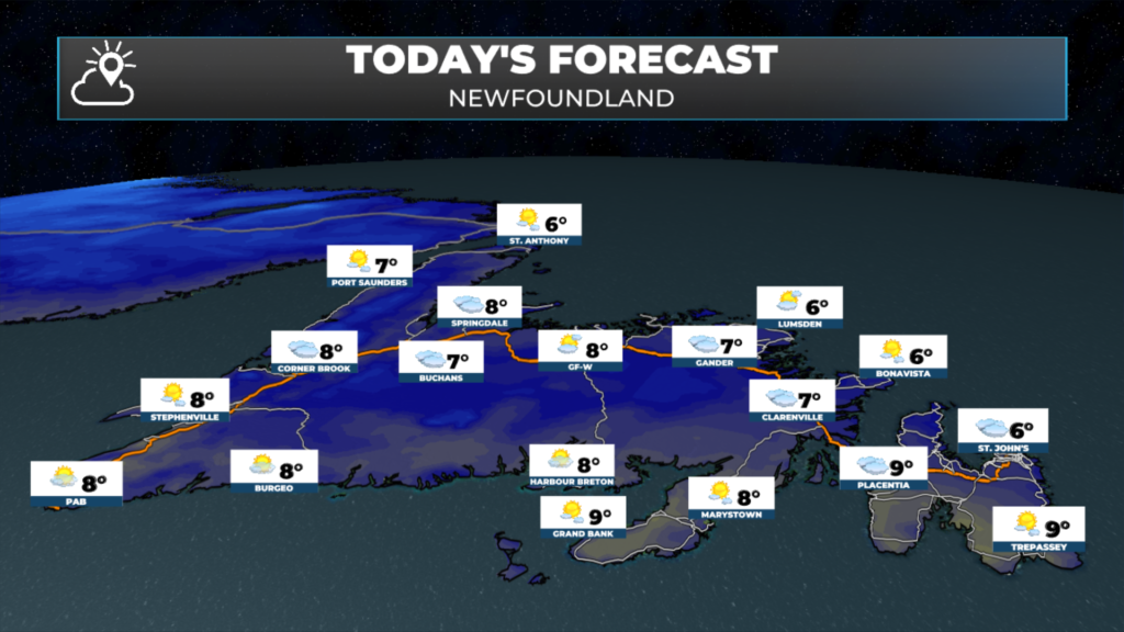
- A cool, cloudy start, with a few showers or some drizzle early this morning, then clearing this afternoon. Highs of only 6 to 9 on the Island.
- Northerly winds go light today, and skies clear this evening before clouds return overnight. Lows near 0 to +2.
- A cold start in Labrador, with temperatures below freezing and wind chills down to -8 or -9 this morning, then highs near 6 and some sunshine in central and southern Labrador.
- Rain moves onto the Burin Peninsula and the Avalon on Thursday afternoon, with 5 to 10 mm by evening.
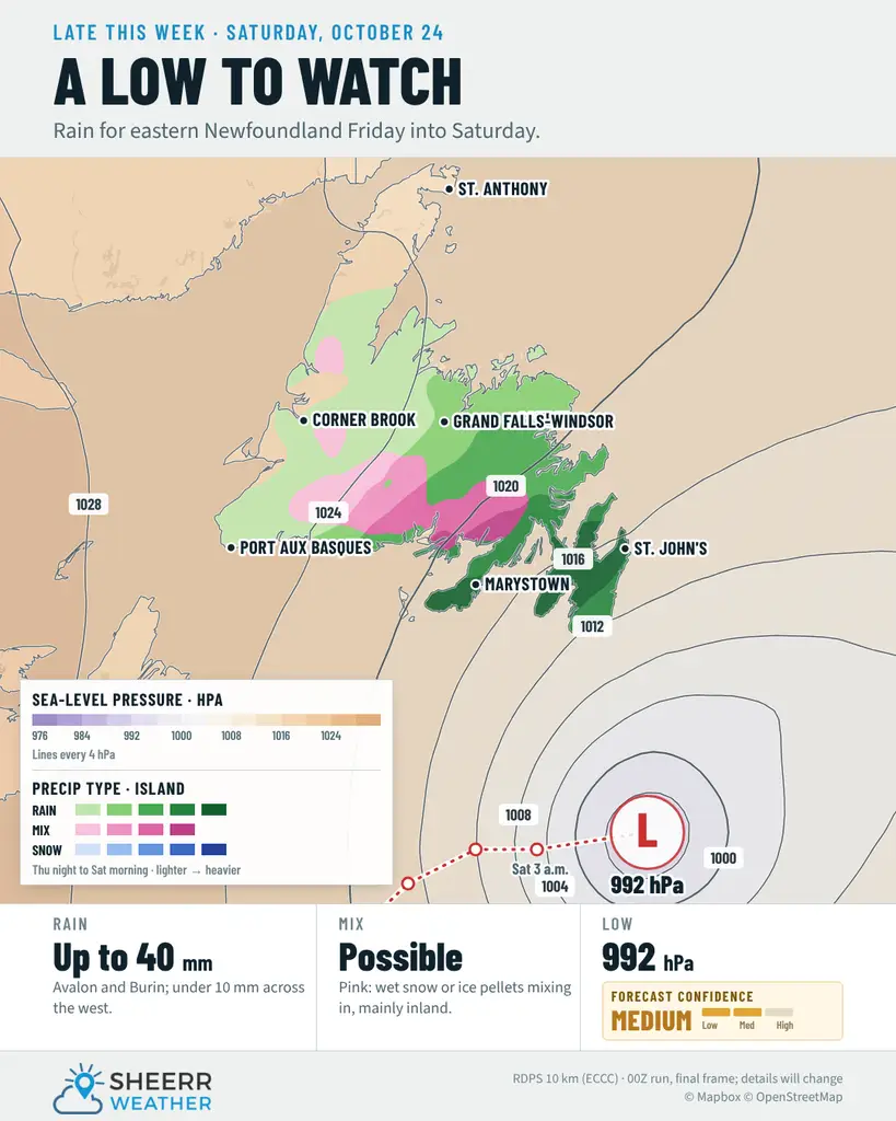
- A significant weather event is shaping up from late Thursday to early Saturday, with rain, wind and snow on Friday. The tricky part is where the snow will fall.
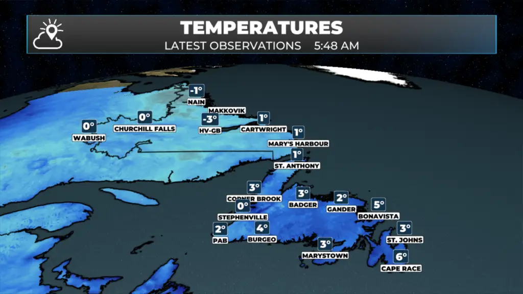
Right now: As of 5:48 this morning, temperatures are sitting just above the freezing mark across much of Newfoundland. It’s 3 in St. John’s, Marystown, Corner Brook and Badger, and 2 in Gander and Port aux Basques. Stephenville is right at 0. Coastal spots are a bit milder, with 4 in Burgeo, 5 in Bonavista and 6 at Cape Race. Labrador is colder. It’s -3 in Happy Valley-Goose Bay, with a wind chill near -8, and -1 in Nain. Wabush and Churchill Falls are at 0, and it’s 1 in Cartwright, Mary’s Harbour and St. Anthony.
It’s going to be a cooler day across the province today. Northerly winds have brought in cooler air overnight, and most of Newfoundland is starting the day under cloud, with a few showers or some drizzle around early this morning, mainly through central and eastern areas and on the West Coast. That clears out this afternoon, with more sunshine for most of the Island by the end of the day, although it will be cool, with highs of only 6 to 9. The south and southwest coasts get the best of it, with sunshine in Port aux Basques and clearing skies this morning on the Burin Peninsula.
Tonight, skies clear this evening and temperatures drop to near 0 to +2 for many areas before clouds move back in overnight. Along the southwest coast, there’s a chance of showers or drizzle and some fog patches overnight.
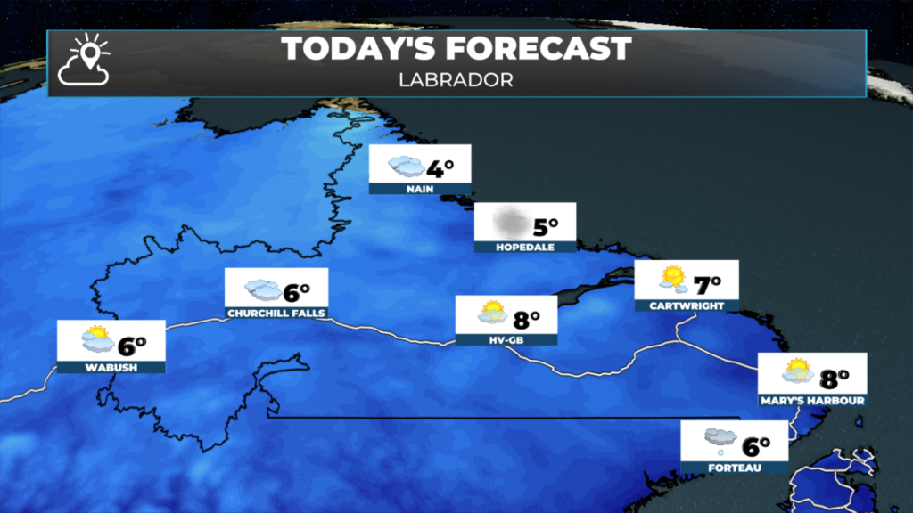
In Labrador, it’s a cold start, with wind chills near -8 in Goose Bay, Nain and Makkovik this morning. Skies are mainly sunny in Goose Bay and along the southeast coast, with highs near 6 to 7. Rain showers or flurries move into western and central Labrador this evening.
Then we turn our attention to the nor’easter, and it’s looking more significant than it did yesterday. Rain moves onto the Burin Peninsula around noon Thursday and reaches the Avalon in the afternoon, with 5 to 10 mm by evening. From there, it looks like we’re in for a significant weather event between late Thursday and early Saturday, with rain, wind and snow on Friday. The hard part right now is figuring out where the snow will fall. The models still disagree on the track, and the ECMWF model has more snow farther west than the others. Small changes in the track will make a big difference in who gets rain and who gets snow, so I’ll be watching it closely and will have a full update tonight.
Eastern Newfoundland / the Avalon: Mainly cloudy this morning, with a chance of showers or drizzle early around Clarenville, then clearing this afternoon. Highs 6 to 7. North winds 20 km/h, gusting to 40, becoming light this afternoon. A few clouds tonight, with clouds increasing overnight and lows near +1 to +2. Rain begins Thursday afternoon on the Avalon, with about 5 mm by evening, and a high near 10.
Central: Mainly cloudy, with a 40 percent chance of showers or drizzle early this morning, then clearing this afternoon. Highs near 7. North winds 20 km/h becoming light this morning. Clear this evening, then cloudy overnight, with lows near +2. Mainly cloudy Thursday, with highs near 9, then showers Thursday night.
West Coast: Cloudy, with a 40 percent chance of showers this morning, then a mix of sun and cloud this afternoon. Highs 8 to 9. Clear this evening, with clouds increasing overnight. Lows near 0 around Deer Lake and +2 in Corner Brook, rising toward 6 by morning. Thursday is mainly cloudy, with a 40 percent chance of showers or drizzle and highs of 9 to 10.
South Coast: Clearing this morning, with highs near 9. Northeast winds 20 km/h, gusting to 40, go light near noon. Clouds increase tonight, with lows of +4 to +5, and +1 inland. On Thursday, periods of rain begin on the Burin Peninsula near noon, with 5 to 10 mm. Showers or drizzle are likely toward Burgeo, with a high of 9.
Southwest / Wreckhouse: Sunny, with a high near 8 in Port aux Basques. Clouds increase tonight, with a 60 percent chance of showers or drizzle overnight and fog patches developing this evening. Southeast winds 20 km/h, gusting to 40, with a low near +5. Thursday is cloudy, with showers or drizzle and a high near 8. Winds turn northeast as the nor’easter passes Friday, so keep an eye on the Wreckhouse Wind Gauge if you’re travelling.
GNP and the Straits: Mainly cloudy this morning, with a few flurries possible early around St. Anthony, then clearing this afternoon. Highs of 6 to 7, with wind chills near -6 this morning. Clear tonight, with lows near +2, while temperatures hold near 6 around Port au Choix, with southwest winds increasing to 40 km/h, gusting to 60, overnight. Mainly cloudy Thursday, with highs of 7 to 8.
Labrador / the Big Land: A cold start, with temperatures below freezing and wind chills near -8 this morning. Lab West is mainly cloudy, with a high near 6. Churchill Falls sees a mix of sun and cloud, with a high near 6. Goose Bay is sunny, with a high near 6. Along the southeast coast, it’s mainly sunny, with highs of 7 to 8. On the North Coast, a mix of sun and cloud, becoming cloudy this afternoon, with a high near 5 in Nain. A few rain showers or flurries move into western and central Labrador this evening, with lows near 0 to +2. Thursday is cloudy, with a chance of flurries or rain showers and highs of 1 to 3 in the west, and near 6 to 7 in the east.
Looking ahead: The nor’easter is the big story for the end of the week. From late Thursday to early Saturday, it looks like a significant event for Newfoundland, with rain, wind and snow on Friday. The heaviest rain looks most likely on the Avalon and Burin Peninsula, while central and western areas, where highs are only 3 to 6 on Friday, are where snow is more likely. Exactly where the rain changes to snow, and how much snow falls, is still uncertain. The ECMWF model is farther west with the snow than the others, so if you’re in central or western Newfoundland, keep an eye on the forecast over the next day or so. Things improve from west to east on Saturday, with sunshine returning to western and central Newfoundland while showers linger in the east. Labrador stays quiet and turns milder by the weekend, with highs near 10 in Goose Bay by Saturday.
📱 Get the Sheerr Weather App in the Apple App Store and Google Play Store.
📍 Want more detail for where you live? Check out our new Regional Forecast pages for current conditions, local alerts, highway cams and the forecast for your area: Avalon · Eastern · Burin Peninsula · South Coast · West Coast · Long Range Mountains · Central · GNP & the Straits · Labrador West · Central Labrador · Labrador North Coast · Labrador South Coast
🗺️ Check out the Map Room to see all the latest weather observations for the Province.
🎥 Check out the Provincial Highway Cams to see 👀 what’s going on around our highways.