
Winter Storm, Snowfall, Rainfall, Wind Warnings, Along With Special Weather Statements in Effect for Monday
Another round of snow, rain and wind is on tap for much of Newfoundland Monday, as yet another strong area of low pressure will pass through our region of the North Atlantic. As this approaches and moves through, snow and rain will spread across Newfoundland overnight and that will continue through much of Monday. A period of high winds will accompany this low, and like the last few, the peak of the wind will occur as the low is pulling away Monday afternoon and evening.
Ahead of this storm system, the Environment and Climate Change Canada Weather Office in Gander has issued Winter Storm, Snowfall, Rainfall and Wind Warnings for various areas of the Island, along with two Special Weather Statements. They are listed below.
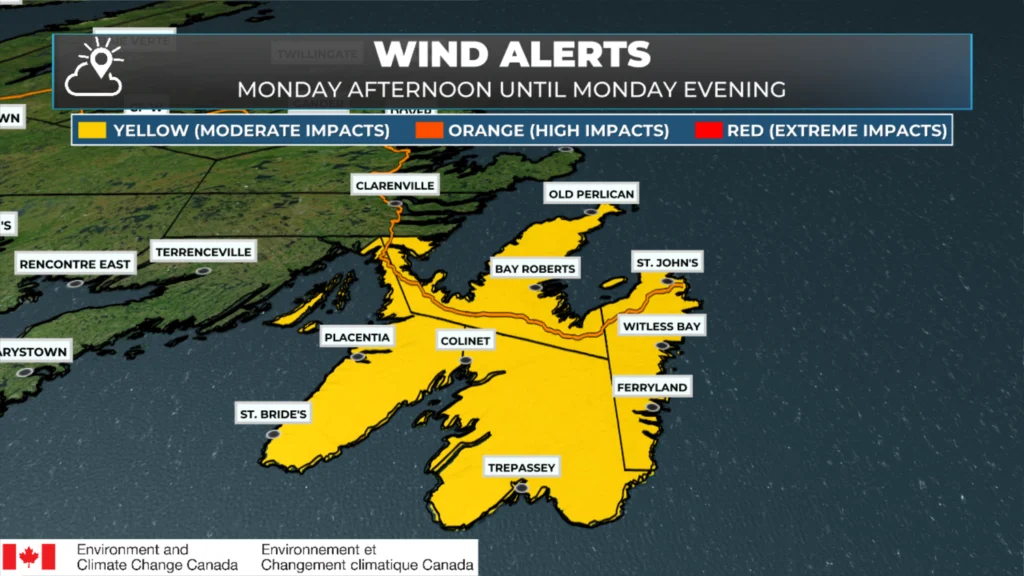
A Wind Warning (Yellow Level) is in effect for the following areas from Monday afternoon until Monday evening:
Avalon Peninsula North
Avalon Peninsula Southeast
St. John’s and vicinity
Avalon Peninsula Southwest
Maximum Wind Gusts: 100 km/h from the southwest.
The strongest wind speeds are likely to occur along the coast. Local utility outages are possible. Damage to roofs, fences, branches or soft shelters is possible. Wind Warnings are issued when there is a significant risk of damaging winds.
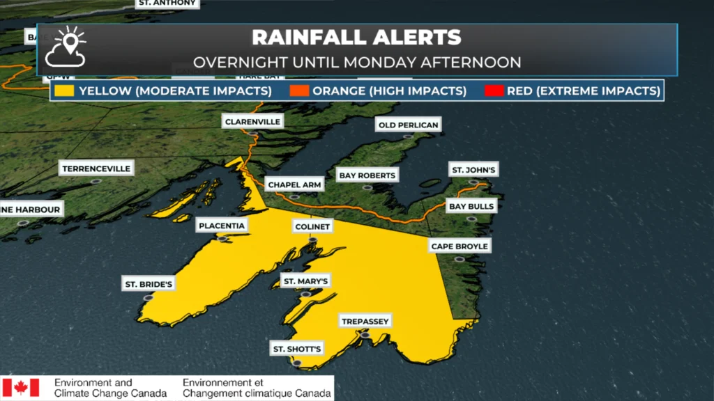
A Rainfall Warning (Yellow Level) is in effect for the following areas from overnight tonight until Monday afternoon:
Avalon Peninsula Southeast
Avalon Peninsula Southwest
Rainfall Amount: 25 to 40 mm
Rain will arrive overnight and will continue into Monday afternoon. Water will likely pool in low-lying areas and on roads. Rainfall Warnings are issued with significant impacts expected due to rainfall amounts.
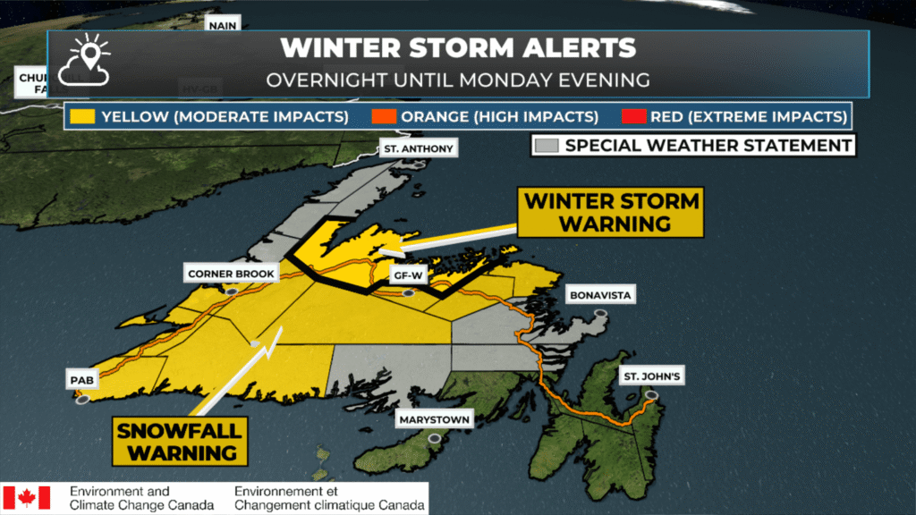
A Winter Storm Warning (Yellow Level) is in effect for the following areas from overnight tonight until Monday evening for the following areas:
Bay of Exploits
Green Bay – White Bay
Total Snowfall: 15 to 25 cm
Maximum Wind Gusts: 70 km/h from the northeast.
Snow will begin overnight tonight, with conditions deteriorating further on Monday as strong northeast winds develop, resulting in widespread blowing snow. Snowfall rates of 3 to 5 cm per hour are possible, producing locally higher amounts under heavier bands.
Travel will likely be challenging. Visibility will likely be suddenly reduced to near zero at times.
Winter Storm Warnings are issued when multiple types of severe winter weather (such as snow, freezing rain, wind and rain) are expected or occurring.
A Snowfall Warning (Yellow Level) is in effect from overnight tonight until Monday evening for the following areas:
Burgeo – Ramea
Channel – Port aux Basques
Corner Brook and vicinity
Deer Lake – Humber Valley
Bay St. George
Buchans and the Interior
Grand Falls-Windsor and vicinity
Bonavista North
Gander and vicinity
Total snowfall: generally near 15 cm except 15 to 25 cm for central Newfoundland.
Snow will develop overnight tonight then become heavy at times on Monday. Strong winds on Monday will result in reduced visibility in blowing snow over exposed areas. Snowfall rates of 3 to 5 cm per hour are possible over some areas.
Travel will likely be challenging. Visibility will likely be reduced at times.
Snowfall warnings are issued when significant impacts are expected due to snowfall accumulations.
A Special Weather Statement is in effect for the following areas from overnight tonight until Monday evening:
Gros Morne
Northern Peninsula East
Parson’s Pond – Hawke’s Bay
Port Saunders and the Straits
Snowfall Amounts: 5 to 10 cm, except 10 to 15 cm over eastern sections of the Northern Peninsula.
An approaching low pressure system will bring snow to the region. Strong winds Monday afternoon will result in reduced visibility in blowing snow for many areas.
Snow accumulations may make travel hazardous. Roads and walkways could become slippery and difficult to navigate. Consider adjusting plans to avoid the most adverse conditions.
A Special Weather Statement is in effect for the following areas from overnight tonight until Monday afternoon:
Bonavista Peninsula
Clarenville and vicinity
Terra Nova
Connaigre
A developing low pressure system will bring a variety of wintry precipitation to the region. Snow will begin overnight tonight then change through ice pellets and freezing rain to rain on Monday.
Accumulations of snow and ice may create slippery and hazardous travel and walking conditions. Rain may lead to pooling of water and localized flooding. Ensure storm drains are clear of ice and other debris in advance of the wintry weather.
I’ll have my next update posted this evening for Monday!
📱 Get the Sheerr Weather App in the Apple App Store and Google Play Store.
🗺️ Check out the Map Room to see all the latest weather observations for the Province.
🎥 Check out the Provincial Highway Cams to see 👀 what’s going on around our highways and byways!
Thank you for the update. Really appreciate the breakdown of all the areas.
Thanks Eddie. We can always count on you to keep us well informed.
Thanks Eddie for the updates!
Thanks for weather update Eddie
Good Morning Eddie!
….. and so it continues! That wind!! I’ve never seen high winds like this before. Thanks for keeping us updated!
To be clear, the Burin Penn has no alerts? I don’t mind not being invited to this party, just making sure.
Thanks for your detailed weather. My go to every day
Thanks Eddie!
You’re the very best!
Thanks for keeping us informed and safe!
Thanks for the update Eddie !
Eddie do you have any insight on our powerful winds this past several weeks? I’ve not seen this in my lifespan of 60+ all at once.
Thanks for the update , grately appreciated, stay safe