
Wednesday Morning’s Weather Briefing — September 30, 2026
Good Wednesday Morning! Here are today’s highlights
The drizzly, foggy weather many areas are seeing in the east, central, and north will ease later this morning, and there will be some clearing.
Highs reach the teens on the Island and teens to near 20ºC in Labrador.
Thursday sees nicer weather on the Island while showers arrive in Labrador West late in the day.
This morning’s update is sponsored by Roebothan, McKay, Marshall.

Visit MakeTheCall.ca today to learn more about how the law firm can help you!
We wrap up September on a mild, quiet note, but a grey one. Temperatures are in the single digits to low teens to start the day (6 to 8 in Labrador and on the Northern Peninsula, 10 to 12 on the Island), and cloud is stuck over almost all of us. There’s light rain around Gander this morning, low cloud and fog on the Northern Peninsula and parts of the Avalon, and not much wind.
Showers and fog patches will wind down on the Avalon and across Central this morning, and we should see some sunny breaks later in the day. The Southwest and South coasts hang on to the grey stuff the longest, with a risk of drizzle and gusts near 40 km/h early. Thursday looks mostly cloudy with a few peeks of sun and nothing major.
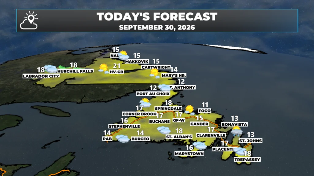
Here’s what to expect today:
Eastern Newfoundland and the Avalon: highs 13 to 15. A 20% chance of a shower early, then some sun. Coolest right along the water where the fog linger through the morning, followed bh clearing this afternoon.
Central: highs 14 to 16, with a 40% chance of morning showers this morning. Warmest inland, coolest along the Northeast Coast.
West Coast: highs 15 to 17, with a 15 to 30% chance of a morning shower, then clearing.
South Coast: highs around 14 to 16 and cloudy, with a 25% chance of drizzle. Fog is possible near the water.
Southwest Coast + Bay St. George: highs 13 to 15, cloudy and a bit breezy, with a 15% chance of a shower.
GNP and the Straits: highs 11 to 13, cloudy and slow to warm, with low cloud and fog hanging around the coast.
Labrador: the Big Land is mostly dry today. Goose Bay is the warmest, with highs near 20; Labrador West around 16 to 17; and the North Coast near 14 to 15. Showers reach Labrador West on late Thursday.
Have a great day and follow along for updates! My detailed forecast will be posted this afternoon.
📱 Get the Sheerr Weather App in the Apple App Store and Google Play Store.
🗺️ Check out the Map Room to see all the latest weather observations for the Province.
🎥 Check out the Provincial Highway Cams to see 👀 what’s going on around our highways and
Good Morning Eddie!
Not too bad a forecast for last day of September! Annuals are showing their age 🙃. Thanks for update. Have a good day.
Good morning Eddie thanks for the update