
Wednesday Morning’s Weather Briefing — July 8, 2026
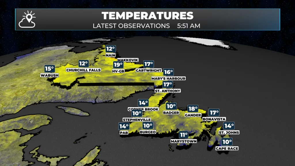
Temps across NL as of just before 6:00 AM NDT
Good Wednesday Morning! Here are some highlights on the day(s) ahead:
The hottest day of the year is likely to occur today across much of the Province under a ridge of high pressure.
Temperatures reach the mid- to upper 20s to near 30 ° on the Island, and the upper 20s to lower 30s in the Big Land.
There will be scattered showers and thunderstorms this afternoon in Labrador.
Skies will be hazy once again due to wildfire smoke aloft (mostly) from the fires burning in Quebec and Labrador.
The heat breaks overnight as a pattern change sweeps through the region.
This morning’s update is sponsored by Roebothan, McKay, Marshall.

Visit MakeTheCall.ca today to learn more about how the law firm can help you!
Newfoundland
Today’s the one — the hottest day of the year so far is playing out across most of the Island as a strong ridge of high pressure parks itself overhead. Expect highs in the mid- to upper 20s, with some spots pushing right up near 30°, especially well inland and away from any sea breeze relief along the coast. If you’re out enjoying it, know that the sky won’t be that crisp summer blue — it’s hazy again today, courtesy of wildfire smoke riding in aloft from fires burning up in Quebec and over in Labrador. It shouldn’t affect surface air quality much, but it’ll take the edge off the sunshine and give everything that smoky, washed-out look. The good news for anyone not a fan of the heat: it doesn’t last. A pattern change moves through overnight, and that ridge gets shoved out of the way, bringing temperatures back down to something more seasonable by tomorrow.
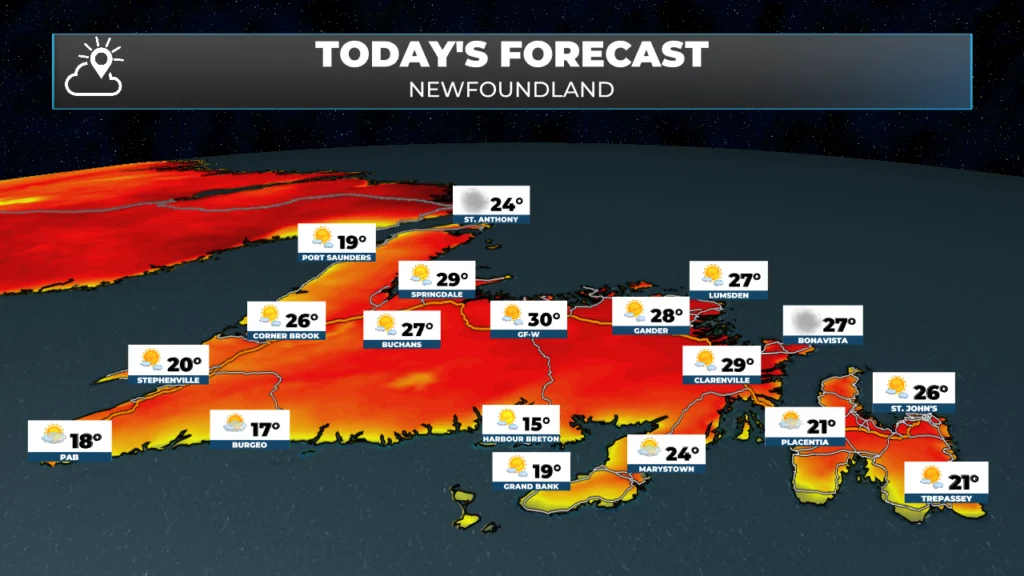
Newfoundland’s forecast for today — July 8, 2026
Labrador
Labrador is right in on the heat too, and honestly running even warmer than the Island — highs in the upper 20s to low 30s under that same building ridge. Unlike the Island though, this heat comes with some payback: scattered showers and thunderstorms are expected to fire up this afternoon as the atmosphere gets loaded with heat and enough moisture, so keep an eye to the sky if you’re out and about, particularly through central and western Labrador. Smoke haze is thick here too — Labrador’s dealing with fires burning closer to home in addition to the smoke drifting down from Quebec, so don’t be surprised if the sun looks dim or orange through the haze. Like the Island, this won’t stick around — a pattern change sweeps through overnight and breaks the heat, so today is very much the peak before things turn more comfortable. The pattern change should reduce the smoke in the air, but by how much is what I’m uncertain of.
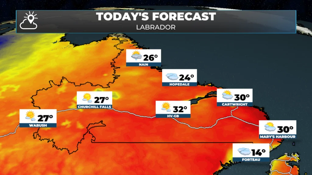
Labrador’s forecast for today — July 8, 2026
Today’s Fire Hazard Index
The Canadian Wildland Fire Information System Fire Weather Index shows parts of Newfoundland and Labrador in the ‘very high’ category for today. The Fire Weather Index (FWI) rates how intense a wildfire would likely become if one started, based on recent and forecast weather — temperature, humidity, wind, and rainfall. It doesn’t predict whether a fire will start; it tells us how hard one would be to control. In the Low and Moderate zones (blue, green), fires generally stay small and manageable. High and Very High (yellow, tan) mean fires can spread quickly and demand aggressive response, while Extreme (red) means any new fire could grow explosively, with flames too intense for direct attack. The index comes from the Canadian Wildland Fire Information System and is the same system fire agencies use for daily preparedness across Canada. For existing fires, the high values indicate potential for growth, particularly for uncontrolled fires.
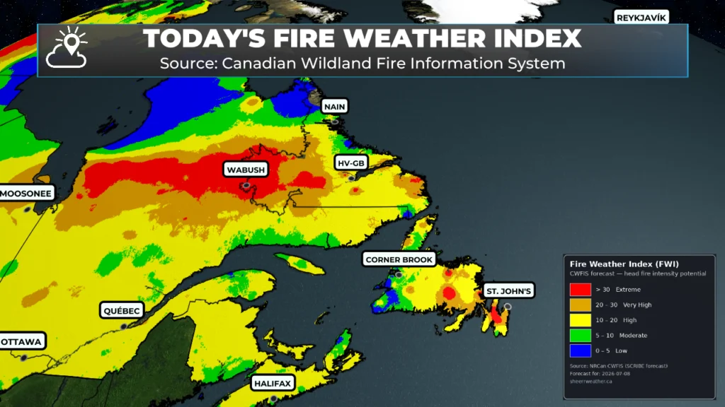
Today’s Fire Weather Index from CWFIS.
The Provincial index (updated Tuesday afternoon) shows the Avalon and Beothunk Lake areas as Very High and the Burin Peninsula as EXTREME. Based on the CWFIS chart, I suspect more of the Island will be under ‘VERY HIGH’ in the Provincial update coming out this afternoon.
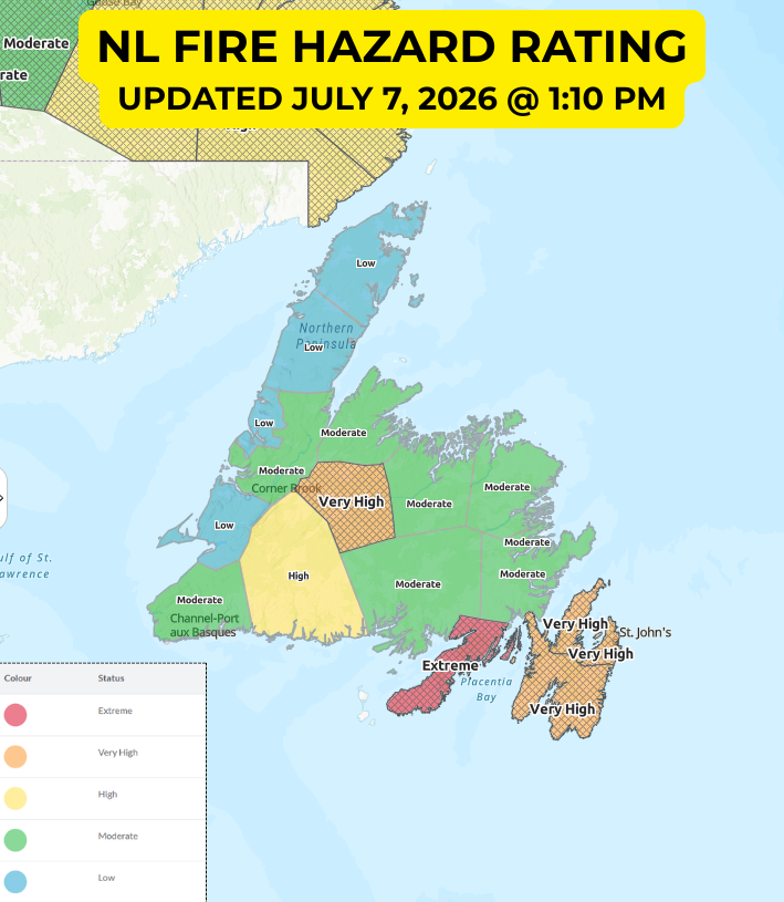
The Provincial Fire Hazard Rating is issued early in the afternoon. THis is from yesterday – July 7, 2026.
Keep in mind these are different products. In my opinion, it’s very important to NOT have any open fires today if you’re in an area rated as high to extreme on the CWFIS map above. The combination of heat and dry air makes fire danger very high in many areas today. Remember, there is currently a fire ban in Labrador due to the ongoing wildfires. Find the Provincial info here.
My next update will be posted later today!
📱 Get the Sheerr Weather App in the Apple App Store and Google Play Store.
🗺️ Check out the Map Room to see all the latest weather observations for the Province.
🎥 Check out the Provincial Highway Cams to see 👀 what’s going on around our highways and
Good morning Eddie another beautiful day, enjoy