
Wednesday Morning’s Weather Briefing — April 22, 2026
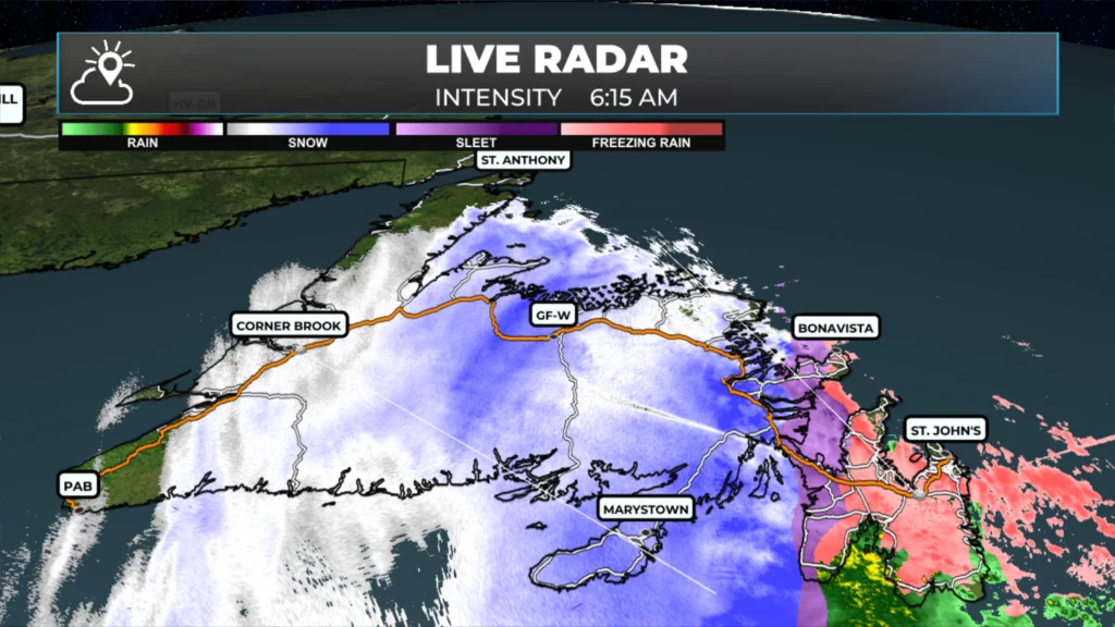
A radar snapshot from 6:15 AM showing the snow, ice and freezing rain across Newfoundland.
Good Wednesday morning!
Here are today’s weather highlights:
Yellow Level Freezing Rain and Snowfall Warnings are currently in effect for much of Newfoundland. The exception is the West Coast, South Coast and Southwest Coast. The southern coast of Labrador is also under a Yellow Level Snowfall Warning. Find the latest alerts here.
Freezing drizzle, freezing rain and snow are currently falling across much of the Island. As of 5:48 AM, the rain/snow line seems to be situated from near Terra Nova southward to the middle of Placentia Bay. Webcams don’t offer much help just yet!
The Avalon will see the freezing rain change to rain this morning, and the rain will last through the day. Areas from just west of Gander, to the West Coast and GNP will see snow through most of the day. There will be an area of ice pellets and freezing rain between.
Southeast Labrador and the coast will see the snow arrive later this morning, before transitioning to ice pellets and freezing rain and eventually just rain overnight. Snow pushes into central and western Labrador overnight into Thursday.
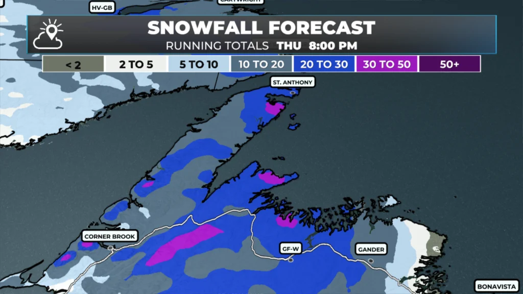
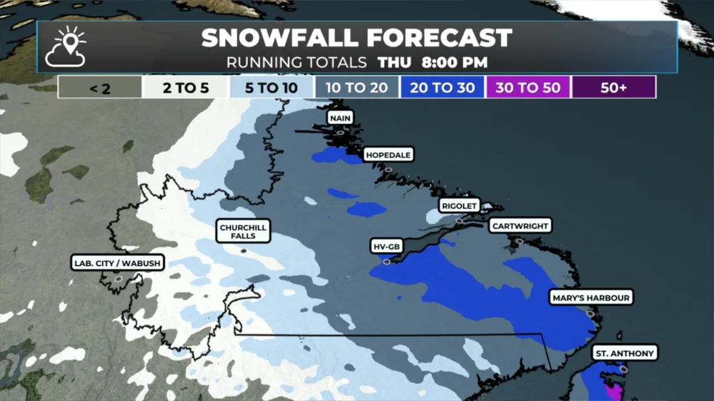
Scroll through these images to see how much ice and snow is in the forecast for your area between now and later today/tonight.
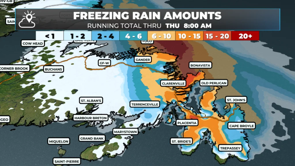
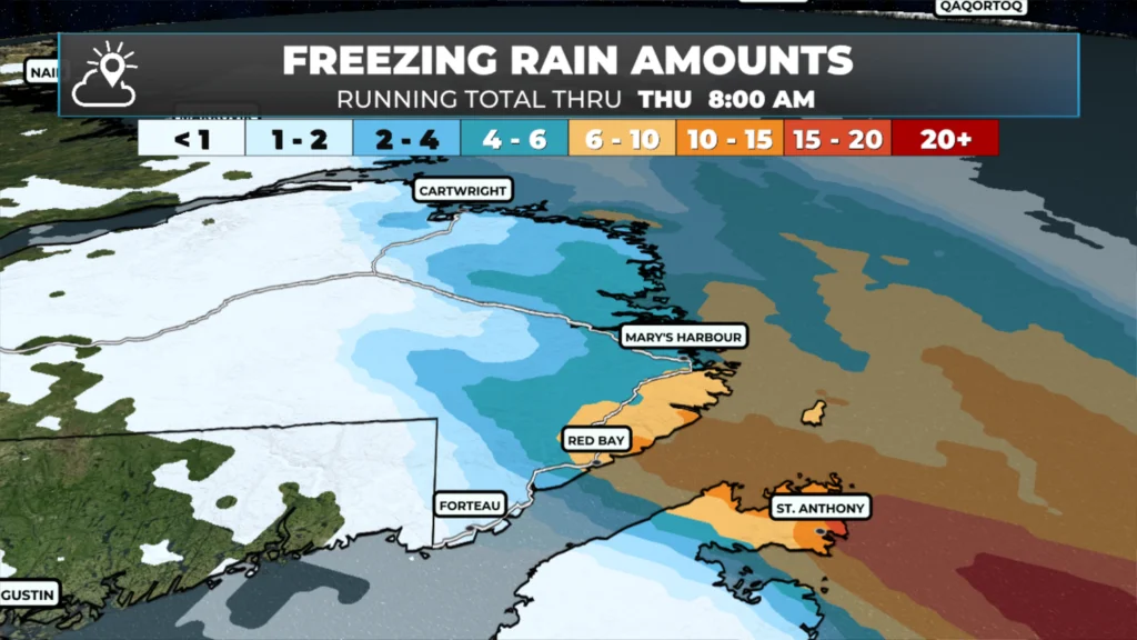
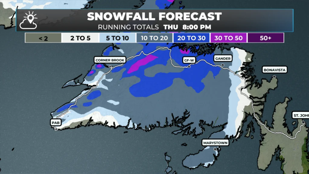
Freezing drizzle, freezing rain, and snow are falling across much of the Island as I type this. As of 6 AM, the radar indciated rain/snow line looks to be draped from around Terra Nova southward to the middle of Placentia Bay. Everything east of that line is dealing with freezing rain, freezing drizzle, or a cold rain along parts of the immediate coast. Everything west of it is snow, ice pellets or a mix of both. The webcams aren’t offering much help at this hour — it’s still kind of dark and the precip is doing a good job of obscuring things.
Today’s Outlook
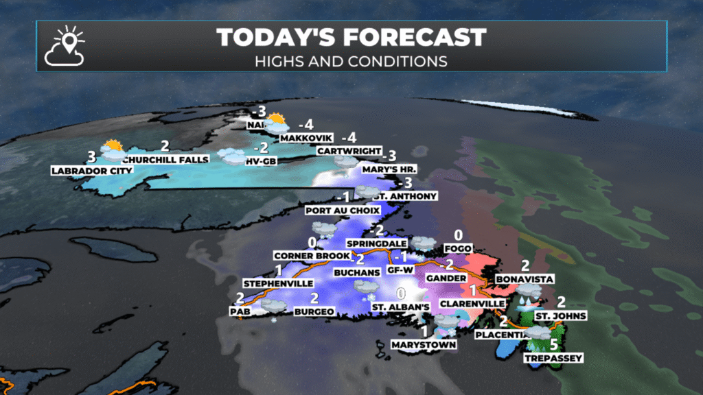
Today’s forecast for NL | April 22, 2026
The Avalon is the area I’m watching most closely this morning. Easterly winds off the ocean should start to chew away at the cold layer through the morning, and that freezing rain will change over to plain rain as temperatures climb above zero. The southern shore and Metro will likely be the first to flip, followed by the Avalon North and the southwest. Once the changeover happens, it’s just a wet, raw day — but at least the ice threat ends. Expect rain, on and off, right through the day and into this evening.
The Bonavista Peninsula and Clarenville and Bonavista Bay area are in a similar boat, but the freezing rain hangs on a little longer — possibly into the afternoon before the warmer air finally wins out. The community of Terra Nova may see the freezing rain and/or ice pellets last substantially longer.
From near/west of Gander, through to the West Coast and the GNP, it’s snow or snow mixed with ice pellts through most of the day. Gander will see a change to freezing rain this morning. To the west, and perhaps away from the immediate coast, is where the heaviest accumulations on the Island are going to pile up. Central and western/northwestern Newfoundland could see 15 to 20+ cm out of this before things wind down, with the higher terrain getting the upper end. It’s not a cold system, so the snow is going to be wet and heavy — the kind that sticks to everything and weighs down branches and power lines. Keep that in mind.
In between — think Gander, Twillingate, the northeast coast — you’re in the messy transition zone. That means ice pellets and freezing rain through much of the day before a possible changeover later. It’s the worst of both worlds, honestly: not enough snow to shovel nicely, but enough ice to make everything treacherous.
Labrador will see the snow arrive this afternoon in the southeast and push north. This evening or tonight, the snow will mix with ice pellets and freezing rain along the coast, before changing to rain by Thursday morning.
Tonight
On the Avalon and eastern Island, the rain continues through the evening before tapering off overnight. The big story tonight shifts to southeastern Labrador and the coast, where snow arrives later this morning and then transitions to ice pellets and freezing rain through the evening, before eventually becoming just rain overnight as warmer air pushes in. It’s the same progression we’re seeing on the Island today, just shifted several hours to the north.
Central and western Labrador get in on the action overnight into Thursday as the snow pushes inland. This is where it stays all snow — Labrador City, Wabush, Churchill Falls — and accumulations into Thursday should be significant.
Tomorrow (Thursday)
Island-wide, Thursday is recovery day. Lingering showers and flurries in spots, especially for the west coast and GNP. It does appear as though large chunk of the Island, including the Avalon, will see some sunshine by the afternoon.
Labrador keeps the snow going through much of Thursday, particularly for central and western areas, before things start settling down later in the day. Southeastern Labrador flips back to whatever scraps are left of the system after the overnight rain.
The Bottom Line
Avalon/Bonavista: Ice this morning → rain the rest of the day. Travel could be rough until the changeover completes.
Central & western NL + GNP: Snow all day, wet and heavy, 15–20+ cm in the hardest-hit spots.
Transition zone (roughly Gander to Twillingate): The worst mix — ice pellets and freezing rain, possibly for hours.
Labrador: Snow building in later today, with central and western areas seeing the brunt overnight into Thursday.
Check in again later this morning for an update once the webcams start picking things up better.
📱 Get the Sheerr Weather App in the Apple App Store and Google Play Store.
🗺️ Check out the Map Room to see all the latest weather observations for the Province.
🎥 Check out the Provincial Highway Cams to see 👀 what’s going on around our highways and
Good morning Eddie thanks for the update, have a wonderful day
Thanks for the update Eddie! Have a great day
Good morning Eddie, thanks for the update. Have a great day.
I’m pretty sure I’m hearing thunder in the last 1/2 hr.