
Wednesday Morning Weather Update — December 31, 2025
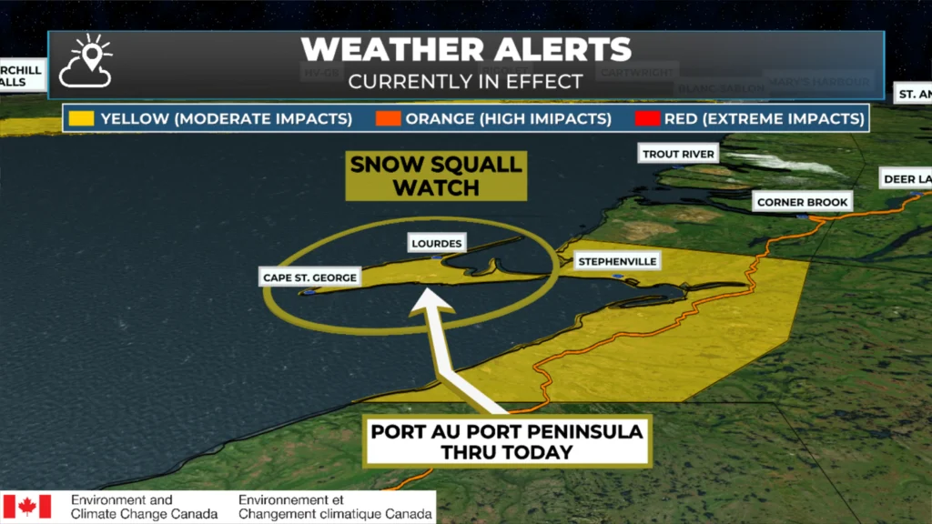
Snow squall watch for today – December 31, 2025 – issued by Environment and Climate Change Canada.
Good Wednesday Morning!
Here are today’s weather highlights:
A calmer day is in store for most of Newfoundland & Labrador as we close out 2025.
Some light rain and snow will move over the Avalon this morning into the early afternoon. Locations inland and over higher terrain will pick up a couple centimetres of wet snow.
A Yellow Watch for Snow Squalls is in effect today for Bay St. George and the Port au Port Peninsula, more specifically. Amounts in squalls may reach 10 cm, with locally higher amounts likely.
Areas of the West Cast, specifically the western side of the Northern Peninsula along Route 430, should also see snow squalls this afternoon, which may make driving difficult later today.

This update is sponsored by Roebothan, McKay, Marshall.
Visit MakeTheCall.ca TODAY to learn more about what the law firm can do for you.
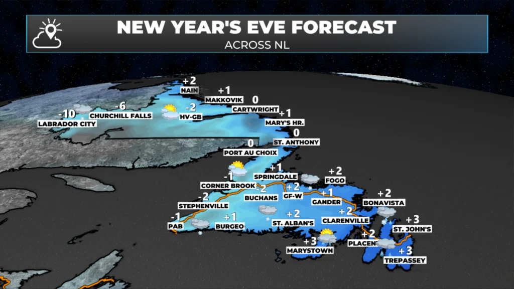
Today’s forecast (Dec. 31, 2025) for Newfoundland & Labrador.
The weather across Newfoundland and Labrador will be much calmer today. While it will not be completely quiet, I am only expecting flurries across much of Labrador, with a few flurries and/or snow squalls over parts of southern and western Newfoundland. As mentioned above, a Yellow Watch for Snow Squalls is currently in effect for the Bay St. Gerooge area, with a focus on the Port au Port Peninsula. Those same snow squalls will brush the western side of the Great Northern Peninsula this afternoon, and may make for some difficult driving in spots along Route 430.
The other area of semi-active today will be the Avalon Peninsula and possibly the Burin and Bonavista Peninsulas, where light snow and/or rain will move through between roughly 8 AM and 2 PM. Expect up to 5 cm of wet snow inland and over higher terrain as this moves through. This shouldn’t affect New Year’s Eve celebrations.
Future satellite and radar imagery shows how the precipitation plays out across the Island and parts of Labrador today.
Once that area of rain and snow departs, as shown above, we will see very little rain and snow across the Province as we head into the later stages of today and tonight. Even the wind speeds will relax! This should set the stage for any/all New Year’s celebrations across the region to go off unimpeded by weather. The City of St. John’s will be having their annual fireworks display at Quidi Vidi Lake tonight at 8 PM. The forecast below shows the expected temperatures (big number) and wind chill (small number). We’ve certainly seen worse over the years!
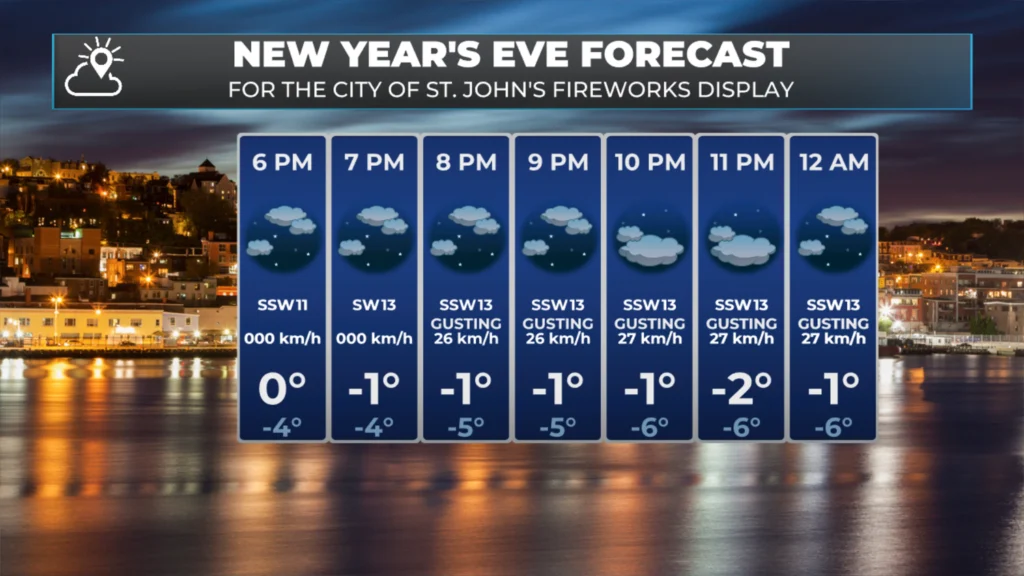
This evening’s forecast for the St. John’s Metro area – December 31, 2025.
The weather will be a bit more active across the Island tomorrow as another wave of low pressure moves through. This will bring 5 to 15 cm of snow to much of the eastern half of Newfoundland, WEST of the Avalon Peninsula. On the Avalon, we will see rain or a rain/wet snow mix. This moves in late morning and exits mid to late afternoon.
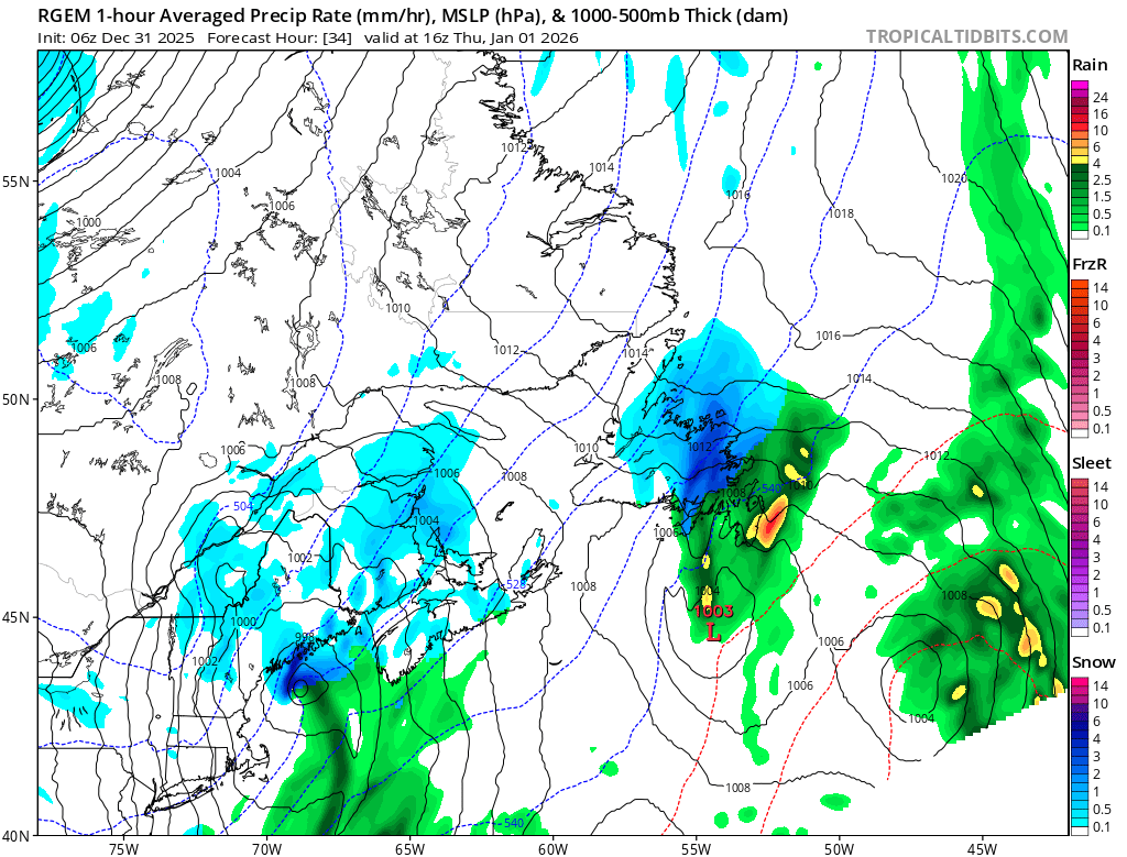
RDPS Weather model’s depiction of tomorrow’s (Jan. 1, 2026) weather across the region at 12:30 PM.
I’ll post my next update later today, which will provide more detail on the above.
📱 Get the Sheerr Weather App in the Apple App Store and Google Play Store.
🗺️ Check out the Map Room to see all the latest weather observations for the Province.
🎥 Check out the Provincial Highway Cams to see 👀 what’s going on around our highways and
Thanks for the weather update Eddie and wishing you and your family a very Happy New Year 🥳🎉🥂 Happy 2026 Newfoundland and Labrador 🥳🎉💥💥 ( Please Don’t Drink And Drive )
Happy New Year Eddie
Good morning Eddie thanks for keeping us updated and wishing you and your family Happy New Year 🥳
Thanks for the update, Happy New Year
Thank you for the update, Eddie. Wishing you and your family all the best in 2026
Good Morning Eddie! Thanks for this update, actually it looks somewhat favourable for Avalon North.
Happy New Year to you and your family. May 2026 treat you kind!
Good morning Eddie, thanks for weather update.
Good morning Eddie, thanks for the update. Happy New Year to you and your family. Have a great day.
Happy New Year to you and your beautiful family Eddie.
Happy New Year to you and your family. Thanks for the detailed forecasts.
Thank you for your continuous updates, happy new yearcto you and your family
Happy New Year to you and yours.
Thanks for keeping us posted.