
Wednesday Morning Weather Brief — October 22, 2025
Good Wednesday morning! Here are today’s weather highlights:
Temperatures will again be unseasonably warm across the Province, with highs in the teens for most areas.
There will be scattered showers for most areas, with some rain expected in parts of southeastern Newfoundland, particularly around the Burin Peninsula and the Connaigre Peninsula.
Areas of dense fog will be found along and near south-facing shores.
Tropical Storm Melissa continues to churn in the Atlantic south of the Dominican Republic and Haiti. Melissa may strengthen into a Hurricane within the next couple of days. The track of the storm will be determined by how much it strengthens.
This morning’s update is sponsored by Roebothan, McKay, Marshall.

Visit MakeTheCall.ca today to find out what the law firm can do for you!
An area of low pressure will swirl its way from northern Maine into Quebec today, putting much of the region in a broad southerly flow. This setup will bring another day of unseasonably warm temperatures to much of Atlantic Canada. High temperatures across NL will peak in the teens for most areas, and record highs may be set once again. This will be especially true in Labrador, where the average high this time of year is about 4ºC.
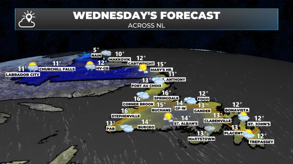
There will be some scattered showers around today as well on the east side of the low, along with an area of steadier rain near the Burin Peninsula. Rainfall amounts today, for most areas, will not be significant. And I know that is news most do not want to hear, as many communities need a vast amount of rainfall to make up for the drought we find ourselves in. The animation below will show the timing of the arrival of the showers today.
It does look like parts of the Island and Labrador will see rain between Thursday and Friday, and some of it may be significant. I’ll have a more detailed look at this forecast later today and will pass along an update if needed.
In the tropics, Tropical Storm Melissa continues to swirl south of the Dominican Republic and Haiti this morning. Melissa should remain a tropical storm for the next couple of days, per the NOAA National Hurricane Center. The current forecast indicates Melissa will track toward the Dominican Republic and Haiti. If you have travel plans to this area within the next few days, pay attention to the forecasts. At the very least, heavy rain and gusty wind speeds are expected as the storm nears that area and possibly Jamaica by Thursday.
Stay tuned for more weather updates.
I’ll have my next update posted later today or Thursday morning.
📱 Get the Sheerr Weather App in the Apple App Store and Google Play Store.
🗺️ Check out the Map Room to see all the latest weather observations for the Province.
🎥 Check out the Provincial Highway Cams to see 👀 what’s going on around our highways and byways!
Thanks Eddie for weather update
Thanks Eddie.
Thanks Eddie.have a wonderful day
Keep up the good work Eddie