
Wednesday Morning Weather Brief — November 19, 2025
Good Wednesday Morning!
We are starting the day with cool temperatures and scattered showers and/or flurries across the Island. The most widespread activity is over western areas, with more isolated showers found farther east over the Burin and Avalon Peninsulas. Some showers are brief and may even contain a bit of graupel!
Temperatures as of 6 AM NST range from the single digits above freezing to the single digits below freezing across the Province. The coolest readings are in Labrador West. Speaking of Labrador West, Wabush Airport has been reporting snow for 33 consecutive hours in the hourly observations! That should end sometime today.
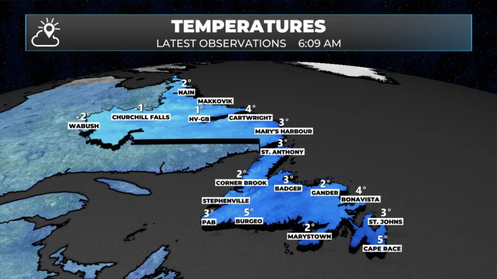
Temperature observations across NL from earlier this morning.

TODAY’S FORECAST
Weather-wise, today we are looking at numerous showers and flurries along the West Coast of the Island, while farther east, scattered showers will be the rule. Outside of the West Coast and Northern Peninsula, expect a mix of sun and cloud with high temperatures between 3º and 7º across the Island. Meanwhile, Labrador will see scattered flurries in the west today, with sunny breaks the closer one gets to the coast.
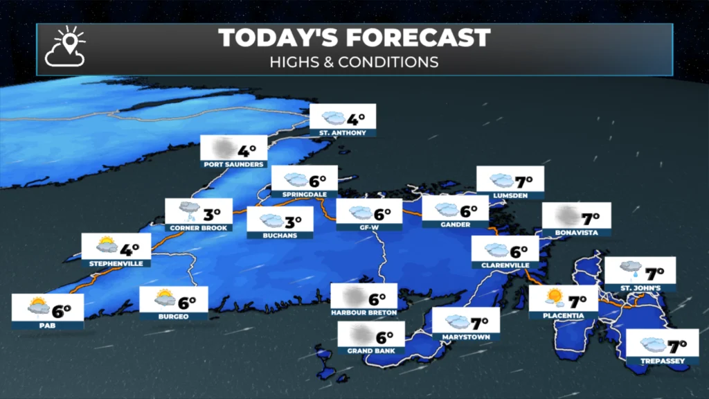
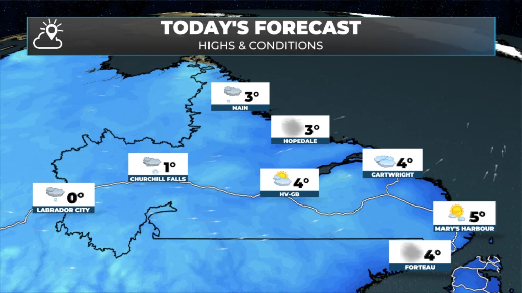
While it will not be overly windy across the region today, it will be breezy. Particularly in Labrador and along the Gulf of St. Lawrence. Expect westerly winds sustained at around 30 km/h, with gusts up to 70 km/h over exposed areas. Wind speeds will be somewhat less, but not much, farther east on the Island.

This morning’s update is sponsored by Roebothan, McKay, Marshall.
MakeTheCall.ca
PEAK AT THE LONG RANGE
Thursday and Friday look quiet across the region. The next low moves in Friday night and promises to spread more snow into much of the Big Land for the Friday night and Saturday period. Although it looks like more rain or a rain/wet snow. mix near the Straits and southeast coast. This will also be another rain producer for the Island between Friday night and Saturday, particularly in the south, central, and west, and into the GNP.
Another wave of low pressure will move through Saturday night, and Sunday will bring a secondary push of rain to eastern sections of the Island. Snow may be more intense along Labrador’s North Coast on Sunday.
There are some signals of a longer-range pattern change… but in the short term, it’s more of the same weather-wise. I’ll have a more detailed update later today!
I’ll have my next update posted over the weekend.
📱 Get the Sheerr Weather App in the Apple App Store and Google Play Store.
🗺️ Check out the Map Room to see all the latest weather observations for the Province.
🎥 Check out the Provincial Highway Cams to see 👀 what’s going on around our highways and byways!
Could we separate the morning briefing by region
A lot of reading to try and decipher what’s going to happen where. Not sure the morning brief is effective the way it is now, just trying to help
I can keep that in mind! Something you may find helpful is the regional forecasts already on the website.
If you’re on the mobile version, tap the two bars on the right. Then tap forecasts. That will give you the regions of the Province. Tap on the one you’re in and you’ll see a daily map and a 7-day forecast for that area.
Let me know if that helps!
Thank you Eddie the first time I seen the word grapple in a long time.
Thank you for your very detailed forecast. So easy to understand.
Thank you Eddie for all your updates. Have a great day
Thanks Eddie!
Thanks again Eddie…travelling up the GNP and through Labrador to Wabush starting Monday and will be watching your forecast closely!
Good morning Eddie, thanks for weather update.
How come I cannot get the photo contest on the apt??
Keep up the good work Eddie. I’m not on the Island right now but I still keep a watch on the weather. Have a good day
Thank you Eddie