
Wednesday Morning Weather Brief | August 6, 2025
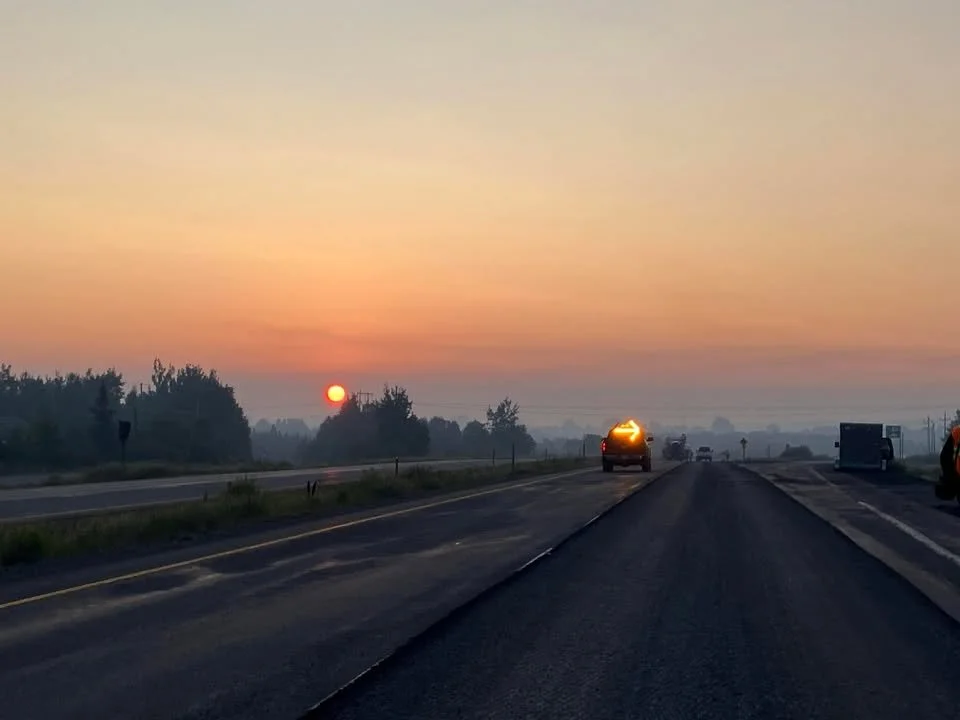
Grand Falls-Windsor this morning – August 6, 2025 — Smoke from the Martin Lake Fire obscuring the sunrise. Credit: Tiffany Ellis
Good Wednesday morning. Here is As of 5:41 AM NDT, here is the most up-to-date list of mandatory evacuations and evacuation alerts from the Government of Newfoundland and Labrador:
Mandatory Evacuations (leave immediately)
Small Point–Adam’s Cove–Blackhead–Broad Cove
Kingston
Western Bay
Sections of Holyrood (from the town boundary south to 377 Conception Bay Highway)
Parts of Conception Bay South (near Route 60 and 377 Conception Bay Highway)
Perry’s Cove
Cabin owners in the Martin Lake and Great Rattling Brook areas (off Route 360 in Central Newfoundland)
Evacuation Alerts (prepare to leave on short notice)
Salmon Cove
Ochre Pit Cove
This morning’s update is brought to you by Roebothan, McKay and Marshall

Visit MakeTheCall.ca for more
The Department of Fisheries, Forestry, and Agriculture, Newfoundland and Labrador, provided an update on the fire situation Tuesday evening (August 5, 2025) at 9:42 PM:
The Kingston wildfire remains very active as winds shifted throughout the day. Water bombers, a bird dog aircraft, helicopters, and ground crews actioned the fire, focusing efforts on the south towards Perry’s Cove. The fire is currently holding in the Spout Brook area. Easterly and then southerly winds are anticipated overnight which should slow any southern growth. Crews will monitor the southern perimeter through the night.
The wildfire in Holyrood is still active however efforts by water bombers to hold the perimeter were successful. Tomorrow ground crews are ready to start working the fire at the earliest opportunity.
Crews are also working a wildfire in Central, near the Martin Lake and Great Rattling Brook areas. A helicopter and ground crews actioned that fire throughout the evening. An Incident Management Team will be deployed to that fire tomorrow and suppression efforts will continue with a water bomber, three helicopters and ground crews. The fire is approximately 60 hectares. Road closures may be issued tomorrow.
In addition to the province’s four water bombers, a bird dog aircraft arrived yesterday from New Brunswick to assist with operations. Three Air Tractor 802’s were also requested from New Brunswick and are expected to arrive in the morning.
A province-wide fire ban is now in effect across Newfoundland and Labrador. Residents are reminded to stay alert and monitor official government channels for the latest updates and safety information.
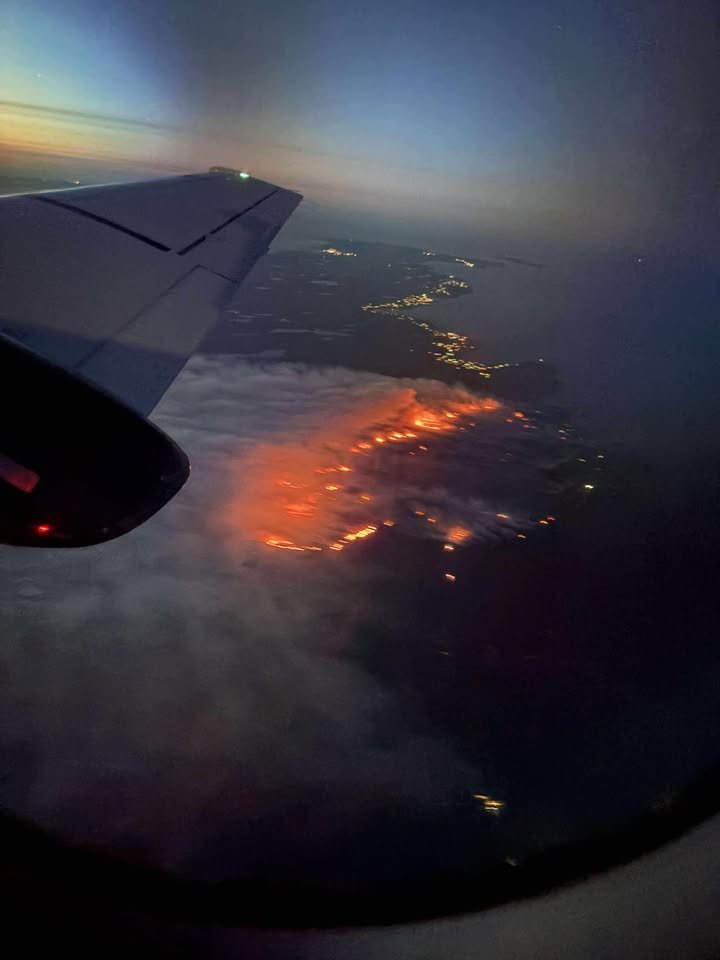
PROVINCE TO STREAM UPDATE ON FIRE SITUATION THIS MORNING AT 10:15 AM
The Government of Newfoundland and Labrador will be live-streaming an update on the fire situation at 10:15 AM. Premier Hogan will be joined by Honourable John Haggie, Minister of Justice and Public Safety, Honourable Lisa Dempster, Minister of Fisheries, Forestry and Agriculture, and departmental officials.
The availability will take place in the Media Centre in the Confederation Building at 10:15 a.m. It will be livestreamed on the Government of Newfoundland and Labrador’s YouTube channel.
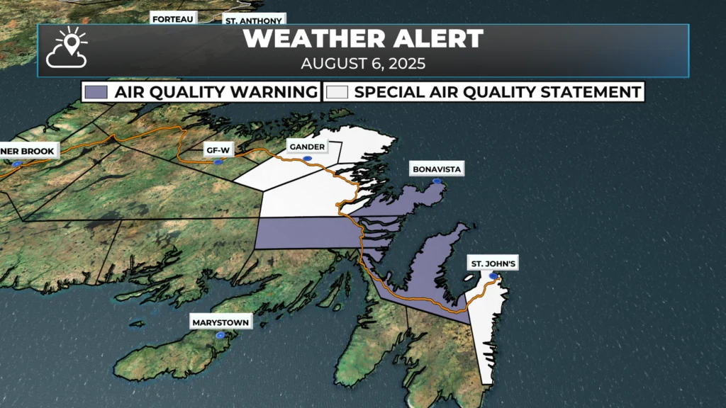
AIR QUALITY WARNINGS IN EFFECT THIS MORNING
Environment Canada, along with the Department of Environment and Climate Change and the Department of Health and Community Services of Newfoundland and Labrador, has issued multiple air quality warnings and special statements due to wildfire smoke.
Air Quality Warnings (Significantly Reduced Air Quality)
Regions affected:
Avalon Peninsula North
Bonavista Peninsula
Clarenville and vicinity
Details:
Smoke from wildfires over Conception Bay North and the Holyrood area is causing or expected to cause poor air quality and reduced visibility.
Conditions may change throughout the day as winds shift.
Wind forecast:
Avalon: Light and variable today, becoming southwest 20 km/h tonight.
Bonavista and Clarenville: Light southwesterly, with smoke expected to blow offshore later in the day.
Special Air Quality Statements (Moderate Risk)
Regions affected:
Bonavista North
Gander and vicinity
Terra Nova
St. John’s and vicinity
Details:
Smoke is reducing air quality across parts of northeast, eastern, and central Newfoundland, including the capital region.
Winds: Light southwesterly. Local smoke concentrations will vary depending on fire activity and wind conditions.
Health and Safety Guidance
Everyone is at risk during periods of heavy smoke, regardless of age or health status.
Common symptoms may include:
Eye, nose, and throat irritation
Headaches
Mild cough
More serious symptoms can include:
Wheezing
Chest pain
Severe coughing
Seek medical attention if symptoms are severe.
People more likely to be impacted by wildfire smoke include:
Adults aged 65 and older
Pregnant individuals
Infants and young children
People with chronic health conditions
Outdoor workers
Recommended precautions:
Limit time outdoors and avoid strenuous outdoor activities.
Keep doors and windows closed when indoors.
Use a good-quality air filter in your HVAC system or a certified portable air cleaner.
If outdoors, wear a properly fitted N95 or equivalent respirator mask.
Check in on vulnerable individuals in your care or nearby.
Follow guidance from local authorities at all times.
Additional Information
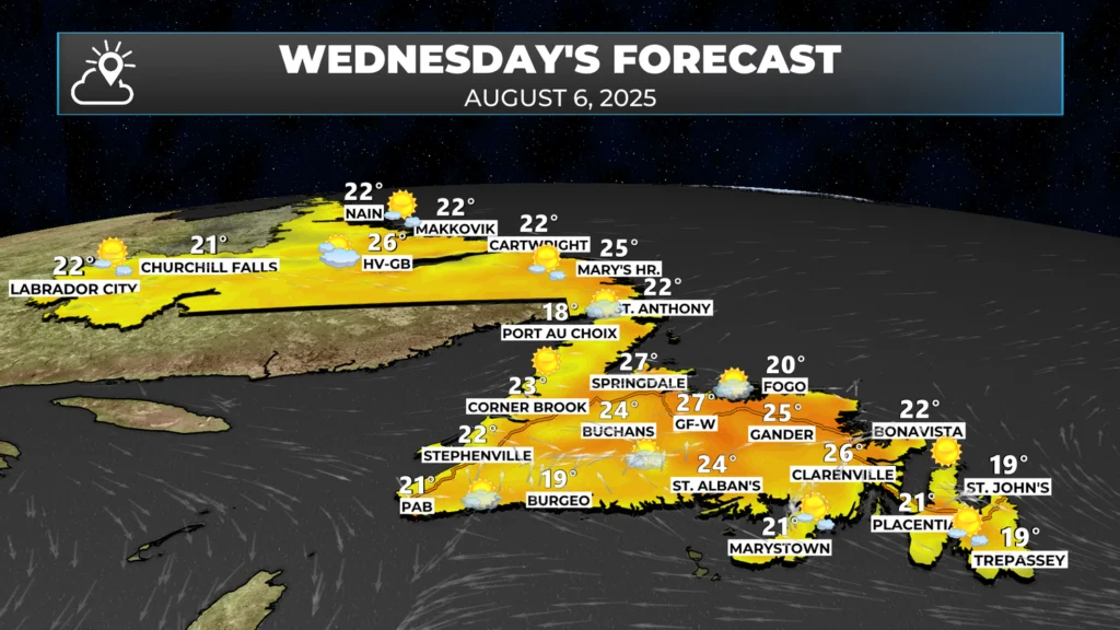
TODAY’S FORECAST
Another sunny, warm, and dry day is on tap for the Province. Highs will climb into the 20s for most areas, with wind speeds remaining light to moderate. We are in for a lovely stretch of weather over the next few days if you like summer. However, we are in for a very dry stretch… aside from forecasted pop-up showers and thunderstorms, there is currently very little meaningful precipitation in the forecast for the Province over the next 5 to 7 days.
TODAY’S WIND FORECAST
As mentioned in the air quality forecast (above), the wind direction is forecast to turn southerly and eventually westerly today for most of the Island. This will begin to push the smoke offshore and out of areas where air quality is currently extremely poor. However, the movement of the smoke may push it into new areas that are currently not experiencing any issues.
The wind speeds aren’t forecast to be high, with gusts of only 15 to 20 km/h expected, which is a good thing and should allow crews to continue to action the three fires ongoing on the Island as of this morning. The wind direction will be from the south and eventually shift to the west. That means the fires will likely have more growth on their northern and eastern sides than anywhere else. The hope is that the lack of wind will prohibit extreme fire behavior this afternoon.
I’ll post whatever new information becomes available throughout the day. I’ll also stream the Government’s live stream to my Facebook and YouTube pages in order to ensure as many people as possible have access to it.
—> Be sure to get the Sheerr Weather App for my latest updates delivered to your device!
Thank you Eddie 😊
Thanks Eddie for the updates
Thanks for the updates, Eddie. A very comprehensive report of what’s happening with the forest fires, plus a beautiful forecast, if I might add, as it probably isn’t much help to taming the fires. Nonetheless, great job, Eddie, everything I need to know is Ll here in your app! Have a great day!
Thanks Eddie for the updates..
Thanks Eddie!!!
Thanks for the detailed update.
Here in Harbour Grace everyone is on edge. Going over the hill into Carbonear yesterday the hill going into Victoria was half obscured by the smoke from the fires. A friend of mine in Salmon Cove was packing up to be ready to leave, I offered her our spare room if she was told to evacuate. Hopefully the fires will get held or reduced soon, everyone is losing sleep and on edge if they will be next to evacuate. Thanks for all the updates Eddie, they help settle some nerves.
Thank you Eddie for keeping us informed. Praying everyone stays safe. And a huge thank you to other Provinces who are helping with the devastating fires in our beautiful province
Slight correction there that the evacuation in CBS is not route 60 to 377, that’s in Holyrood only. The numbers on “conception bay highway” repeat once you pass the Holyrood bridge.
Thanks for the amazing updates . I check the app often during the day as the updates come available. My phone lets me know when updates are available. Your app is more reliable for up to date news than any broadcasting company. Especially the wildfires ., felt like I didn’t know what was happening before your app . Appreciate your work Eddie . Have a great day ☀️Meanwhile it Sunny sky’s in St Brendan’s
Thanks for the updates Eddie. I live in Carbonear North and it’s unnerving to know the Kingston fire has moved closer. Though worried myself, my heart aches for all evacuees who are facing an uncertain future. Your coverage is thorough and so aporeciated at this trialsome time. Again thanks.
Thank you Eddie, I can always count on you during the day for updated info, everyone’s nerves are on edge and you are helping to ease them a bit with your wonderful app! Praying these fires will be contained soon and for everyone who had to be evacuated! 🙏🏻🙏🏻🙏🏻🙏🏻
Thank you for keeping us informed about the wildfires that are burning in our beautiful Province. You are a phenomenal meteorologist who always goes above and beyond.
Thanks Eddie…feel more informed & safe with your app keeping us up to date.
Thank you Eddie for keeping us updated. Well informed is well prepared!
Thanks for news on wildfires
Anyway you can get a fire and smoke map somewhere. Your app is really really helpful !!