
Wednesday Morning Update — February 4, 2026

Forecasts, alerts & live weather for Newfoundland and Labrador
Here are today’s weather highlights:
For the first time in a long time, the weather across Newfoundland and Labrador will be quiet across the board as a brief ridge of high pressure moves overhead.
Expect partly to mostly sunny skies today.
Highs reach near 0ºC over much of the island and the minus single digits to teens in Labrador.
Some light snow returns to southern areas of the Avalon Peninsula tomorrow, and more widespread flurries and/or light snow will fall tomorrow night into Friday.
A potent low will pass close enough to Newfoundland over the weekend that I’m paying attention to it, but most computer guidance keeps it far enough offshore that it shouldn’t impact our weather. That could change, which is why I’m mentioning it.
It certainly is a bit chilly out there this morning, with all areas well below freezing, but Badger and Deer Lake are at -24ºC and -18ºC, respectively. Those appear to be the coldest spots on the Island. Most other locations are in the single digits to teens below to begin the day.
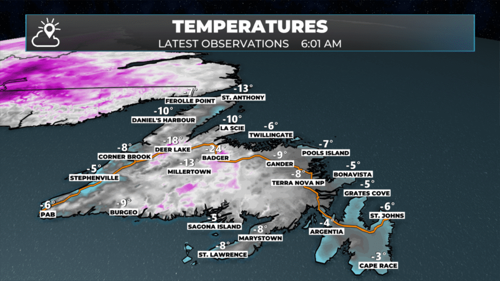
Temperatures as of 6:01 AM this morning – February 4, 2026.
As cold as it is now, temperatures will rebound nicely today and climb into the single digits below freezing across much of the Island. Some areas in the south and on the Burin Peninsula may reach the freezing mark for a high this afternoon.
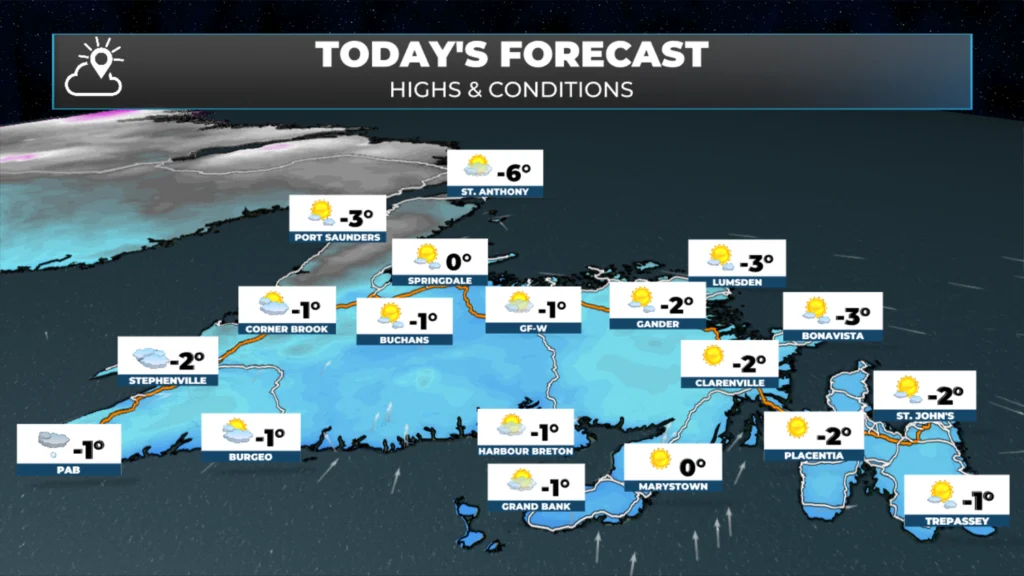
Newfoundland’s forecast for today — February 4, 2026
Meanwhile, it’s not as cold in Labrador as it’s been in the recent past, but it’s still a cool morning out there. Temperatures along the coast are into the minus teens, while the west is into the -20s. Churchill Falls looks to be the cold spot, at -25ºC this morning.
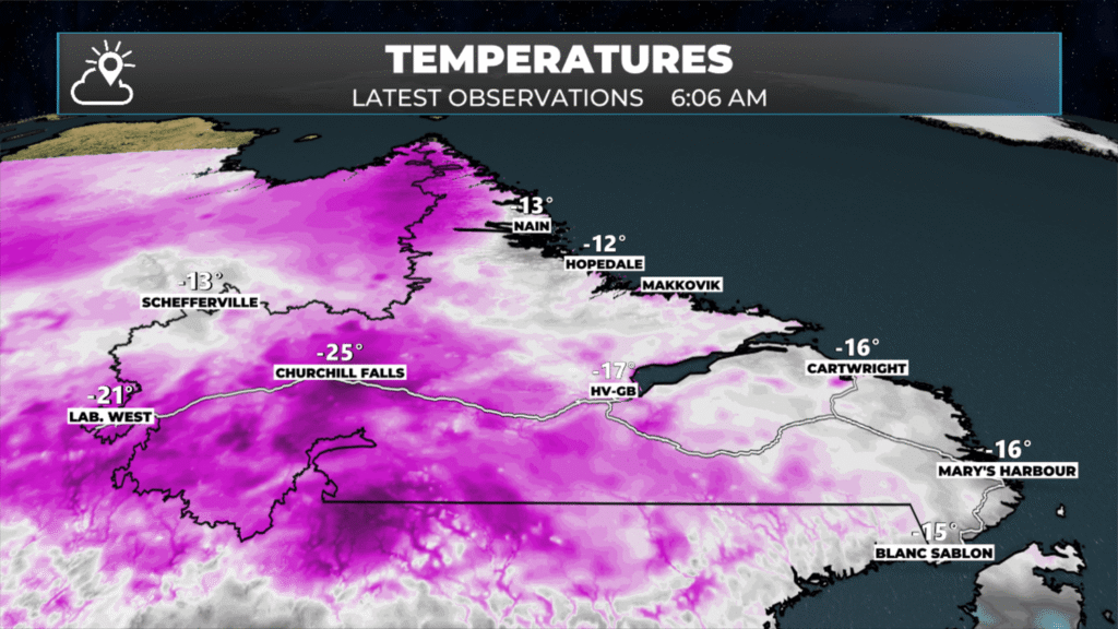
Temperatures as of 6:06 AM NST (5:36 AM AST) this morning – February 4, 2026.
Temperatures in Labrador will also rebound nicely today, reaching the minus teens for highs under an abundance of sunshine. This will be the nicest day many of us had, province-wide, in a while!
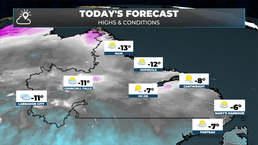
Labrador’s forecast for today — February 4, 2026
Thursday’s Outlook
A weak area of low pressure will pass southeast of the Avalon Peninsula. At this time, it looks like it may be too far south to bring any snow to southern and southeast Newfoundland, which is a bit of an update from last evening. Behind that low, a couple of disturbances will move through, which will bring some scattered pockets of light snow and flurries to much of the Island Thursday night and Friday. However, even with that, widespread significant snowfall is not expected through the end of the workweek… and likely the weekend.
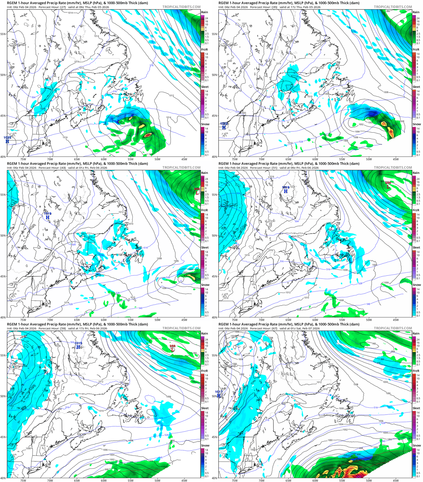
A loop of of the RDPS model showing how the weather plays out between Thursday and Friday (Feb 5 – 6, 2026)
I’ll have updates for you throughout the day!
📱 Get the Sheerr Weather App in the Apple App Store and Google Play Store.
🗺️ Check out the Map Room to see all the latest weather observations for the Province.
🎥 Check out the Provincial Highway Cams to see 👀 what’s going on around our highways and
By using this website, you agree to our use of cookies. We use cookies to provide you with a great experience and to help our website run effectively. Privacy Policy
Thanks Eddie
Good morning Eddie thanks for keeping us updated enjoy your day
Looking good in gander Tks
Nice and calm in Pouch Cove this morning with no wind, thanks for the update
Good Morning Eddie. A beautiful day. I guess it’s too cold for the sun to melt ice build-up on driveways without using salt. My driveway is like a skating rink!!
Great job you are doing Eddie! Very well explain comprehensive reporting! I’m sure there are always those who think they can do a better job. For them, ignorance is bliss!