
Tuesday Morning’s Weather Briefing — May 18, 2026
This morning’s update is sponsored by Roebothan, McKay, Marshall.

Visit MakeTheCall.ca today to learn more about how the law firm can help you!
Good Tuesday morning!
Here are today’s highlights:
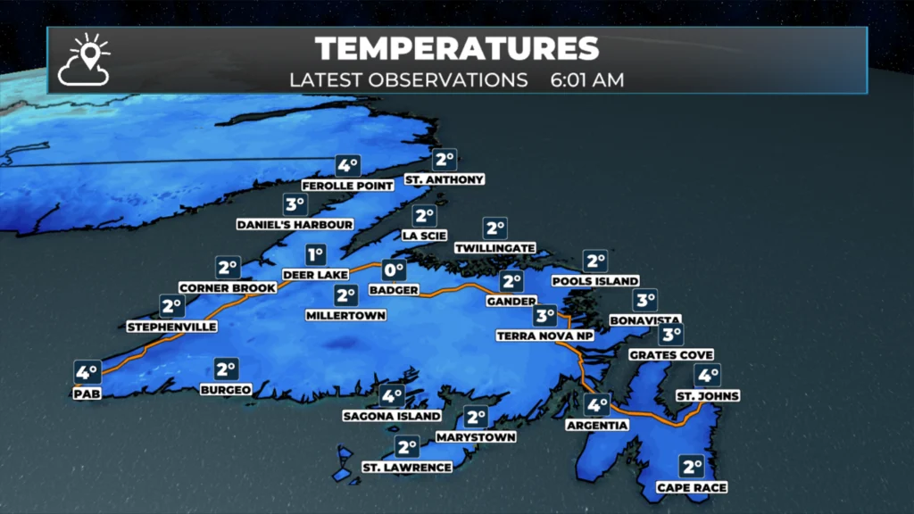
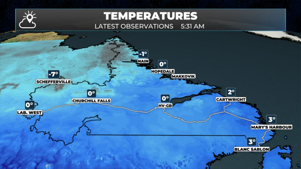
Temperatures are in the lower single digits to near freezing across Newfoundland and Labrador this morning.
Wind speeds are generally light to moderate, so it doesn’t get that much cooler than the actual air temperature in most spots.
Did you know the Canadian wind chill formula does not calculate wind chills if the air temperature is above 0ºC?
Temperatures peak at 9º to 15º across Newfoundland today (cooler in onshore winds) and 3º to 12º in Labrador. It will be coolest along the coast and warmest inland and west.
Generally decreasing cloud today over most of the Province. In Labrador West, clouds decrease this morning and then increase this afternoon.
There will be a few sprinkles near the southwest coast this afternoon.
Areas of fog will be found along and near east-facing shores today.
RIGHT NOW
Temperatures in the lower single digits to near freezing were recorded across Newfoundland and Labrador this morning, with Terra Nova National Park reporting 4.3°C at 11:30 PM NDT Monday. The hot spot in the province reached 14.4°C at Terra Nova National Park, while the cold spot dropped to 2.4°C at Saglek.
Wind speeds remain generally light to moderate, with Terra Nova National Park recording northwest winds at just 7 km/h, while Stephenville saw winds of 20 km/h gusting to 40. With these conditions, the actual air temperature and what it feels like remain quite similar across most locations.
Did you know? The Canadian wind chill formula only calculates wind chill values when temperatures are zero or below and wind speeds are 5 km/h or higher. Since temperatures are hovering around or above freezing today, no official wind chill values are being reported in most areas.
Today’s Forecast
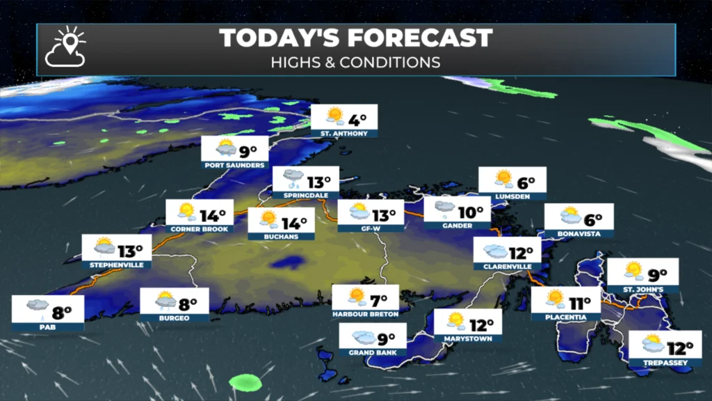
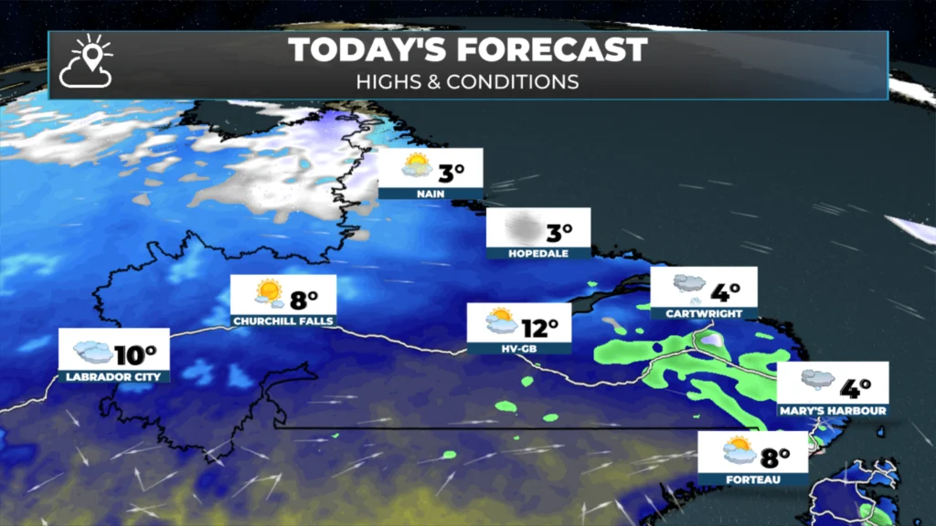
Temperatures will peak around 9º to 15º across the Island, with locally warmer (inland) and cooler (coastal areas) temperatures found. The warmest readings will occur inland and along the west coast, while areas with onshore winds – particularly along the east coast – will remain noticeably cooler. The warmest readings today will be found in the western and southwest parts of the Island. Labrador temperatures will range from the low single digits along the coast to highs near 10º in the west.
Generally, decreasing clouds are expected over most of the province today. Stephenville’s forecast calls for increasing cloudiness overnight after a few clouds this evening, while in Labrador West, clouds will decrease this morning before increasing again this afternoon.
Areas of fog will be found along and near east-facing shores today in the light onshore wind. There may also be a few sprinkles over southwestern Newfoundland this afternoon.
Snow in Labrador on Wednesday and Thursday?
An area of low pressure will move from west to east across Labrador between tomorrow and Thursday, and the air will be cold enough north and west of the track for a late-season snowfall. Initially, snow will develop in Labrador West early Wednesday before overspreading more of the big land. If you can imagine a line from Lab West to Rigolet, areas along and north of this line will see snow, while areas south will see mostly rain. This low moving into Labrador will also bring another round of rain to the Island Wednesday… along with some gusty westerlies.
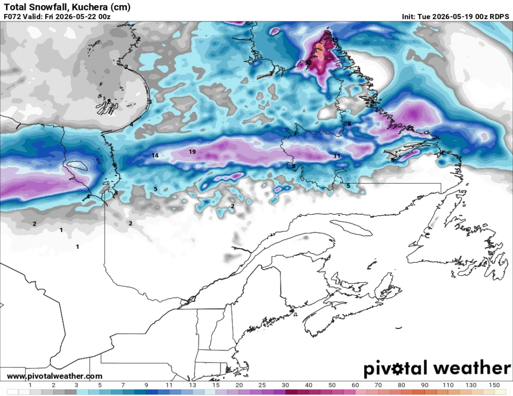
Expected snowfall between early Wednesday and Thursday evening (9:30 PM NDT – 9 PM ADT)
More details on this later today!
📱 Get the Sheerr Weather App in the Apple App Store and Google Play Store.
🗺️ Check out the Map Room to see all the latest weather observations for the Province.
🎥 Check out the Provincial Highway Cams to see 👀 what’s going on around our highways and
Thanks Eddie. I didn’t know about the windchill. Good to know.
Good morning Eddie thank you have a great day
Good morning and have a great day Eddie
Thank you Eddie. Interesting facts about windchill… I had no idea how that was measured 👍
Good Morning Eddie! Thanks for update
Good Morning Eddie.Thank You For The Update.You Have A Great Day.
Good morning Eddie!Thanks for the update….
Thanks for the update Eddie, have a great day
Thanks so much Eddie for your daily updates. I really appreciate you