
Tuesday Morning’s Weather Briefing — May 12, 2026
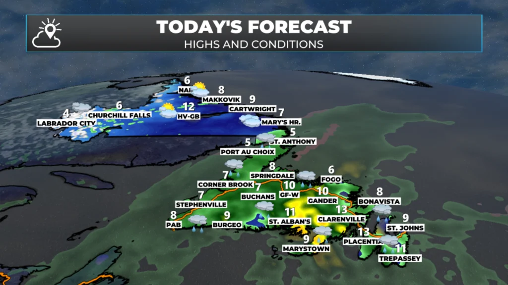
NL’s expected highs and conditions for today. May 12, 2026.
This morning’s update is sponsored by Roebothan, McKay, Marshall.

Visit MakeTheCall.ca today to learn more about how the law firm can help you!
Good Tuesday morning!
Here are today’s highlights:
Areas of heavy rain are already being found over much of the Island in numerous showers and pockets of rain.
Rain coverage will increase today across Newfoundland and southeast Labrador as an area of low pressure intensifies over the region.
Rainfall of 25 to 50 mm will be common, with more than 60 mm possible in parts of the South Coast, Connaigre, and the Burin Peninsula.
A Rainfall Warning is in effect for Connaigre and Burin Peninsula until Wednesday morning for 40 to 60+ mm of rain.
The rain ends by tomorrow morning for most areas, except along the West Coast, Northern Peninsula and southeast Labrador, where the rain will mix with or change to wet snow on Wednesday before ending.
Significant snowfall is possible in the highest peaks of western Newfoundland and through a large area of southeast Labrador.
This will impact your travel in southeast Labrador tomorrow.
Special Weather Statements are in effect for western Newfoundland and southeast Labrador.
This Morning & Today
The rain has arrived and will continue to spread across Newfoundland and southeast Labrador throughout the day. At the moment, the heaviest rain is over the southern and interior parts of Newfoundland, with scattered showers elsewhere. That said, radar indicates an area of heavy rain isn’t far from reaching the southwest Avalon. The radar loop (below) shows this well.
A Rainfall Warning is in effect for the Burin Peninsula and Connaigur Island until Wednesday morning. This area will see upwards of 60 mm of rain, with locally higher amounts possible. That said, much of the Island and southeast Labrador will see a solid 25 to 50 mm of rain by tomorrow morning. It’s going to be widespread soaking rain.
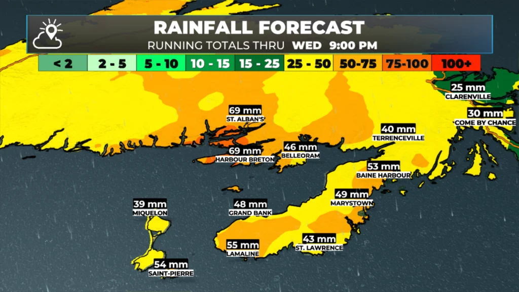
Expected rainfall between today and late Wednesday. May 12 and 13, 2026.
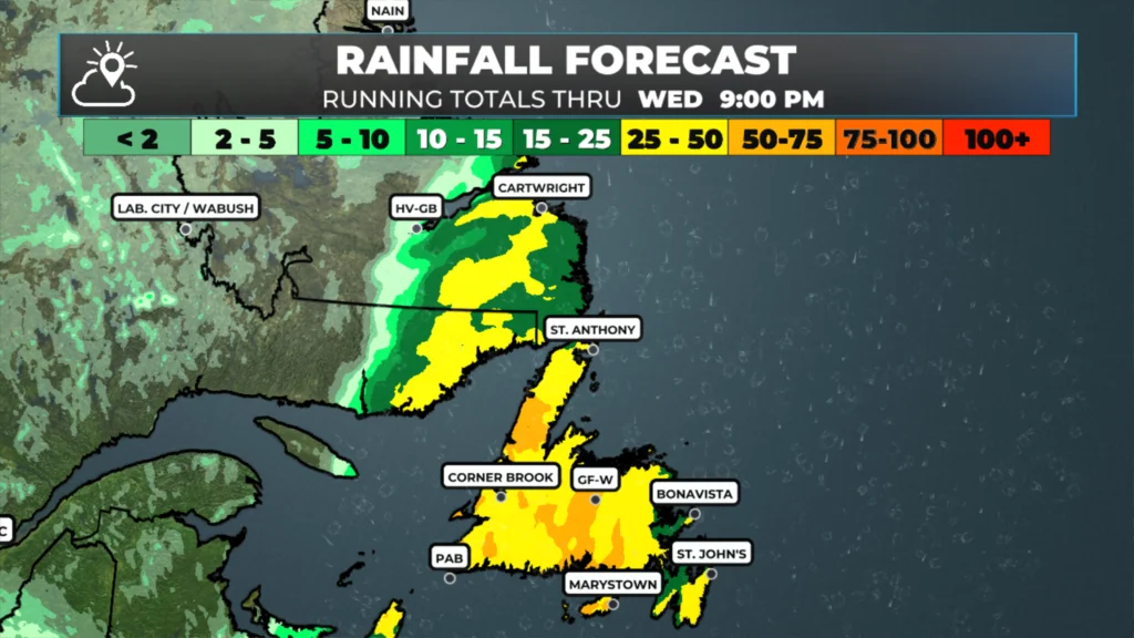
Expected rainfall between today and late Wednesday. May 12 and 13, 2026.
Futurecast times this out for you and should indicate when the heaviest rainfall will be in your area. Note that the Sheerr Weather App can do this as well. Simply check the hourly forecast panel and the 7-Day panel to find out when and how much rain is expected in your area.
Wednesday into Wednesday Night
The rain in most areas will end late tonight or early Wednesday morning. However, that will not be the last of this low-pressure centre’s fun and games with us. As the low moves over the Island and into the North Atlantic, it will slow down and pull in some colder air. This will also cause the rain to change to snow over western Newfoundland and southeast Labrador, and the snow will fly from later tonight through Wednesday afternoon or evening before ending. Special Weather Statements are in effect for western Newfoundland and southeast Labrador.
While I expect only about 5 cm of wet snow along western Newfoundland’s coast (including the Northern Peninsula), there may be as much as 20 cm inland and over higher terrain. It will be a different story in southeast Labrador, where significant snowfall is possible over a wider area and may total as much as 30 cm by the time it wraps up late Wednesday. While snow is not uncommon in May in Newfoundland and Labrador, many may not expect winter storm conditions when travelling. This will be the case in southeast Labrador tomorrow, and subsequently, you may want to rethink travel into and through that area.
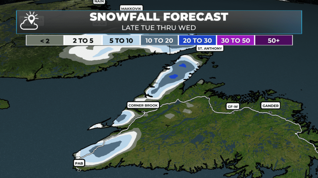
Expected snowfall from tonight through Wednesday (May 13, 2026).
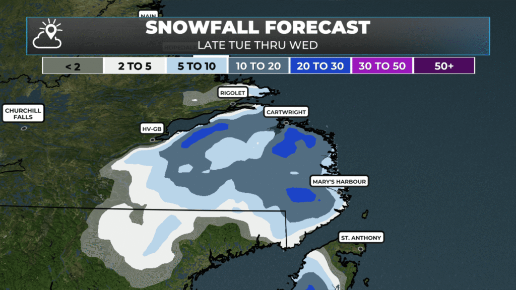
Expected snowfall from tonight through Wednesday (May 13, 2026).
My next update will be later today. Stay tuned for details!
📱 Get the Sheerr Weather App in the Apple App Store and Google Play Store.
🗺️ Check out the Map Room to see all the latest weather observations for the Province.
🎥 Check out the Provincial Highway Cams to see 👀 what’s going on around our highways and
Thank You. Will that’s a wet forecast for today and tomorrow. I’m in Cow Head.
Good morning Eddie and thanks for the update , have a wonderful day
I have relatives traveling on Wednesday from Lanse Au Loop area to Corner Brook. It doesn’t sound good. 😢
Good morning Eddie, thanks for the update. Have a great day and stay dry.
Love the app Eddie. I’m in Burnt Berry,just on the outskirts of Springdale
Good morning love this forecasting to plan my day
The radar view in your app is moving too fast. Need to be able to slow it down.