
Tuesday Morning’s Weather Briefing — March 3, 2026
This video shows what we can expect across NL for today — March 2, 2026
Good Tuesday Morning!
Here are today’s weather highlights:
Snow Squall Warnings (Yellow Level) are in effect for parts of western Newfoundland this morning, while a Snow Squall Watch (Yellow Level) remains in effect for the Burin Peninsula and the southern half of the Avalon Peninsula.
Temperatures are bitterly cold to start the day, with readings in the minus teens and 20s across NL, with even colder wind chills.
Outside of scattered flurries, the weather across the Province will be fairly quiet today, and eventually, not as cold as yesterday.
The next round of winter weather arrives tomorrow, and this will be another round of snow for much of the Island (5 to 15 cm), which may end as or change to rain before ending over parts of eastern and southeastern Newfoundland.
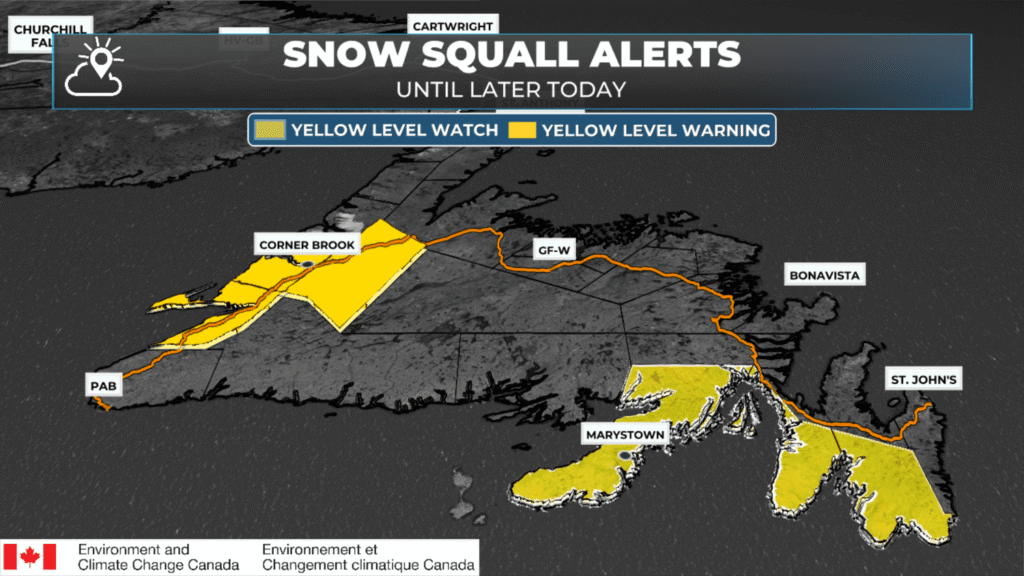
Current Snow Squall Alerts for Newfoundland as of 6:30 AM on March 3, 2026.
The Forecast
Across the Province today, we can expect a widespread mix of sun and cloud, along with high temperatures well below freezing, but for many areas it will be several degrees warmer than yesterday. However, wind gusts as high as 60 km/h in some areas will keep wind chills in the minus teens and twenties. There will be areas of scattered flurries and snow squalls over western and southern Newfoundland this morning, which will become less numerous this afternoon. As of about 6:30 AM NST, Yellow Level Snow Squall Warnings are in effect for western Newfoundland, and Watches are in effect for the Burin and southern Avalon Peninsulas.
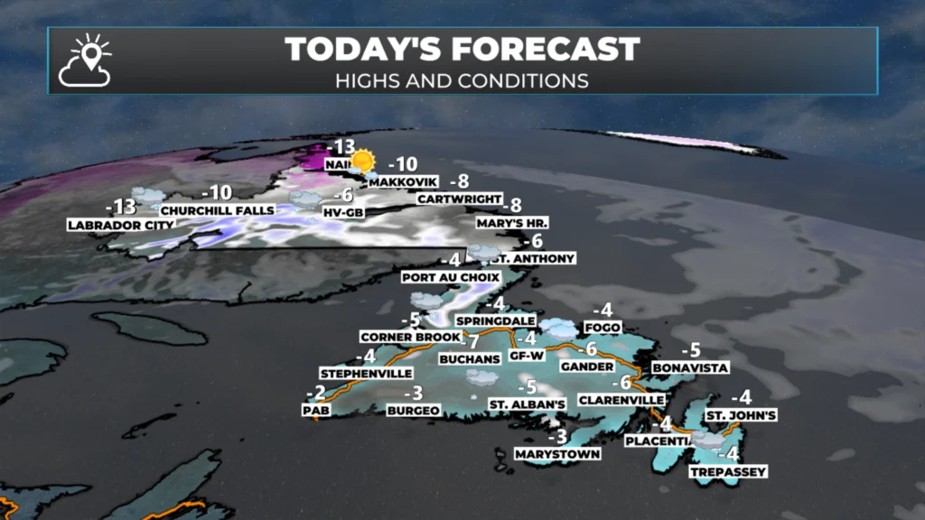
NL’s forecast for today – March 3, 2026
The road report suggests that various highways and byways are snow-covered or partly snow-covered this morning. The highway cameras across the Province’s road network confirm the presence of snow in some areas. You may want to allow some extra travel time this morning if you’re in an area seeing snow.
Speaking of snow, the next weather-maker to bring more widespread white stuff to the Island will arrive tomorrow. This is a fast-moving low that will race across Newfoundland during the day. Snow will arrive in the morning and end in the evening (or before) for most areas, the exception will be along the West Coast, where onshore flurries and snow squalls will set up shop later Wednesday and Thursday as another round of arctic air moves in.
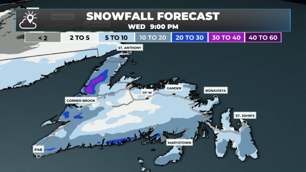
The snowfall forecast from Wednesday morning through Wednesday evening – March 4, 2026.
Snowfall amounts will not be significant in most areas, with a widespread 5 to 15 cm expected. As it looks now, the higher end of that range will be in the east, where the most intense snowfall rates will occur during the. midday on Wednesday. It looks very similar to last week’s system, where it snowed heavily for an hour or two and then stopped. Tomorrow’s hourly snowfall forecast for the Metro (as an example) shows this well.
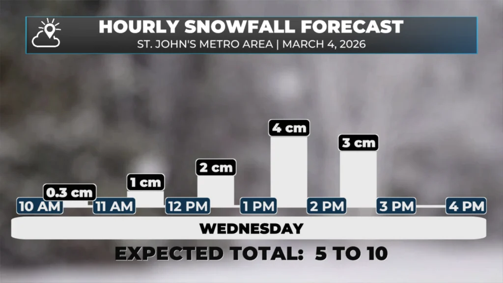
The hourly snowfall forecast for the St. John’s Metro area for tomorrow (March 4, 2026).
Once past tomorrow, arctic air returns for Thursday and another bitterly cold day is in the offing for much of NL. And beyond that we do appear to be in for a few days of quiet weather… for now.
I’ll have updates for you throughout the day!
📱 Get the Sheerr Weather App in the Apple App Store and Google Play Store.
🗺️ Check out the Map Room to see all the latest weather observations for the Province.
🎥 Check out the Provincial Highway Cams to see 👀 what’s going on around our highways and
Good morning Eddie, thanks for weather update.
Good Morning Eddie! Winter is not going anywhere yet it seems. Thanks for keeping us updated.
Thanks Eddie
Thanks Eddie
Thanks Eddie for the update….
Thanks, Eddie.
Morning Eddie thanks for the update, have a wonderful day