
Tuesday Morning’s Weather Briefing — March 24, 2026
Good Tuesday morning!
Here are today’s weather highlights:
A potent winter storm will bring heavy snow, ice pellets, freezing rain and rain to various areas of Newfoundland today. Winter-related weather alerts are in effect from Environment Canada, ranging from Orange Level Winter Storm Warnings to Yellow Level Blowing Snow Advisories and Wind Warnings.
Snow will be heavy at times on the Avalon and Burin Peninsula through early morning, then change to rain by noon (or earlier), with ice pellets and freezing rain.
Areas to the west will see snow fly throughout the day and into tonight, before ending
Snowfall totals for much of the Island will be near or over 30 cm.
High wind speeds will be found today over southern areas of the Island this evening and tonight for central and northwestern areas. Gusts near 100 km/h are likely for many areas from Twillingate to the Avalon Peninsula North.
Don’t forget you can use the Radar+ feature in the app to track the snow, ice and rain and is moves in and through.
Today’s Outlook
Snow on the Avalon and Burin Peninsulas this morning will change to rain or drizzle through a period of ice pellets and freezing rain. Temperatures will rise above freezing for a few hours before colder air returns this evening. This will occur earlier the farther south one goes and later the farther north. For instance, the Metro area will not see the change until after 9 AM. Ahead of this change, the snow will fall quite heavily, and rates may be as high as 4 to 6 cm an hour in some areas this morning.
The rain and freezing rain will last for a few hours but should be mostly done by mid-afternoon. Areas to the west will see the snow fly this morning, and for the most part, that will continue into this evening or tonight before ending. The Burin Peninsula will see a break, and may see another round of snow this afternoon or evening as the low departs.
The animation below of future radar and satellite imagery should paint a fairly clear picture of the region today.
Snowfall today will be significant. In the east, most of the snow will have fallen by noon, with very little after that. Central, interior, northeastern and even parts of western Newfoundland will see the snow continue into tonight before ending. I’m still expecting a widespread 30 to 50 cm of snow by the time we are said and done with this one. The highest amounts may end up over northeastern Newfoundland.
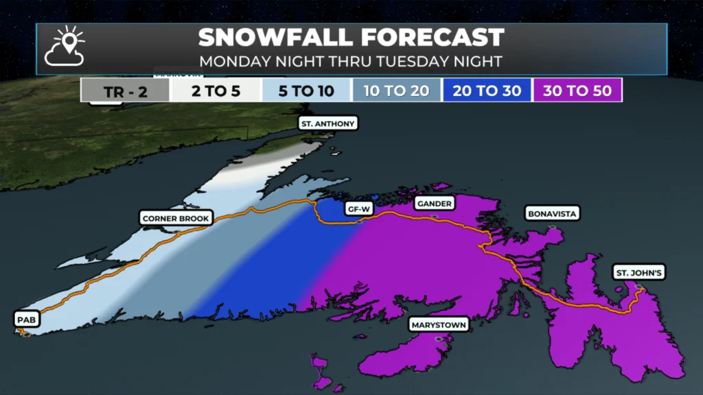
Expected snowfall from late last night through early Wednesday (March 25, 2026)
Wind today will also be high over southern areas in the morning and then shifting to central and northeastern areas later today and tonight. This will be due to the low arriving, corssing and departin Newfoundland through the day. As the low departs, it will generate an area of high winds on the western side, primarily affecting central and northeastern areas, with a few hours of gusts near 100 km/h from the northwest this evening into tonight. The animation below shows this well.
Meanwhile, the weather in Labrador today will be quite, sunny and seasonable. Highs will be in the minsu single digits to minus teens with no significant weather on the go. That’s a forecast I can get behind!
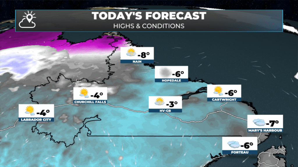
Labrador’s forecast for today – March 24, 2026
I’ll have updates throughout the day on my socials and will have a live stream starting before 7 AM!
📱 Get the Sheerr Weather App in the Apple App Store and Google Play Store.
🗺️ Check out the Map Room to see all the latest weather observations for the Province.
🎥 Check out the Provincial Highway Cams to see 👀 what’s going on around our highways and
Do you have a shovel alert time for metro ?
Thanks Eddie
Good Morning Eddie. Thanks for keeping us updated! Hoping this one will be the last one for the season ……. Maybe that’s just wishful thinking on my part!
Thanks Eddie for the update have a great day
Thanks Eddie for weather update
This is the last storm I’m thinking. I can handle anything except ice. That’s the only thing keeps me housebound. Thanks for all your hard work Eddie
Thanks Eddie for keeping us informed. It’s a good thing we only got 20 cm of snow because the streets in Metro is atrocious. Not just the side streets but the main streets, quesss their waiting for the rain to wash it away.