
Tuesday Morning’s Weather Briefing — June 2, 2026
Good Tuesday Morning! Improvement is in today’s forecast!
This morning’s update is sponsored by Roebothan, McKay, Marshall.

Visit MakeTheCall.ca today to learn more about how the law firm can help you!
Here are today’s highlights:
The weather improves today across central and eastern Newfoundland.
Highs reach the single digits and teens across the Province under a mix of sun and cloud.
A few isolated showers will be found later today on the Northern Peninsula.
Warmer weather returns for the middle part and end of the week on the Island, while a cold front sneaks into Labrador.
Central and eastern parts of the Island are shaking off a messy Monday night. Rain and flurries rolled through overnight, and the cold northwest flow chasing them in has us sitting right around the freezing mark this morning — colder than that once you factor in the wind chill, with gusts still high enough to make you reach for the heavier coat. The West Coast is the outlier, a few degrees milder under mostly clear skies. Temperatures in the Big Land are also in the single digits above freezing this morning.
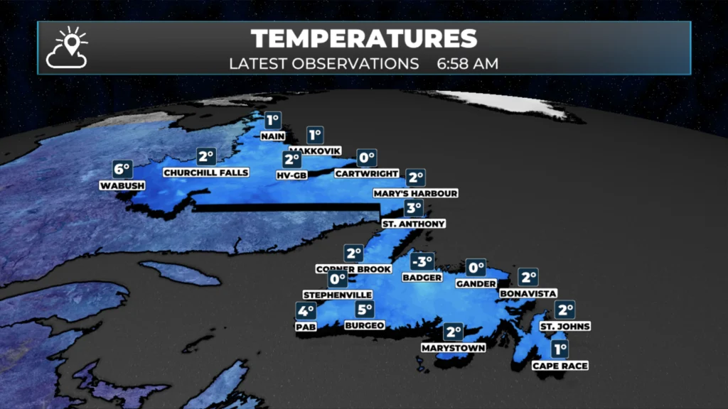
NL Temperatures as of just before 7 AM on June 2, 2026
Today improves for central and eastern areas of the Island, but it will take time. The northwest flow slowly chips away at the cloud through the morning, and by mid-to-late afternoon most of us should see some sunshine finally break through. That may happen a bit earlier in spots as there is already a good deal of clear breaks apparent in the satellite imagery, confirmed by my eyes and webcams!
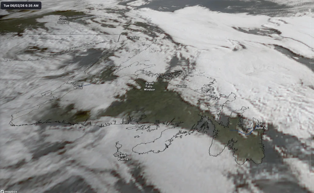
Satellite image of Newfoundland taken at 6:35 AM this morning | June 2, 2026
Highs creep into the single digits to low teens depending on where you are, though those gusty northwest winds keep it feeling cooler than the number suggests. The Big Land is the warm spot today — but it pays for it with showers likely through the afternoon and evening, so it’s not exactly a free pass. There may be a few isolated showers this afternoon on the Northern Peninsula and the West Coast.
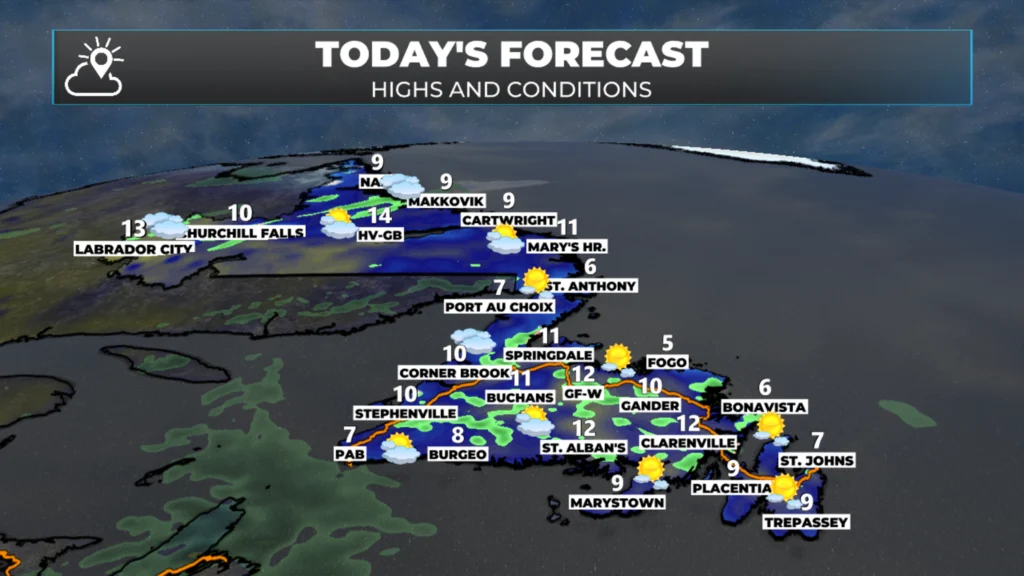
NL’s forecast for today – June 2, 2026
The real story this week is what comes next. A ridge of high pressure builds in from the west Wednesday and Thursday and flips the script entirely, with a genuine warm-up settling over just about the whole province. We go from this morning’s wind-chilled chill to afternoons well into the teens, with a few spots flirting with 20°C — proper early-summer warmth, especially out west and over in Labrador, where the swing is the most dramatic of all. Wednesday and Thursday are the days to make the most of it, no question.
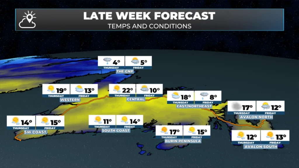
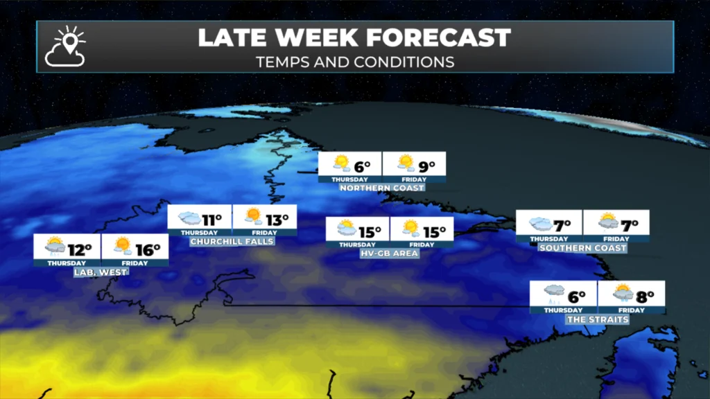
The window doesn’t stay open long. A system tracks in from the west by Thursday night and Friday, bringing rain to the northern and central parts of the Island first, then spreading toward the Labrador coast. The Northern Peninsula looks to take the brunt of it. The Avalon should hang on to the dry weather a little longer, but clouds and cooler air filter back by the weekend as the whole pattern resets — and by Saturday we’re back in the single digits where we started.
My next update will be posted later today!
📱 Get the Sheerr Weather App in the Apple App Store and Google Play Store.
🗺️ Check out the Map Room to see all the latest weather observations for the Province.
🎥 Check out the Provincial Highway Cams to see 👀 what’s going on around our highways and
Thanks Eddie!
Good morning Eddie thanks for updating us, have a wonderful day