
Tuesday Morning’s Weather Briefing — June 16, 2026
Good Tuesday morning! Here are today’s highlights:
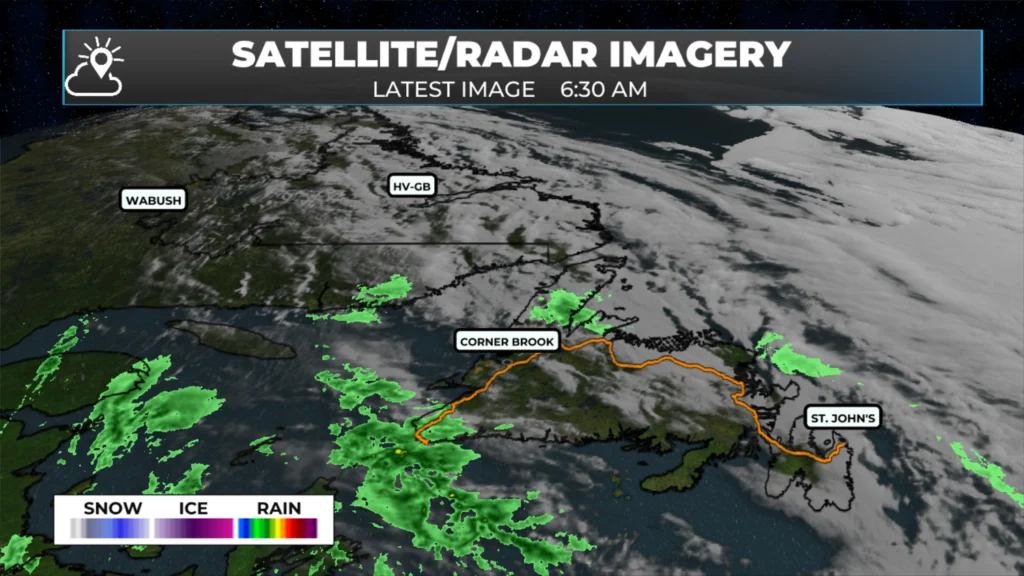
🌧️ Rain is already impacting Labrador and western Newfoundland this morning and will gradually spread eastward through the day and tonight.
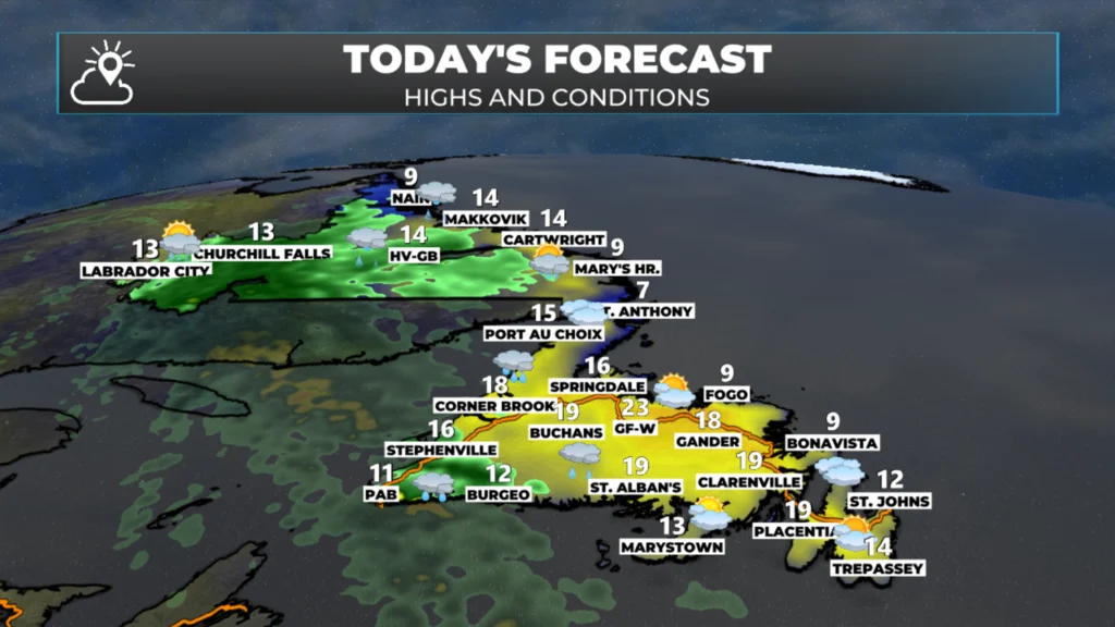
🌡️ Central Newfoundland will be the warm spot today, with inland highs reaching 18 to 21°C, while eastern and coastal areas stay much cooler under fog and onshore winds.
💨 Strong easterly winds will affect the Southwest Coast, with gusts near 60 km/h possible around Channel-Port aux Basques and the Wreckhouse area.
🌧️☁️ Rain spreads into Central Newfoundland this evening and reaches eastern Newfoundland and the Avalon overnight, setting the stage for a wet and cooler Wednesday.
This morning’s update is sponsored by Roebothan, McKay, Marshall.

Visit MakeTheCall.ca today to learn more about how the law firm can help you!
A low-pressure system that dumped 40 to 60 mm of rain across Quebec’s Eastern Townships yesterday is now tracking northeast through Labrador. As it does, it’s dragging a front across Newfoundland and Labrador over the next 36 hours.
Today, the focus is on Labrador and western Newfoundland. Rain is already falling across central Labrador and parts of the West Coast, while eastern Newfoundland remains largely dry under cloudy skies and areas of fog.
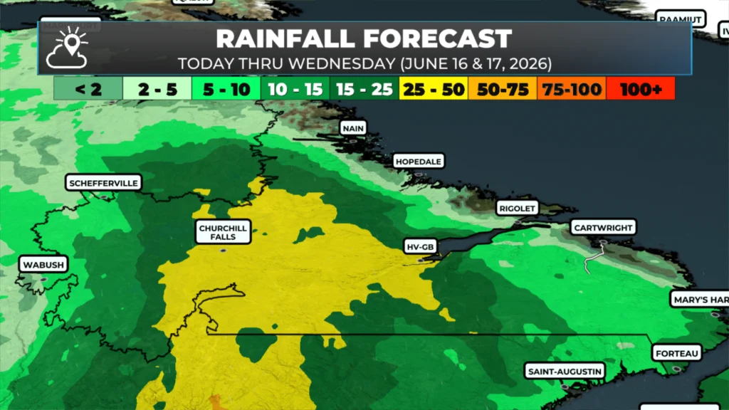
The heaviest rainfall today will be across central Labrador, including Happy Valley-Goose Bay, where more than 25 mm could fall before midnight. Another 10 to 15 mm is possible on Wednesday before the rain finally tapers off.
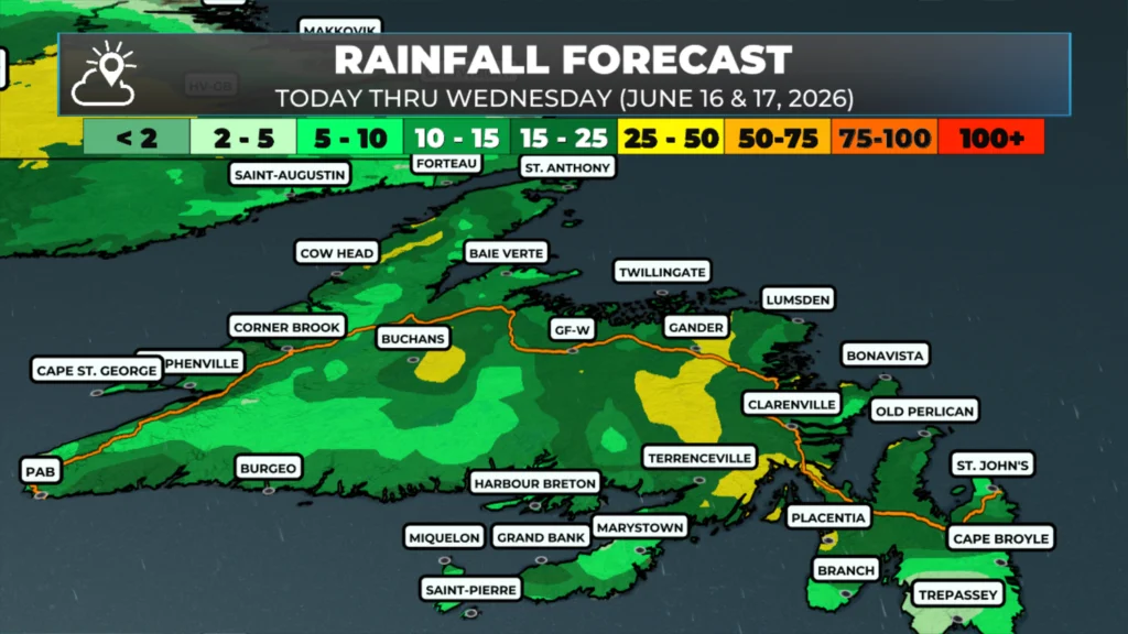
On the Island, the West Coast and Southwest Coast turn wet through the day. Corner Brook can expect around 15 mm of rain through tonight, while Channel-Port aux Basques deals with both rain and strong easterly winds. Gusts near 60 km/h are possible, particularly through the Wreckhouse area.
Further east, most areas from Central Newfoundland to the Avalon stay dry today. There may be some patchy drizzle or fog at times, but the bigger story is the temperature contrast. Inland parts of Central Newfoundland could reach 18 to 21 degrees this afternoon, while coastal areas along the Northeast Coast and Avalon remain stuck in the single digits to lower teens under the marine air.
Tonight, the front pushes eastward across the Island.
Rain spreads into Central Newfoundland this evening before reaching eastern Newfoundland and the Avalon overnight. By Wednesday morning, much of the Island will be dealing with periods of rain, low cloud, and noticeably cooler temperatures.
Rainfall totals of 10 to 20 mm are likely across Central Newfoundland, the Avalon, and parts of the Bonavista Peninsula. The Northern Peninsula may see some of the highest totals on the Island, with areas around St. Anthony approaching 20 mm by Wednesday night.
Temperatures on Wednesday will be a far cry from today’s warmth in Central Newfoundland. Most areas will spend the day in the upper single digits, and a rumble of thunder can’t be ruled out in a few locations as the front crosses the Island.
Meanwhile, conditions improve steadily behind the front. Labrador West clears today and turns warmer Wednesday. Western Newfoundland also dries out through Wednesday, with sunshine returning Thursday and temperatures climbing back toward 20 degrees.
By Thursday, most of Newfoundland and Labrador will be back into drier weather as northwest winds usher in cooler, cleaner air. The end of the week looks fairly quiet, although another system developing upstream bears watching for the weekend.
My next update will be posted later today!
📱 Get the Sheerr Weather App in the Apple App Store and Google Play Store.
🗺️ Check out the Map Room to see all the latest weather observations for the Province.
🎥 Check out the Provincial Highway Cams to see 👀 what’s going on around our highways and
Thanks Eddie for the update! Enjoy your day…
Good morning Eddie and thanks for the update, have a great day