
Tuesday Morning’s Weather Briefing — February 10, 2026
Good Tuesday Morning!
Here are today’s weather highlights:
Areas of snow are currently found across much of Newfoundland, especially on the Avalon and in the northeast. Roads are slick in spots, so keep that in mind as you head out the door. Be sure to check out the Highway Cam page and 511NL.ca
Area of light snow and flurries, drizzle and freezing drizzle will be found throughout much of central and eastern Newfoundland today, particularly along and near north-facing shores.
Highs today near 0ºC for much of the Island, southern Labrador, as low as -8ºC on the north coast and minus teens in the west. There may even be some sunny breaks on the west/southwest/south coasts today.
Wind speeds ramp up for the Avalon Peninsula and northeast coast today, with gusts up to 70 km/h from the northeast.
Snow eases later tonight and tomorrow for many areas, but another low moves in Thursday and will bring another round of mostly moderate snow to a large portion of the Island, and eventually coastal Labrador Thursday into Friday. The West Coast will also see some intense snowfall on Friday.
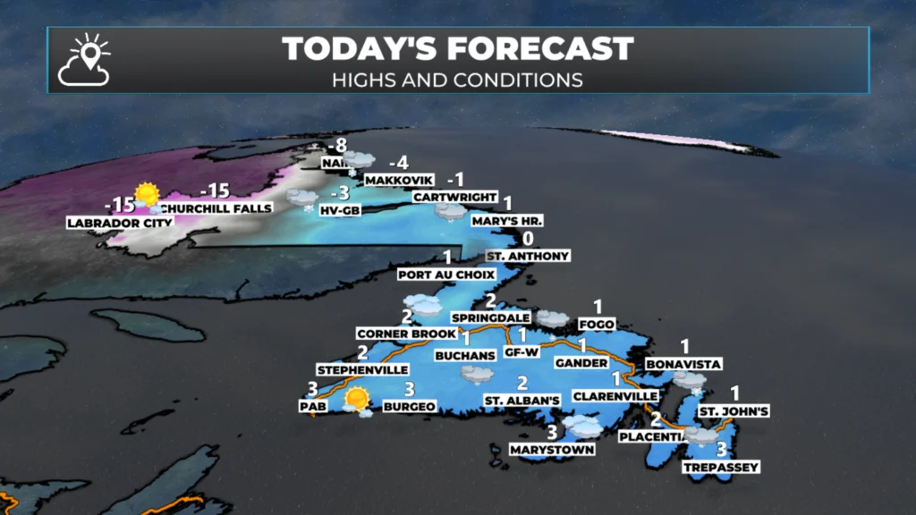
Today’s high and conditions across Newfoundland and Labrador – February 10, 2026.
Periods of snow, drizzle and freezing drizzle will be common across central and eastern Newfoundland today, especially along and near north-facing shores. While significant snowfall isnt’ anticiapted in most areas, locations inland and over higher terrain will see the most snowfall. Roads will be slick in some areas, so keep that in mind as you head out for your daily travels. Areas of the West Coast, Northern Peninsula, South Coast and Southwest Coast will be a bit drier today. In fact, some areas of southwest and southeastern Newfoundland will see some sunny breaks today. Highs will be near 0ºC over much of the Island today.
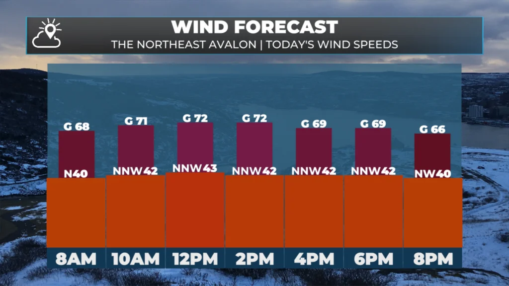
Today’s forecast wind speeds – February 10, 2026
The wind will be a factor this afternoon for northern areas of the Avalon and the northeast coast, with gusts over 70 km/h. I realize the graphic above is only for one spot, but you can use this for all the areas I just mentioned.
Labrador will see areas of snow and drizzle along the coast as well today, with more sunshine the farther west you go. Highs will be near 0ºC in the south, to -8ºC in the North, to near -3ºC in Goose Bay and the minus teens in Churchill Falls and Labrador City.
Future satellite and radar should give you a good idea of how the day’s weather will play out across the Province. Note that we should see a general downturn in the snow and rain activity as the day progresses and tonight. Tomorrow looks calmer across much of the region.
Our next love move in on Thursday will bring another round of snow to the Island and eventually into Labrador, and indirectly back to the western areas of Newfoundland Friday. I’ll have more on this later today.
I’ll have updates for you throughout the day!
📱 Get the Sheerr Weather App in the Apple App Store and Google Play Store.
🗺️ Check out the Map Room to see all the latest weather observations for the Province.
🎥 Check out the Provincial Highway Cams to see 👀 what’s going on around our highways and
Good Morning Eddie. There’s just no end to this winter, is there!!!?
Thanks for all the hours you put in gathering these details for us.
Enjoy your dsy
👍
Thanks Eddie for weather update
Thanks, Eddie. Much appreciated.