The snow we had last evening ended overnight, and the high wind speeds from late evening and overnight are calming down. It was another evening of gusts near 100 km/h across the region. St. John’s International Airport reported a peak gust of 96 km/h. Several other areas on the Avalon, Bonavista, and Burin Peninsulas reported gusts exceeding 100 km/h… again.
Sponsored
Winds quickly ramping up around the intensifying storm centre.
Peak gusts through 9 pm:
124 km/h (Saint-Pierre); 124 km/h (Sagona Island); 121 km/h (Trepassey – Powels Head); 109 km/h (Pass Island); 103 km/h (Cape Pine).#nlwxpic.twitter.com/lEuKFlGUHd
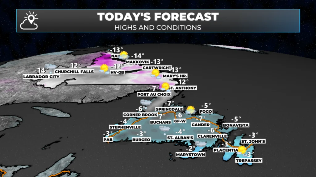
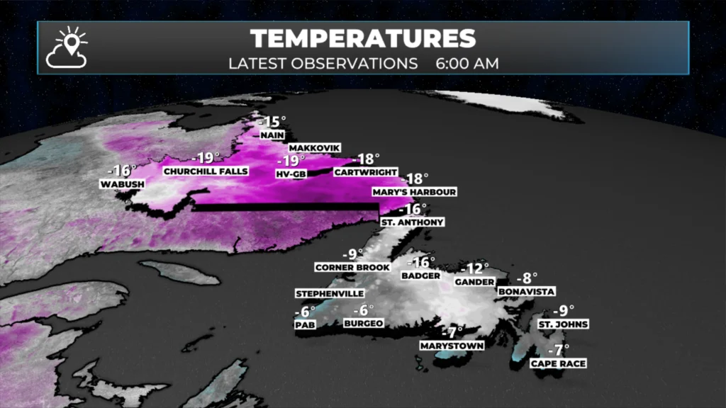
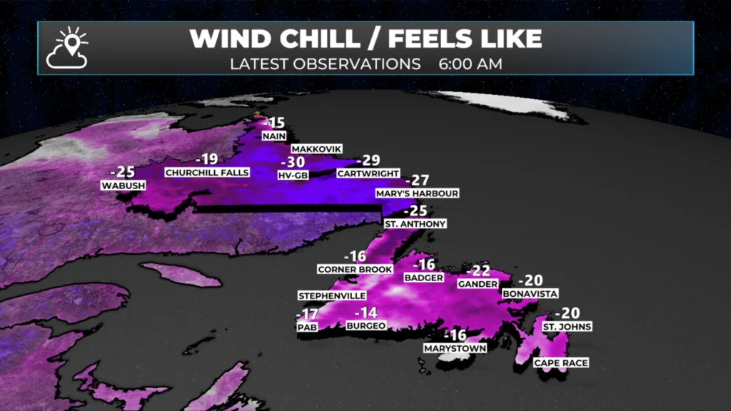
In the wake of this storm, some very cold air has settled in across Newfoundland and Labrador this morning. Temperatures in Labrador are in the mid-teens, while many areas on the Island are near minus ten, with wind chills into the minus teens and twenties as of just before 6 AM NST.
The lowest wind chill on the board seems to be Makkovik at -32ºC. St. John’s is reporting a wind chill of -21ºC with a temperature of -9ºC. As the kids head out the door Province-wide, make sure they’re bundled up for school. As you head out the door, make sure you’re bundled up for the cold!
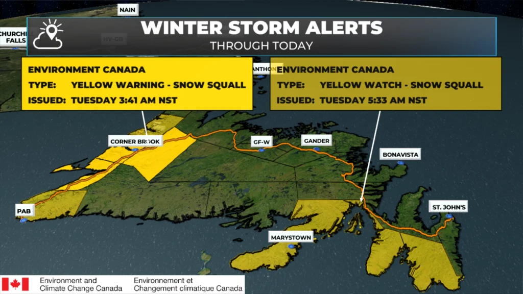
The cold air and westerly flow will generally always lead to the development of onshore snow squalls. A Snow Squall Watch was in effect for much of the West Coast yesterday, and that has now been upgraded to a Snow Squall Warning for the same areas. Remember the difference between a watch and a warning is that a watch means weather conditions are possible, a warning means those conditions are happening.
Snow squalls will not be in every area at all times, but many locations under the warnings will experience winter-storm-like conditions during the squalls. Remember, snow squalls are narrow, just a few kilometers wide, which means conditions can change rapidly if you’re driving through the area, especially from north to south today. This also means that some places that end up under persistent squalls will see heavy snowfall, while areas just a few kilometers away will see hardly any.
This update is sponsored by Roebothan, McKay, Marshall.
Visit MakeTheCall.ca TODAY to learn more about what the law firm can do for you.
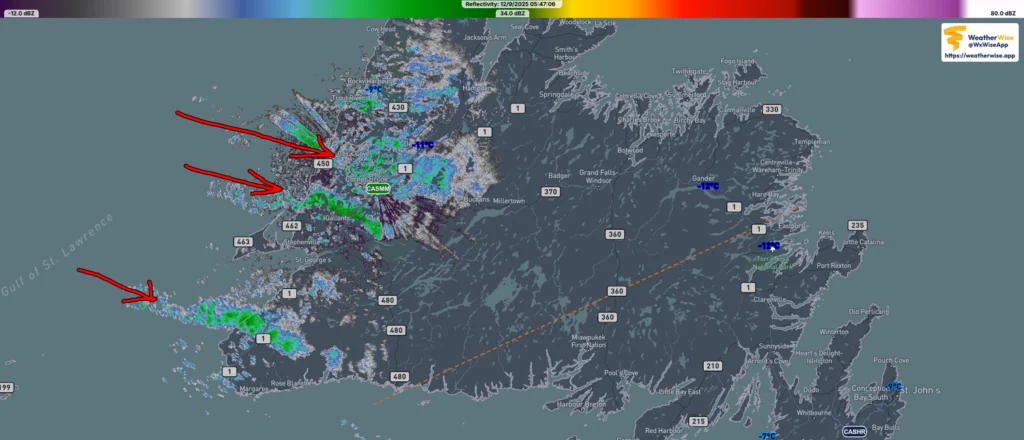
The radar image from this morning shows where the squalls are quite nicely. There is one north of Port aux Basques, a second between Gallant and Corner Brook, and smaller bands near Corner Brook and northward into the Gros Morne area.
Radar Image as of 5:47 AM NST on December 9, 2025. Source: Weather Wise
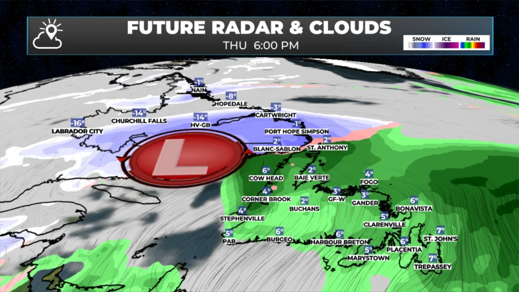
As the day progresses, these squall bands should become more organized and widespread. In fact, there is a chance of flurries and snow squalls today across much of the Island, especially in the south and east, and we may see that watch or warning expanded. Future radar and satellite, below, show this happening very well. It’s those long bands of snow you see in the forecast that are literally hundreds of kilometres long.
Outside of the squalls, the weather across NL will be calmer today. Tomorrow starts similarly, but more light snow and rain will arrive in the evening and into the overnight. That will set the stage for Thursday, which looks snowy in much of Labrador and parts of western/northwestern Newfoundland (looking at you, GNP) and rainy for the rest of the Island. This will be due to a low cutting into the Gulf of St. Lawrence. This system will have some wind with it, but at the moment, it looks like it should be less than the last couple of systems, for the most part.
⚠ Storm ModeGet warnings pushed to your phone the moment they’re issued.Get the app
By using this website, you agree to our use of cookies. We use cookies to provide you with a great experience and to help our website run effectively. Privacy Policy



Thanks Eddie for weather update
It’s a bit nippy this morning, but refreshing as well !!!! It’s where we live !!!! Thanks for the update
🙃
Good Morning Eddie! Another nasty night wind wise, a beautiful, sunny day, from the inside looking out! Have a good day
Thank you Eddie for the update, much appriciated, but I don’t like snow or winter. I’m a summer bird. Stay safe. Have a Blessed day.