WIND WARNINGS, SPECIAL WEATHER STATEMENTS AND COASTAL FLOOD ALERTS ARE IN EFFECT FOR NL. TAP HERE TO SEE THE LATEST ALERTS FROM ECCC …
Sponsored
Good Tuesday morning.
The weather is quiet now, but it will not last. An area of low pressure has begun to develop south of the Island, and as it moves north, it will rapidly intensify into one of the strongest storms the area has ever experienced in November.
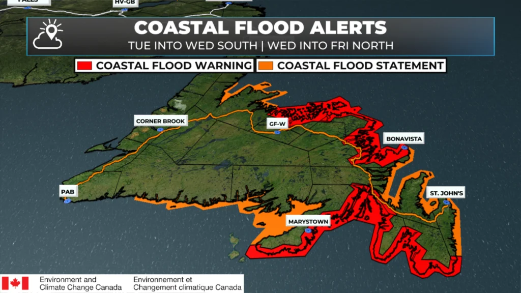
Ahead of the storm, the Environment and Climate Change Canada Weather Office in Gander has updated some alerts and issued new ones. The biggest change is the issuance of COASTAL FLOOD WARNINGS. The southern and western-facing shorelines of the Avalon Peninsula, and the east-facing shores of the Burin Peninsula are under the warning for today. The north-facing shorelines of the northeast coast of Newfoundland, as far west as the Bay of Exploits, are under alert from tomorrow into Friday.
Coastal Flooding Alerts from Environment and Climate Change Canada | 6 AM NST on 11/4/25
I am concerned about the coastal flooding risk for areas of St. Mary’s and Trepassey Bays. Large waves, strong onshore flow, and the potential for significant storm surge mean that low-lying areas may experience water levels rarely seen. The most dangerous time in these areas will be at high tide this evening. If you know you’re in a location prone to coastal flooding, consider moving to higher ground before this evening’s high tide (6 to 8 PM).
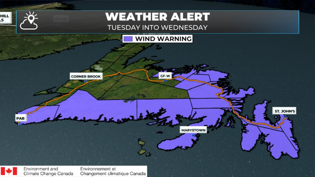
Wind Warnings as of 6 AM on November 4, 2025.
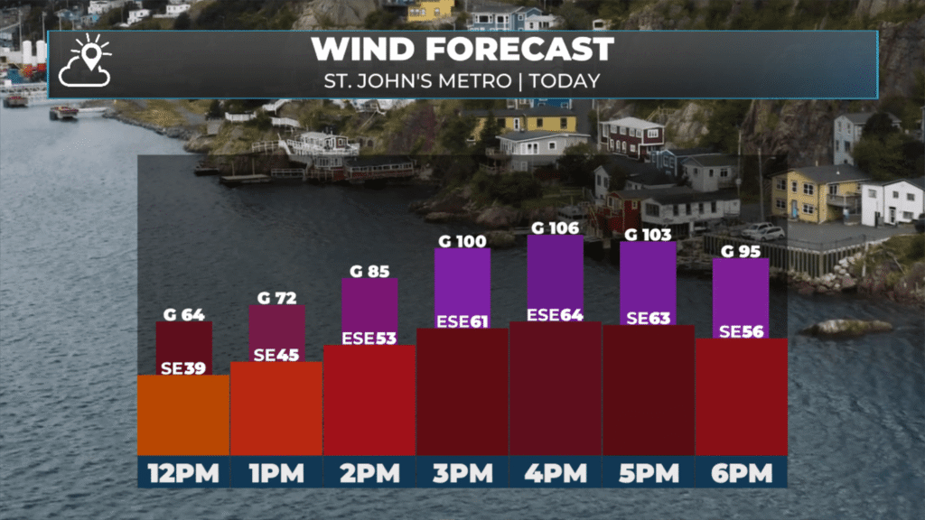
Wind Warnings remain in effect for many areas for today into Wednesday, and have been issued for parts of central and northeastern Newfoundland. Wind speeds are expected to increase this afternoon and persist for several areas into Wednesday. Gusts within the warned areas are expected to reach speeds of 80 to 120 km/h. Locally higher gusts are possible, and it’s also possible that winds will be higher than the alerts suggest.
Forecast winds and gusts for the St. John’s Metro area on 11/4/25
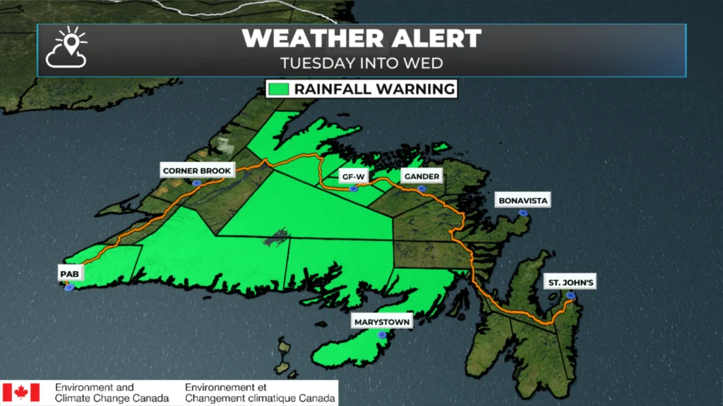
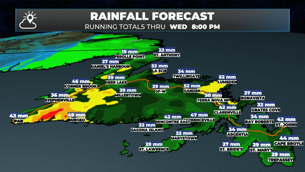
Rainfall Warnings are also in effect for southern and central areas of the Island today, as rainfall amounts in these areas may exceed 50 mm by the time tomorrow afternoon rolls around. These alerts may also need to be expanded west, as the rainfall forecast for western Newfoundland is also quite high.
Rainfall Warnings as of 6 AM on 11/4/25.
The rainfall forecast from today through tomorrow (Nov 4 & 5, 2025)
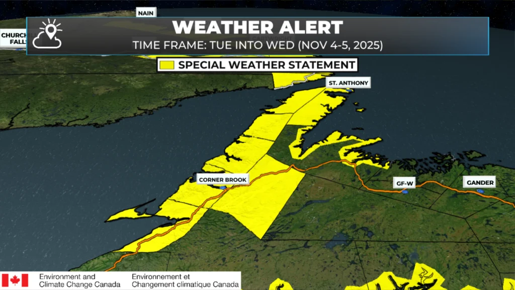
Special Weather Statements also remain in effect for various areas of western Newfoundland and the Northern Peninsula into tomorrow for low elevation rain, high elevation snow, and wind gusting to 80 km/h.
The solid area is the Special Weather Statements. The more narrow shading are the coastal flood alerts (which I cannot parse out). As of 11/4/25 @ 6 AM NST.
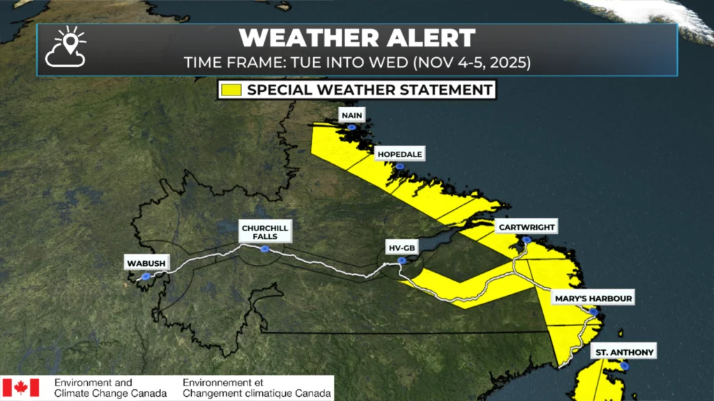
Coastal Labrador is also under a Special Weather Statement from tonight into Friday for heavy rain along the coast, heavy snow in the higher terrain and inland, winds gusting to 100 km/h, and the potential of large waves and storm surge.
Alerts for Labrador as of 11/4/25 at 5:30 AM AST.
I’ll have updates throughout the day and plan to live-stream coverage this afternoon. Check the app and my socials for updates.
Eddie Sheer you’re the bomb when it comes to keeping us well informed when It comes to a meteorological event like the bomb .Keep doing your job which you do from the heart ill be watching@@
⚠ Storm ModeGet warnings pushed to your phone the moment they’re issued.Get the app
By using this website, you agree to our use of cookies. We use cookies to provide you with a great experience and to help our website run effectively. Privacy Policy



Good morning Eddie, thanks for weather update.
Good Morning Eddie! Keep the updates coming …… it is indeed a worrisome forecast. Keep safe all!!!
Thanks so much!!
Thanks for the updates!
Thank you, Eddie.
Thank You….stay safe everyone!!
Thanks Eddie we appreciate the updates. Stay safe everyone.
Thanks Eddie! Outstanding reporting. Stay safe everyone.
Good Tuesday morning Eddie!"…Thank you for the intense weather update!
Stay safe everyone!
Thanks Eddie 😊
I love your app. This app is so informative for the entire island.
Thanks Eddie!
Thanks Eddie good to know , on the road today. Stay safe all .
Thanks Eddie for keeping us informed.
Thanks Eddie for all the detailed info. Greatly appreciated!
Batten down the hatches
Eddie Sheer you’re the bomb when it comes to keeping us well informed when It comes to a meteorological event like the bomb .Keep doing your job which you do from the heart ill be watching@@
Thank you so much for access to this very thorough account of this eeather system affecting us today and in the days to come.
Snowing here in Campbellton. Pretty heavy too!