
Tuesday Morning Update — August 19, 2025
Good Tuesday morning!
Today’s Fire Weather Outlook
The cooler weather over the next few days should be less conducive for fire growth on the Island. While it will be windy, it will be cool and damp. And so while the fires may not get put out by the rain, the growth will be much slower. And with respect to the Kingston Fire, the wind will push the fire into areas that have already been burned. That being said, if there is going to be growth, it will likely be on the south end of the fire, where much of the action has been focused over the last couple of days. This map from CWFIS shows that the most activity has been in the southwest side of the fire (gold stars), and those hot spots were detected by satellite
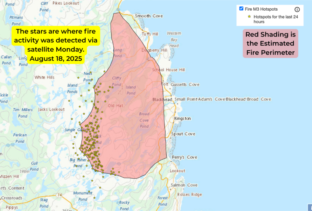
Click to view this map for yourself. Source: https://cwfis.cfs.nrcan.gc.ca/home
The same would be true for the Martin Lake Fire. From the sounds of yesterday’s briefing, the Paddy’s Pond Fire may soon be classified as held as hose lines are almost completely surrounding it now.
This morning’s update is brought to you by Roebothan, McKay and Marshall.

Visit MakeTheCall.ca for more!
We are waking up to an area of low pressure driving areas of rain from the coast of Labrador to the Avalon Peninsula. The heaviest rain, at this hour (5:47 AM) appears to be over the Baie Verte Peninsula. The radar loop shows us what the rain has done over the last few hours.
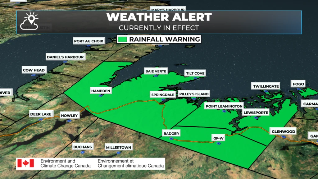
A Rainfall Warning remains in effect at this hour for the following areas:
Grand Falls-Windsor and vicinity
Green Bay – White Bay
Bay of Exploits
Up to 60 mm of rain is expected to have fallen in parts of the warned area by the time it ends this afternoon. According to the warning from the Environment and Climate Change Canada Weather Office in Gander, there are 10 to 15 mm left to fall.
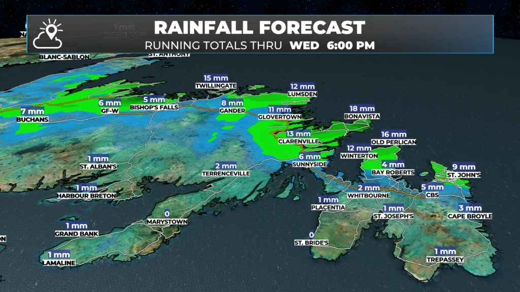
The area of low pressure driving this rain will move east today. As that happens, the rain across eastern and northeastern Newfoundland will become more widespread. This should be more noticeable later this morning. The rain and showers will continue through tonight and into Wednesday morning before ending. Future radar and satellite (below) times this out.
Rainfall amounts will be in the 10 to 20 mm range for much of the Avalon and northeastern Newfoundland over the next 24 hours or so. Amounts will have been much higher farther west, where upwards of 50 mm may have fallen in the Rainfall Warning area.
Temperatures will be cooler across the board today, under and to the west of the low, thanks to winds turning onshore from the north-northwest. Once the winds change to northwest, they will increase, and I expect speeds to be in the 30 to 50 km/h range. The wind speeds will remain relatively high through Wednesday. Below are animations of expected temperatures and wind speeds over the next 48 hours.
Hurricane Erin Update
The Hurricane is Category 3 this morning, packing winds of 195 km/h (120 mph). The Hurricane is located about 1250 kilometers south of Cape Hatteras, North Carolina, and is moving northwest at 11 km/h. Current forecasts continue to indicate the storm will pass southeast of Newfoundland over the weekend.
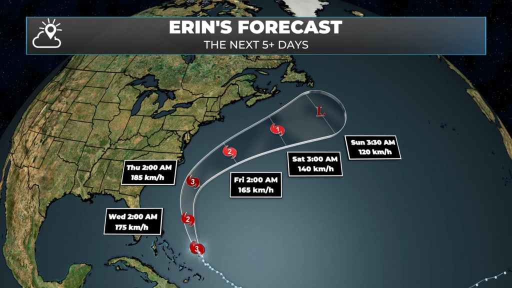
While this will have very little direct impact on the weather in NL, as the storm passes Atlantic Canada, it will generate large waves, and this may impact ferry crossings beginning Friday or Saturday. It may also create hazardous conditions for the recreational food fishery this weekend.
Loving the rain in forecast again today. Let it pour!!
Smoke is really bad in Avalon mall area this morning! Wear a mask, all.
Here in George’s Brook (Clarenville area) we were expecting rain to start last night and continue today, but it went right on by us. Our rainfall total has been downgraded from 25 mm to 13, and I’m wondering if we’ll even get that. It is so parched here, the garden is in desperate need and wells are drying up. Why oh why do the rain clouds keep missing us??
Tks Eddie fir the update
Hi from Port Union, TBN… Praying for rain here and especially where the wildfires are… Just starting here now but we all need lots of it… Been dry too long…
Its very windy the past day in Corner Brook area.. Why might that be?
We need the rain for the wildfires, ponds, rivers and streams, everything is so dry.
We need the rain for the wildfires, ponds, rivers and streams.
Come on with the rain! Lots and lots of it!
Thy Eddie for keeping us updated on conditions forecasted…
🌧 come in rain!!