
Thursday Morning’s Weather Briefing — September 17, 2026

Good Thursday Morning! Here are today’s highlights
Expect a mix of sun and cloud across the Island today, with highs reaching the mid-teens to low 20s.
Labrador will be mostly cloudy and cool, with highs in the upper single digits to lower teens.
A Frost Advisory is in effect for parts of central and western Newfoundland for Friday morning.
A potent low will bring heavy rain and high winds to parts of Newfoundland from late Friday into Saturday. The high winds will occur Saturday.
This morning’s update is sponsored by Roebothan, McKay, Marshall.

Visit MakeTheCall.ca today to learn more about how the law firm can help you!
Newfoundland & Labrador Today
Expect a mix of sun and cloud across Newfoundland today, with high temperatures ranging from the mid-teens to the lower 20s. My forecast indicates that the warmest readings today will be found in the east! Meanwhile, it will be cooler in Labrador after the cold front, with highs reaching the upper single digits to the lower teens this afternoon. I’d be lying if I said today’s forecast wasn’t an easy one!
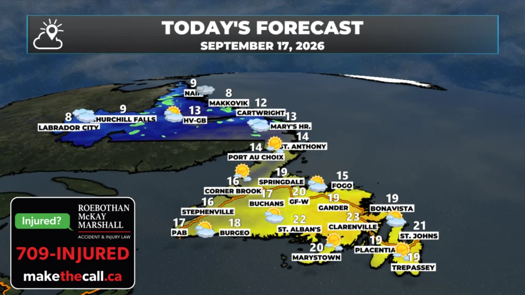
NL’s forecast for today, September 17, 2026.
FROST ADVISORY IN EFFECT
Another thing of note is that ECCC has issued a Frost Advisory (Yellow Level) for the following areas for early Friday morning:
Buchans and the interior
Grand Falls-Windsor and vicinity
Green Bay – White Bay
Deer Lake – Humber Valley
Corner Brook and vicinity
Bay St. George
Patchy frost is expected to form as clear skies and light winds coincide with cool temperatures, especially in low-lying areas. Lows are forecast to be in the +1º to +4º range early Friday morning. The coolest temperatures typically occur shortly before sunrise. Damage to plants, trees, and crops is possible. Cover up plants, especially those in frost-prone areas. Frost advisories are issued when widespread frost or freezing temperatures are expected during the growing season
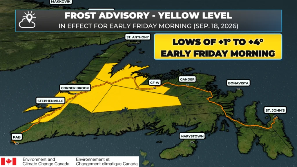
A Frost Advisory is in effect for the highlighted areas early Friday morning.
Late Week Storm Update (Friday into Saturday)
Forecasts continue to indicate that a strong storm will develop over and just northeast of Newfoundland between Friday and Saturday. While this low will bring rain to much of the Island during this time frame, my concern is the strong northerly to northwesterly winds that will develop on the western side of this low as it pulls away from Newfoundland on Saturday. Forecasts continue to indicate that widespread gusts of 70 to 100 km/h are likely across most of the Island (except the West Coast and Northern Peninsula) on Saturday. The highest gusts are expected in the Bonavista Bay area, and if any location will see gusts exceeding 100 km/h, it would be there. There is also a chance that parts of the Burin Peninsula, Fortuen Bay, and areas of the Avalon near Placentia Bay, and even the southern shore, will see high winds on Saturday. Timing will become clearer today and tomorrow. Stay tuned.

My next update will be posted later today right here. Don’t forget to…
📱 Get the Sheerr Weather App in the Apple App Store and Google Play Store.
🗺️ Check out the Map Room to see all the latest weather observations for the Province.
🎥 Check out the Provincial Highway Cams to see 👀 what’s going on around our highways and
Good morning Eddie, thanks for weather update.
Good morning Eddie! Thanks for the update….
Good morning Eddie and thanks for the update
Good morning Eddie, thanks for the update. Have a great day.