
Thursday Morning’s Weather Briefing — May 28, 2026
Good Thursday Morning! I spotted flurries in Torbay earlier…
This morning’s update is sponsored by Roebothan, McKay, Marshall.

Visit MakeTheCall.ca today to learn more about how the law firm can help you!
Here are today’s highlights:
Temps are in the single digits above freezing as we start the day across the Province.
Isolated showers and flurries are found near east and north-facing shores at this hour.
Temps today reach the single digits for eastern and central Newfoundland and teens west and south.
Skies will be cloudy to start for many areas of NL, but will generally become clearer through the day.
Eastern and central areas should see sunny breaks by the afternoon, and the cloud may linger near the east and north-facing shores.
More consistent RDF returns on Friday and Saturday.
Snow chances look lower for Monday… good.
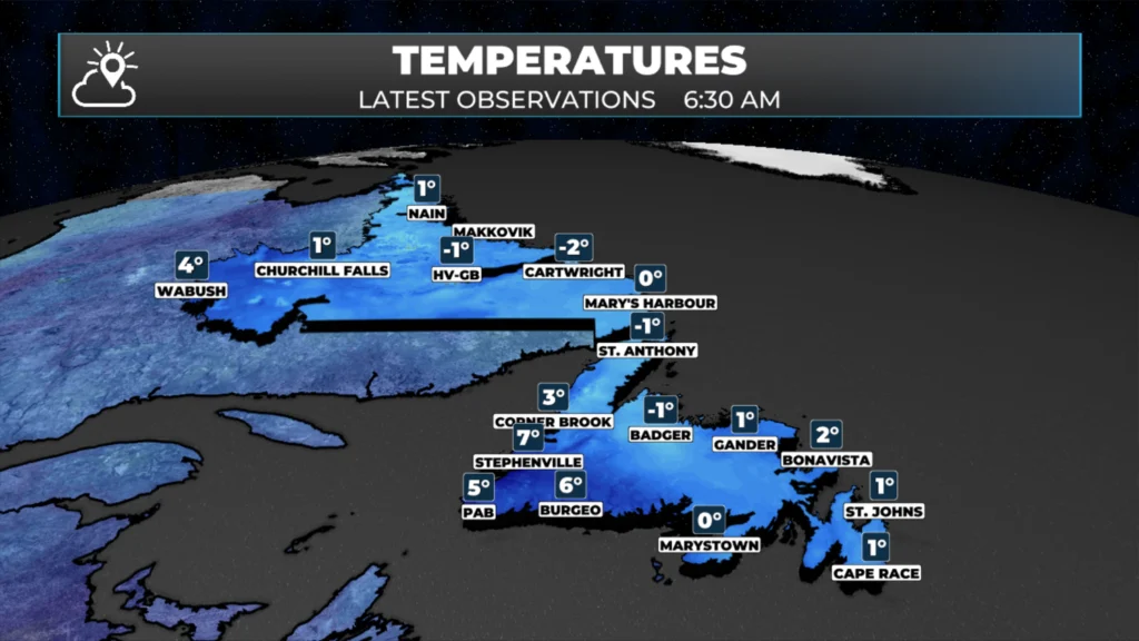
Temperatures as of 6:30 AM NDT on May 28, 2026
That northeast fetch has a grip on most of the Island this morning. St. John’s is at 2°C, with the wind chill around -3°C. A north wind is running at 26 km/h and gusting near 50 — not exactly what you’d hope for in late May.
There were also flurries this morning in the Metro, as seen by yours truly. There is the phrase, “May snow is good for the eyes.” Well, it’s not good for my eyes!
Much of central and northeastern Newfoundland is in the same boat, near 1°C under solid cloud cover to start the day. This is the continuation of the blocking setup that’s been stalling across eastern and central Newfoundland all week.
This morning stays generally overcast for central and eastern Newfoundland. However, I do expect sunny breaks to develop by the afternoon. Where those areas are is the question, and for the moment, I would think just inland from east- and north-facing shores. This will be a situation where it may be foggy in Torbay and sun splittling the rocks in CBS. The same will hold true for central and northeastern Newfoundland. That said, highs will only reach 5-7°C. Overnight, drizzle and fog patches return as another bout of moist air returns. Timing looks to be after midnight. There is even the chance for some freezing drizzle overnight… If you’re heading out on the TCH early Friday, it’s worth knowing before you go.
The West Coast and Southwest Coast are operating in a completely different air mass today. Corner Brook is at 4°C as of 6 AM, still under cloud, but those skies are set to clear through the late morning and afternoon, pushing temps to the mid-teens for highs later today. That’s a significant warmth difference compared to eastern Newfoundland, all courtesy of a gap in the onshore flow on the western side of the Island. Enjoy it while it lasts because by Friday, the cooler air reasserts itself and highs fall back into the 7 to 9°C range across the west. Highs on the Northern Peninsula will mirror the onshore/offshore flow of the east coast vs the west. Locations on the Gulf will peak in the teens, while the east-facing shores will struggle to hit 7º under low cloud, drizzle and fog.
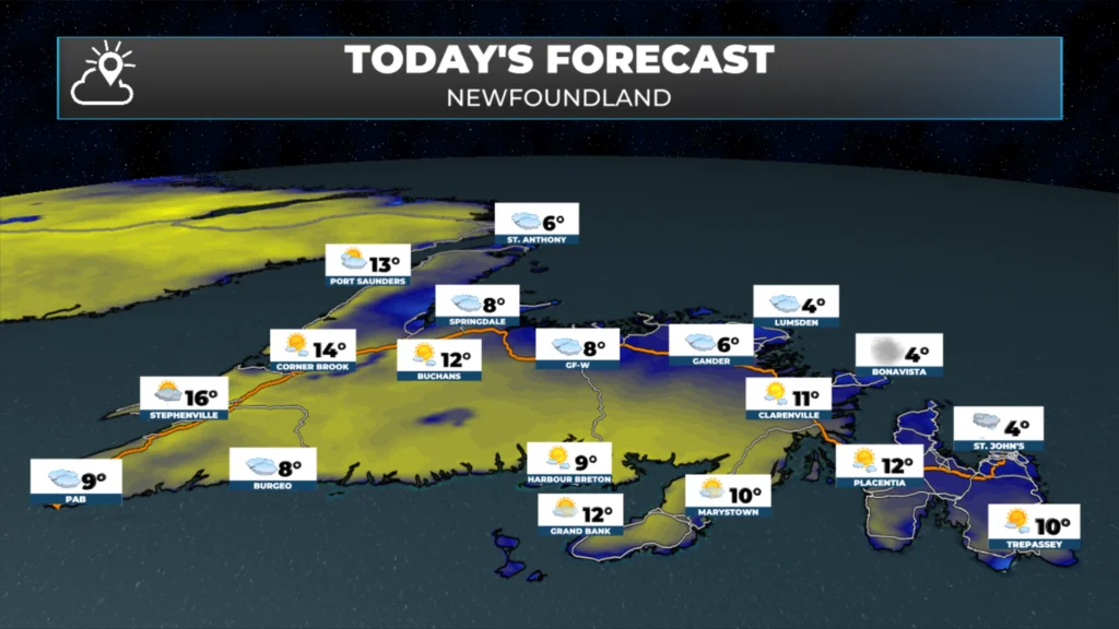
Today’s forecast for Newfoundland – May 28, 2026.
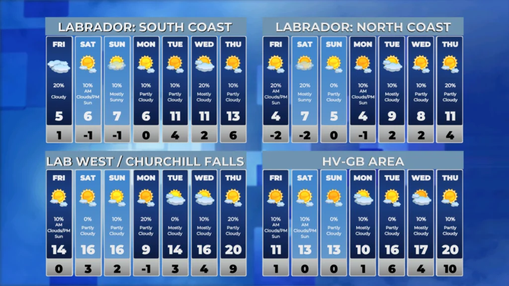
Over in the Big Land, we are seeing a cool start, with temperatures near freezing. Skies will remain partly cloudy to mostly sunny today across much of the area, and highs will climb into the teens. The exception is areas with more clouds than sun, though some breaks should develop in the afternoon. Overall, conditions across Labrador look quiet and reasonable, with cloud cover and mild temperatures from the coast to the interior.
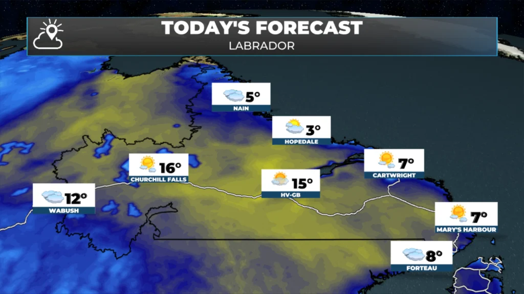
Today’s forecast for Labrador – May 28, 2026.
Looking ahead, the pattern of grinding on eastern Newfoundland isn’t giving up ground quickly. Showers return to the Avalon/Central/Northeast Friday afternoon, and Saturday looks notably unsettled — rain and wind are on tap, and the setup is worth watching if you have weekend plans on the Northeast Coast or Avalon. Highs are locked in the 5 to 7°C range through next week. The West Coast, South Coast and much of Labrador are the exceptions, so if you’re in those spots today, get outside!
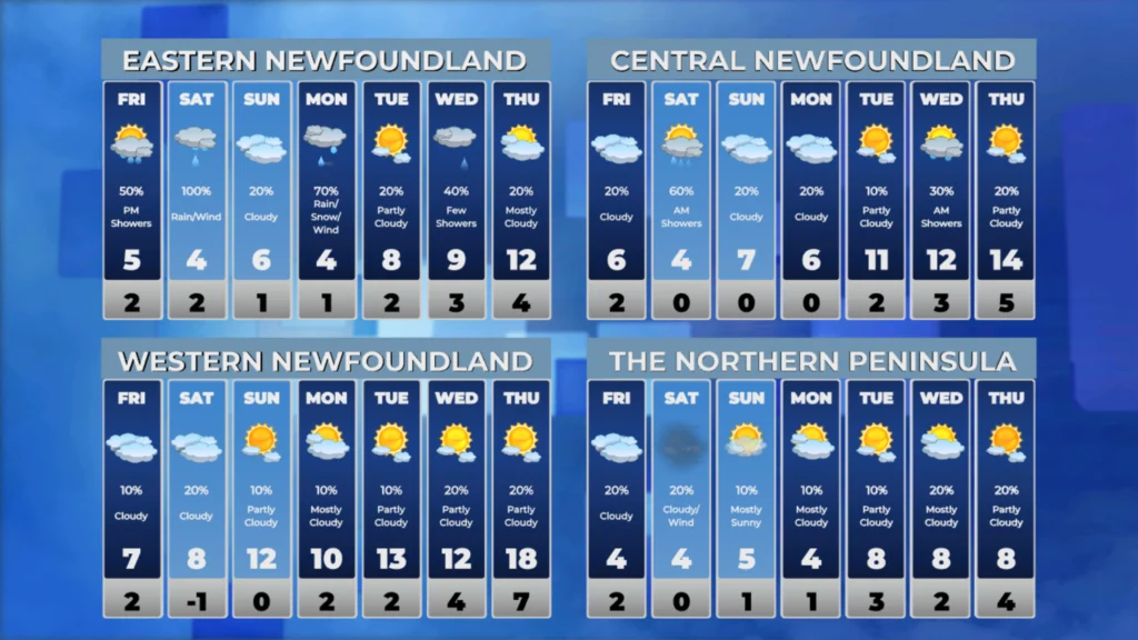
I’ll have my next forecast posted later today!
📱 Get the Sheerr Weather App in the Apple App Store and Google Play Store.
🗺️ Check out the Map Room to see all the latest weather observations for the Province.
🎥 Check out the Provincial Highway Cams to see 👀 what’s going on around our highways and
Good morning Eddie thanks for updating us, have a wonderful day
Excellent update Eddie. It’s killing my eyes too 😀