
Thursday Morning Weather Update — December 11, 2025
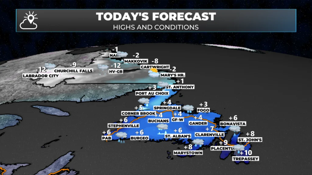
Today’s forecast for Newfoundland & Labrador | December 11, 2025
Good Thursday morning!
We are waking up to milder temperatures across much of the island portion of the province this morning. Readings from the Avalon to Terra Nova, and southwestward toward Bay St. George points south, are already above freezing. To the north, it’s below freezing. Here are the current temperatures as of 6 AM NST.
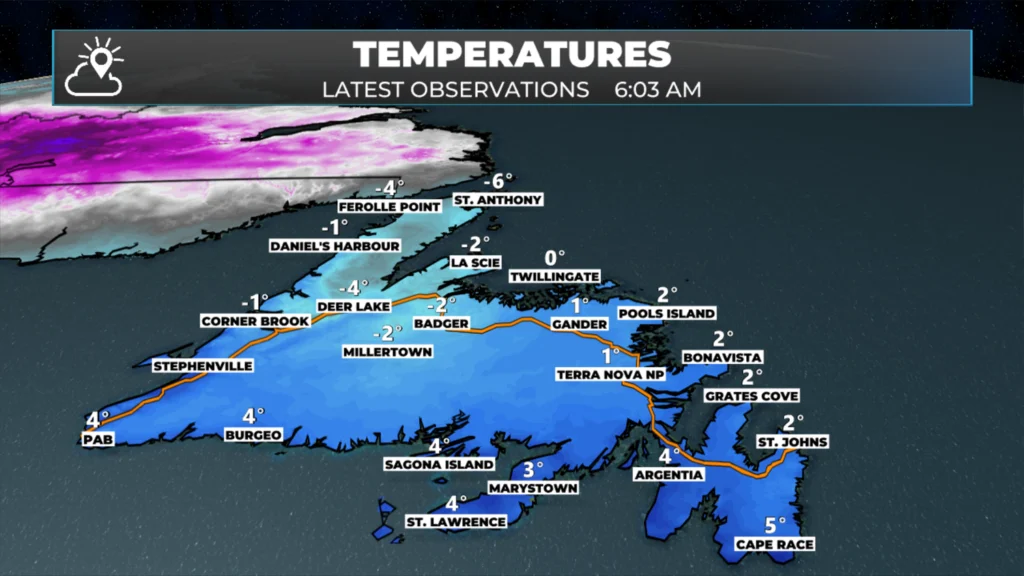
Temperatures as of 6 AM on Dec. 11, 2025
The next area of low pressure we observe will move through between today and Friday. The track of this low will likely be through or near the Gulf of St. Lawrence, then into the North Atlantic by Friday. This will bring a surge of warmer air over much of the Island throughout the day, with some areas already experiencing this. The exception is the Northern Peninsula, where snow is likely to continue today because the warm air doesn’t reach that region. As this low moves through, much of Labrador will see snow, with the heaviest accumulation near the Straits, according to this morning’s outlook.

Future satellite and radar show how the precipitation will play out across the Province today. We will see the warmer air continue its push to the north, which means the colder air will get eaten away, and much of the Island will see rain by later this morning or the afternoon.
The cold will hold on longest on the Northern Peninsula, but even there the snow should mix with rain later today. Meanwhile, in Labrador, the snow will become heavier and steadier in the south and southeast as that moves in this morning. The snow becomes more widespread in the east overnight and on Friday. Speaking of Friday, if you look at the animation above, the warm shot of air on the Island doesn’t last long. The cold air returns Friday, as will snow squalls and flurries for the Island. These will start on the West Coast Friday morning, and areas of southern and eastern in the afternoon.
This update is sponsored by Roebothan, McKay, Marshall.

Visit MakeTheCall.ca TODAY to learn more about what the law firm can do for you.
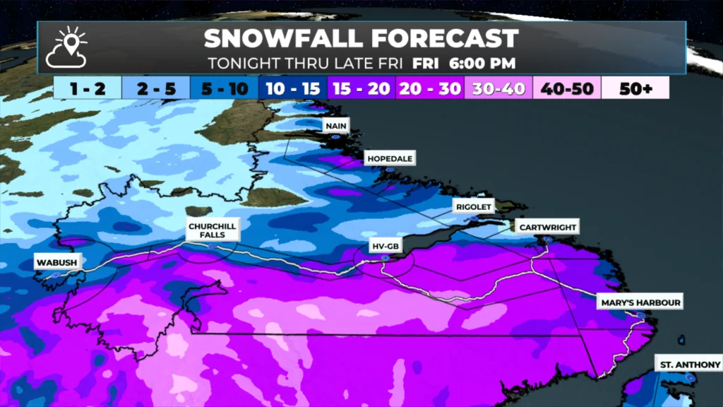
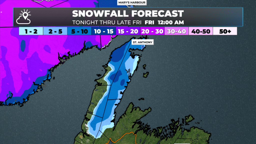
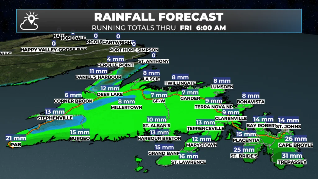
Snowfall amounts between today and tomorrow will be highest on the Northern Peninsula and southern Labrador. Snowfall in Labrador will be in the 15 to 30 cm range in the south, with up to 15 cm on the Northern Peninsula. There may be some isolated pockets of freezing rain as well. Rainfall will be highest over the southern third of Newfoundland, where up to 30 mm will fall between now and later today or tonight.
While there will be some wind today, the only Warning (yellow) is currently in effect for the Wreckhouse area for gusts as high as 100 km/h from the southeast through the day. The wind speeds there will ease this evening. Eastern areas will see gusts from the south around 80 km/h this afternoon, which generally isn’t enough to warrant a wind warning.
Looking Ahead…
The weekend looks fairly quiet, and then we have Monday. The next significant winter storm will move through between Monday and early Tuesday. This low-pressure system will track over or near eastern Newfoundland, which means much of the Island will experience snow, wind, and rain during that period. Rain and snow totals will be substantial, and wind speeds could be quite high, based on current forecasts. Details will become clearer over the next few days, but if you have travel plans early next week, you should stay updated on this forecast.
I’ll have my next update posted later today!
📱 Get the Sheerr Weather App in the Apple App Store and Google Play Store.
🗺️ Check out the Map Room to see all the latest weather observations for the Province.
🎥 Check out the Provincial Highway Cams to see 👀 what’s going on around our highways and
Good morning ☕️Eddie!…Thank you for the weather update!
Stay safe & have a great day!
Good Morning Eddie ☕️. Thank you for your update.
Good morning Eddie thanks for what to look for today weather wise
Thanks Eddie for weather update
Hi Eddie planning to travel to the island next week on Wednesday is this all supposed to be done by then?