Thursday Morning Weather Brief — September 25, 2025
By Eddie Sheerr·
Good Thursday morning!
We are waking up to some crisp temperatures this morning. Readings are mostly in the single digits but seem to be coldest between Badger and Deer Lake on the Island and through the western parts of Labrador.
This morning’s update is sponsored by Roebothan, McKay, and Marshall.
Sponsored
Visit MakeTheCall.ca to learn more about what the law firm can do for you.
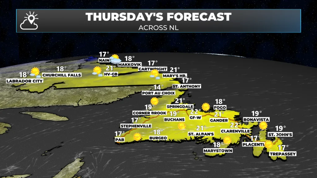
The forecast for today is pretty straightforward. We are expecting lots of sunshine across the Province with above-normal temperatures. Many areas will climb into the teens and 20s today. Be sure to check out the forecast pages to see how warm it will be at your location. The app can also do the same!
Looking Ahead
Tomorrow looks similar temperature-wise across the Island but weather-wise we are looking at some changes. Rain will arrive on the West Coast and Southwest Coast in the morning and spread east throughout the day. The West Coast, GNP, South Coast and Central will see the rain arriving in the late morning or early afternoon. In the east the rain will hold off until the late afternoon or evening. The rain will be heaviest in the south. The rain will end from west to east through the day and into the night. Labrador will also see periods of rain Friday.
Rainfall amounts will be in the 20 to 40 mm range for most areas along and near south-facing shores. Farther north, the totals drop off to between 5 and 15 mm, with some pockets of higher amounts. Rainfall Warnings may be issued for southern areas.
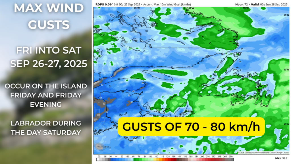
Wind speeds will not be extremely high, but I do expect some gusts of 70 to 90 km/h over various areas of southwestern, southern, and eastern Newfoundland on Friday and Friday evening, extending into coastal Labrador on Friday night and Saturday. This may not be high enough to warrant Wind Warnings being issued by ECCC NL, but it will certainly be noticeable.
Check on the Tropics
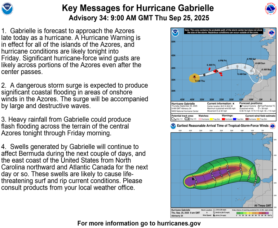
Hurricane Gabrielle continues to spin in the Atlantic toward the Azores, Portugal, and Spain. This poses no threat to NL or Atlantic Canada but is something worth noting.
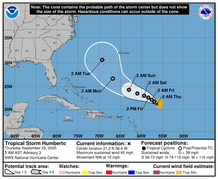
A new tropical storm has developed, and its name is Humberto. Humberto is projected to become a hurriacne by the weekend and must be watched if you have interests from Florida to Atlantic Canada. As of now it’s too early to say to what, if any, impact this storm will have to our region. I’ll watch it closely and you can be sure I’ll have updates on it over the coming days.
My next update will be posted this afternoon on my website. I also post often through the day on my socials!
⚠ Storm ModeGet warnings pushed to your phone the moment they’re issued.Get the app
By using this website, you agree to our use of cookies. We use cookies to provide you with a great experience and to help our website run effectively. Privacy Policy




Thanks again, Eddie
Love your early morning updates, Eddie! Have a good one.
Seize the day, young man!
Thank you, Eddie. Have a great day.
Thank you Eddie. Have a great day!
Good morning Eddie, thanks for weather update.
Thank you !
Tks Eddie for our morning update 🤗
Excellent forecasting!
George S
Thank you Eddie.
Good morning Eddie!…Thank you for the extended forecast!
Have a great day
Loving this new app!!