
Thursday Morning Update — January 22, 2026
Good Thursday Morning!
Here are today’s weather highlights:
Newfoundland & Labrador Hydro has issued a POWER WATCH this morning due to the buildup of frazil ice in the Bay d’Espoir System. No action is needed by the public at this time.
Today will not be as cold as yesterday, but it’s still cold!
Snow arrives on the southwest coast late this morning and spreads east and north through the afternoon
The snow will change to rain before ending overnight on the Avalon and Burin Peninsulas
Friday will generally be a calmer day

This update is sponsored by Roebothan, McKay, Marshall.
Visit MakeTheCall.ca TODAY to learn more about what the law firm can do for you.
Today’s Weather
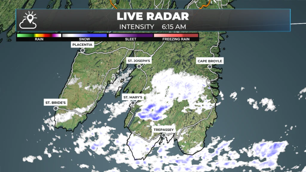
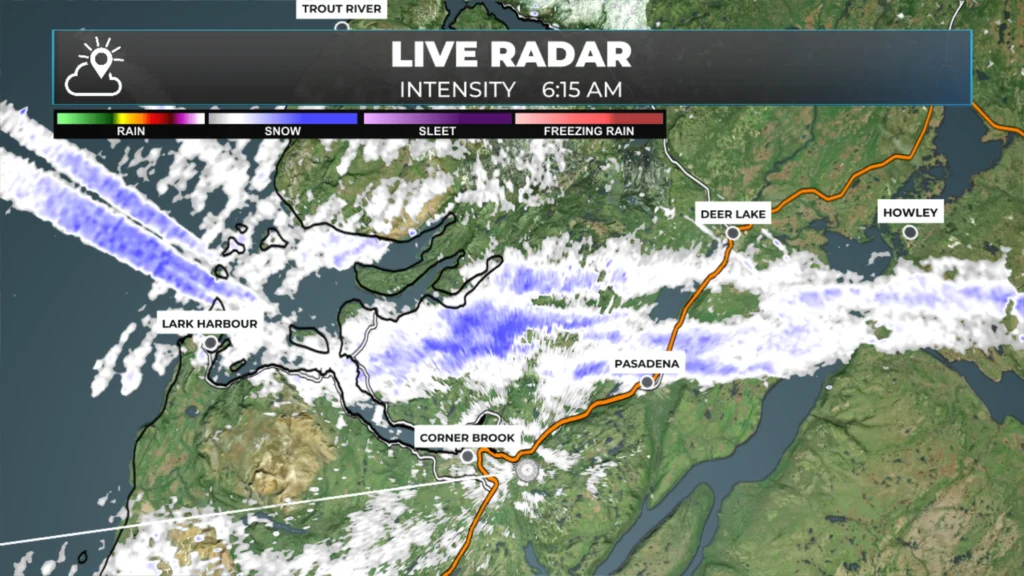
A couple of areas with snow flurries and/or squalls are ongoing this morning. There is one area on the southern Avalon and possibly the Burin Peninsula, and another area on the West Coast between Corner Brook and Deer Lake. All the snow squall-related weather alerts have been ended, and we will continue to see a downward trend in this activity as the morning progresses.
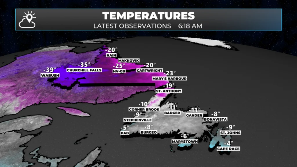
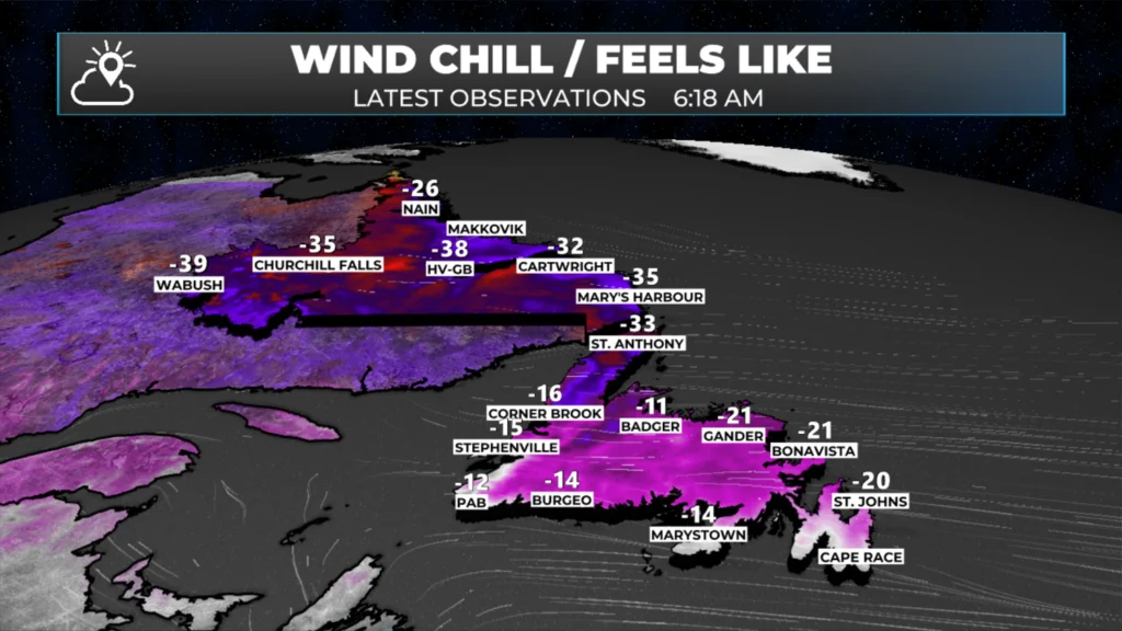
We are off to a cold and breezy start this morning, with temperatures well below freezing and wind chills ranging from the minus teens to nearly -40ºC across the province. Be sure to bundle up when you head out for work and make sure the kids are dressed warmly as they head off to school for the day.
As the day progresses, temperatures will moderate significantly compared to yesterday. Temperatures this afternoon will reach the minus single digits fr highs across most of the Island, while Labrador remains in the minus teens and 20s. Today will not be as windy as yesterday.
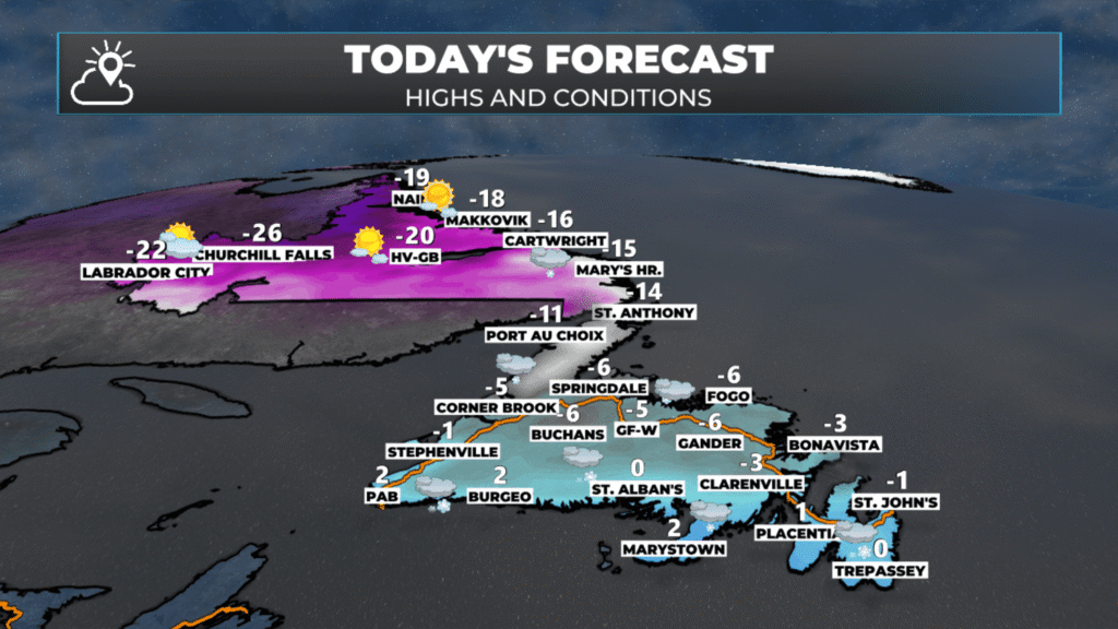
The forecast for today, January 22, 2026.
Our next weather-maker arrives late this morning, and this fast-moving low will bring a period of snow to much of Newfoundland between this afternoon and late tonight. The snow will arrive on the southwest coast late this morning, then spread north and east throughout the remainder of the day. The eastern areas will not see snow until late afternoon or evening. It will be evening in the Metro area. On the Avalon and Burin Peninsulas, the snow will end as rain overnight. The snow will be done in most areas by Friday morning, except in parts of Central and the Northeast Coast, where flurries may linger until near sunrise. Future radar (below) gives you a solid idea of the timing.
You can also find that for your location via the hourly forecast in the Sheerr Weather App!
Snowfall amounts won’t be more than 5 to 10 cm for most areas with this fast-moving system. The exception will be along and near the South Coast, where 10 to 15 cm looks likely.
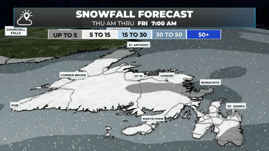
The snowfall forecast from this morning until early Friday morning (Jan 22 to 23, 2026)
I’ll have my next update on Friday’s weather, the weekend and beyond later today!
📱 Get the Sheerr Weather App in the Apple App Store and Google Play Store.
🗺️ Check out the Map Room to see all the latest weather observations for the Province.
🎥 Check out the Provincial Highway Cams to see 👀 what’s going on around our highways and
Good morning Eddie, thanks for weather update.
Good morning ☕️Eddie & thank you for the update!
The high winds snow & Blowing snow has been relentless the last few days here on the West Coast!..Have a great day!
Good morning Eddie thanks for the update have a great day
Thanks Eddie.Have a good day.
Thanks for the weather update. I find your weather app well done!
Environment Canada only saying 2 to 4 CMS even for central nfld out to Clarenville , I find this app inaccurate
My app says 3-7 cm for Clarenville… so really not much different. Let me know what you get, please!
Well you say up to 15cm is possible in central nfld including Grand Falls Windsor, that’s quite different from Environment Canada saying 2 to 4, I know we may get it but just an observation
I said, “snowfall amounts won’t be more than 5 to 10 cm for most areas.”
The exception is the south coast where it will be as much as 15 cm.
The map says 5 to 15 as those are the pre-defined ranges and its model data.
Good Morning Eddie! A somewhat half decent forecast…… until later in the day. Thanks for ALL your updates ….. you’re an extremely busy meteorologist!
Thank you Eddie! We really appreciate your dedication to keep us all informed!!
Thanks for keeping us in the loop, and explaining the unknown like Frazil ice… learn something new everyday 🤔
Needs more snow Eddie for a ski doo run. See what ya can doo fir me.