
Wind Warnings and Coastal Flood Statements Issued By Environment Canada Ahead of Early Week Storm
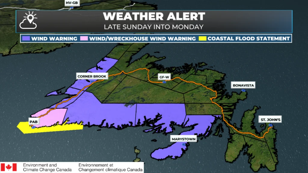
Environment Canada has issued multiple weather alerts for Newfoundland, as a strong low-pressure system will start to spread its weather impacts into the region late Sunday afternoon and Sunday night. Currently, the alerts include a Coastal Flooding Statement and several Wind Warnings. I expect more alerts to be issued tomorrow (Sunday). Below is a summary of what each alert means and when conditions are expected to peak.
Coastal flooding statement
Locations: Isle aux Morts – La Poile; Cape Ray – Channel‑Port aux Basques
A Coastal Flooding Statement has been issued for the southwest coast because a storm surge and an astronomical high tide could push water levels above the highest astronomical tide. The most significant effects are expected on Monday morning, particularly around high tide between 6:00 AM and 9:00 AM. Residents in low-lying areas should be prepared for flooding and protect vulnerable infrastructure.
Wind warning — South Coast
Locations: Burin Peninsula; Connaigre; Burgeo – Ramea; Channel‑Port aux Basques and vicinity
A wind warning is in effect for the south coast of Newfoundland from Channel‑Port aux Basques to the Burin Peninsula. Strong east‑to‑southeasterly winds will build on Sunday evening and continue into Monday morning, with gusts reaching 100 km/h. The winds will develop in the southwest first and spread eastward overnight, bringing the strongest gusts along the coast. Utility outages and travel disruptions are possible.
Wreckhouse wind warning
Location: Channel‑Port aux Basques and vicinity (Wreckhouse area)
A Wreckhouse Wind Warning has been issued for the Channel‑Port aux Basques area. Very strong southeasterly winds are expected Sunday evening through early Monday morning, with gusts up to 140 km/h. Such winds can overturn high‑sided vehicles; motorists are urged to avoid the Wreckhouse corridor during peak winds and allow extra time for travel.
Wind warning — west coast
Locations: Bay St. George; Corner Brook and vicinity; Gros Morne
Another wind warning covers the west coast of Newfoundland from Channel-Port aux Basques, northward to Gros Morne. A period of strong southeasterly winds is expected overnight Sunday night until Monday morning, with gusts around 80 km/h and possibly 110 km/h in exposed areas. Local enhancements to the wind are common near Cape St. George, Port au Port Bay, the outer Bay of Islands, Trout River Bay, Bonne Bay, Western Brook Pond and St. Paul’s Bay. Loose objects should be secured and residents should be prepared for potential property damage or outages.
Stay informed
These alerts were issued on Saturday, Nov 15, 2025, and apply to weather conditions expected Sunday night and Monday. For the latest updates in your area, you can use the Sheerr Weather App and/or the Environment and Climate Change Canada Weather Alert Page.