
Orange, Yellow Level Winter Storm Watches Issued for Eastern and Central Newfoundland for Monday into Tuesday
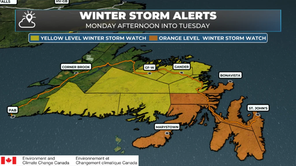
Winter Storm Watches in effect as of Sunday morning – March 22, 2026
Environment Canada has issued an Orange Level Winter Storm Watch for the following areas from Monday evening until Tuesday night:
St. John’s and vicinity
The Avalon Peninsula North
The Avalon Peninsula Southeast
The Avalon Peninsula Southwest
Burin Peninsula
Clarenville and vicinity
Bonavista Peninsula
This Winter Storm Watchis in effect for southeastern Newfoundland, where a significant and complex system is expected to arrive Monday evening and continue through Tuesday night. Snow will develop Monday evening and, combined with strengthening easterly winds, will lead to poor visibility in blowing snow overnight into Tuesday morning.
Current projections suggest total snowfall amounts in the 30 to 50 cm range. As temperatures rise above freezing on Tuesday, precipitation will transition from snow to ice pellets and freezing rain, eventually changing to rain. This is most likely to occur on the Avlaon Peninsula, and forecasts indicate it will occur on Tuesday morning after significant snowfall.
As colder air returns Tuesday night, precipitation is expected to switch back to snow, bringing a second period of reduced visibility in blowing snow.
Winds will increase as the system intensifies, with easterly gusts reaching up to 60 km/h on Tuesday before shifting to the west and strengthening to 80–100 km/h Tuesday night.
A Yellow Level Winter Storm Watch is in effect for the following areas from Monday night until Tuesday night:
Terra Nova
Bonavista North
Gander and vicinity
Grand Falls-Windsor & vicinity
Bay of Exploits
Buchans and the Interior
Connagire
Burgeo – Ramea
This Winter Storm Watch covers southern, central, and northeastern Newfoundland, where conditions are also expected to deteriorate Monday night and persist through Tuesday night. Snowfall totals in these areas are currently estimated between 20 and 30 cm, with strong northerly winds gusting between 80 and 100 km/h. Even stronger winds are possible along coastal areas.
While eastern areas may see snow mix with ice pellets and freezing rain Tuesday morning, much of this region is expected to remain predominantly snow. Although Environment Canada is currently calling for 20 to 30 cm, there is growing confidence on my end that some areas could exceed that range. In particular, between Terra Nova, Gander, and Bonavista North, current projections suggest a 70–80% chance of snowfall totals surpassing 30 cm.
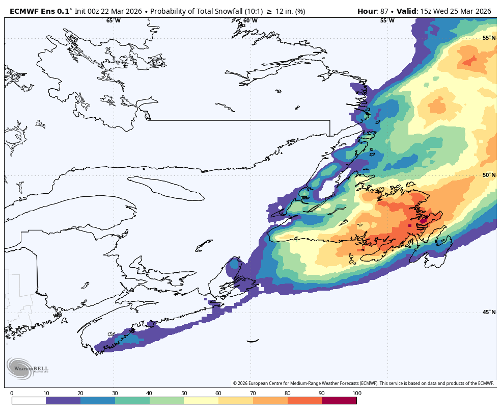
The chances of 30 cm of snow, or more, between Monday and mid-morning Wednesday
These conditions will likely lead to widespread poor visibility in blowing snow, with the potential for localized blizzard conditions in some areas. Visibility may be suddenly reduced to near zero at times, and travel delays or disruptions are possible. Residents are encouraged to closely monitor forecasts and alerts from Environment Canada as this system continues to evolve.
📱 Get the Sheerr Weather App in the Apple App Store and Google Play Store.
🗺️ Check out the Map Room to see all the latest weather observations for the Province.
🎥 Check out the Provincial Highway Cams to see 👀 what’s going on around our highways and
Good morning Eddie, thanks for weather update.
Yikes!! Thanks for the update! Guess all will be getting storm chips today!!!
Good Sunday morning ☕️ Eddie ..Thank you for the weather update!
Have a great day!…Stay safe!
Omg not another one. Will it ever stop. Thanks very much Eddie, now we know we can’t plan much for Monday or Tuesday . That’s ok, we will overcome. Lol
Have a good day and keep up the good work.😀😀😀
Thank you, Eddie; but please make it stop.
In like a Lamb out like a Lion…..ROAR!
Thanks Eddie , but this crap weather makes it so hard to keep appointments ….grrrr lol
Oh dear Lord! I am so done with winter/snow!
Thanks Eddie hopefully we won’t get too much here in CBS
So once the snow turns to freezing rain Tuesday morning and then the temps change ,so the precipitation changes to snow blowing snow and high winds but didn’t mention about accumulation of snow Tuesday evening/Night!!?? Any predictions!!!? AWESOME PROGRAM,THANKS 👍