
Monday Morning’s Weather Briefing — October 26, 2026

Good Monday Morning!
- A mild start to the week for eastern Newfoundland, with sunshine and highs of 13 to 15 on the Avalon, the Burin and around Clarenville and Bonavista.
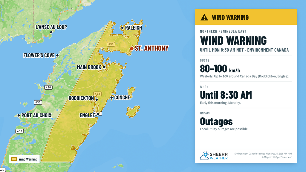
- Rain moves across western Newfoundland today, with around 5 to 10 mm for the Bay St. George area and Gros Morne. A Wind Warning for the Northern Peninsula East ends early this morning, after gusts to 96 km/h at Englee overnight.
- Showers reach the east this evening, then a light rain overnight, with just 1 to 3 mm.
- Much colder air follows on Tuesday: highs of only 2 to 7, gusty northwest winds, and flurries possible over the higher terrain of the west.
- In Labrador, a cool, cloudy day with a few flurries in Lab West, highs of 2 to 8, and windy conditions along the North Coast.
It’s a mild start to the week across much of Newfoundland. Just after 4:30 AM, it was 7 in St. John’s, 9 in Bonavista and Twillingate, 8 in Gander, Corner Brook and Stephenville, and 3 in Burgeo, with southwest winds ushering in some warmer air ahead of a cold front. For the eastern half of the Island, today looks like one of the nicer days we’ll see for a while, so if you have anything to get done outside, today’s the day.


That cold front is the big story. It brings rain to western Newfoundland this morning, with around 5 to 10 mm for the Bay St. George area and Gros Morne, up to 11 mm over the Lewis Hills, and 1 to 3 mm for Corner Brook and Deer Lake. It’s windy on the Northern Peninsula too, where southwest winds of 30 to 50 km/h could gust over 65 at times, and up to 80 along the northwest coast and the Straits.

The front crosses the Island today and reaches the east this evening, bringing showers that become a light rain overnight. Amounts look light, mostly 1 to 3 mm. Behind it, the wind shifts to the northwest and much colder air pours in. Tuesday’s highs are only 2 to 7 across the Island, and near or below the freezing mark over the higher terrain of the Long Range Mountains, where a few flurries or snow showers are possible. With northwest winds gusting over 65 km/h on Tuesday along the West Coast, the South Coast and the Northern Peninsula, it’ll feel a lot more like November.
Environment Canada’s Wind Warning remains in effect for the Northern Peninsula East until early this morning, with maximum westerly wind gusts of 80 km/h, except 110 in the Canada Bay area. Local utility outages are possible, so secure loose objects. Overnight, Englee gusted to 96 km/h around 11:30 PM, with 78 at St. Anthony and 77 at Ferolle Point.
Eastern Newfoundland / the Avalon: Sunshine and a few clouds, with highs of 13 to 15 in St. John’s and on the Southern Shore, and 11 on the western Avalon. Southwest winds 25 to 40 km/h. Showers this evening, becoming a steady light rain overnight, with 1 to 3 mm and lows near 5 or 6. Sunshine and clouds around Clarenville and the Bonavista Peninsula, with highs of 15 to 16, then a few showers tonight, with lows of 2 to 4. Tuesday turns colder, with highs of 6 to 8 and northwest winds 25 to 40.
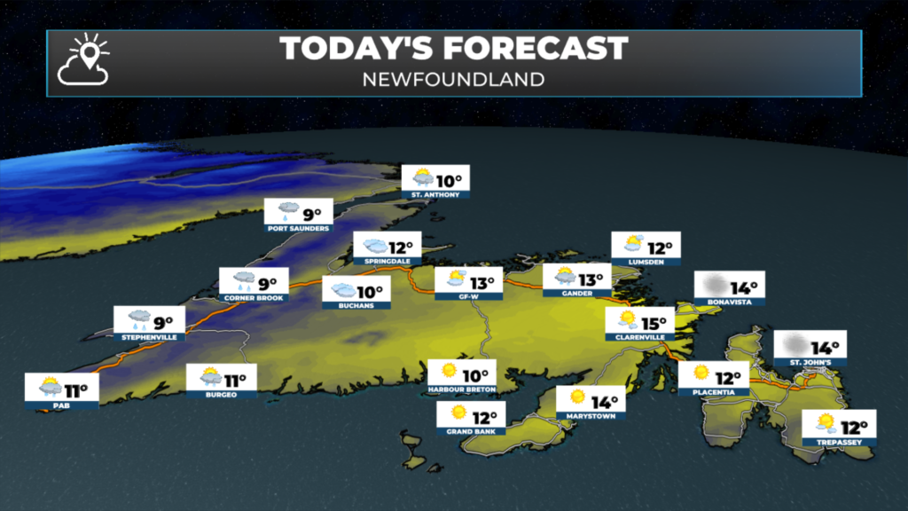
Central: Partly cloudy this morning, becoming cloudy this afternoon in Gander, the Exploits Valley and Notre Dame Bay, with a few showers in Gander and highs of 12 to 13. Southwest winds 15 to 40 km/h. Showers ending this evening, with lows near 0 to 2. Partly cloudy and much cooler Tuesday, with highs of 3 to 5.
West Coast: Rain in the Bay St. George area today, with around 6 to 9 mm. A steady rain this morning in Corner Brook and Deer Lake, then showers this afternoon. Highs of 9 to 11, with southwest winds 15 to 30 km/h. Clearing late tonight, with lows near 0 to 2. Tuesday is much colder, with highs of 2 to 5, a few flurries possible around Corner Brook, and northwest winds gusting over 65 in the Bay St. George area.
South Coast: Mostly sunny on the Burin Peninsula, in Bay d’Espoir and on the Connaigre Peninsula, with highs of 10 to 14. Showers develop later in the day in Burgeo, where it reaches 11. Light rain this evening and overnight on the Burin, with 1 to 3 mm and lows of 3 to 5. Windy and colder Tuesday, with northwest winds 30 to 50 km/h and highs near 6.
Southwest / Wreckhouse: Partly cloudy, then increasing cloud with showers later in the day in Port aux Basques, with a high near 10. West winds 15 to 30 km/h. Tuesday brings partly cloudy skies, a high near 5, and gusty northwest winds of 40 to 55 km/h, occasionally gusting over 65. Northwest winds don’t usually cause trouble at Wreckhouse, but you can always check the Wreckhouse Wind Gauge before you travel.
GNP and the Straits: Cloudy and windy, with periods of rain early, ending this afternoon. About 5 mm on the southern part of the peninsula. Southwest winds 30 to 50 km/h, gusting over 65, and 40 to 55 in the Straits. Highs near 9. Windy tonight too, with lows near 0 to 2. Tuesday is windy with increasing clouds and a high near 4.
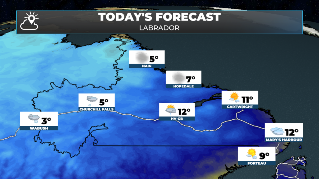
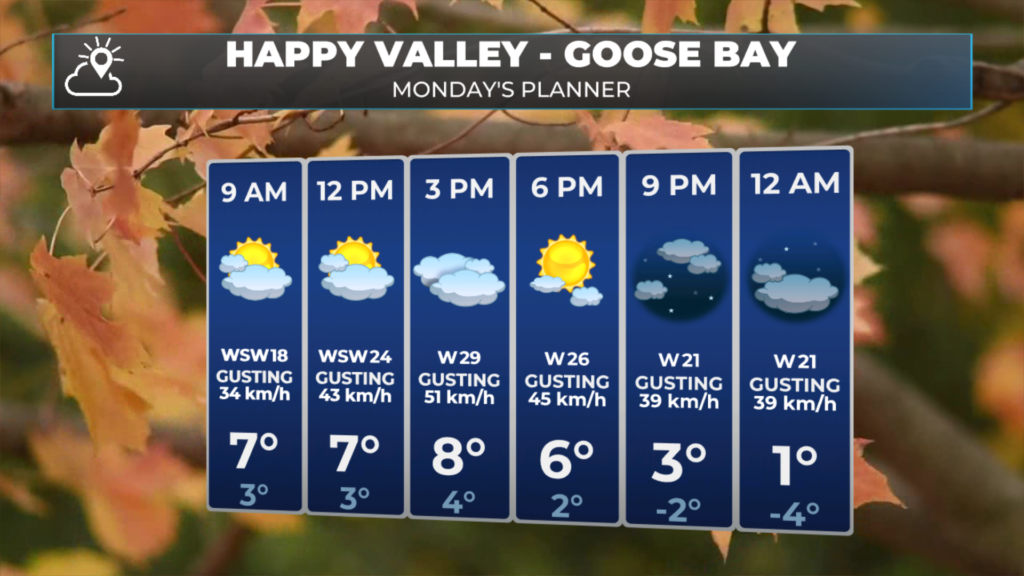
Labrador / the Big Land: Snow showers this morning in Lab West, with temperatures near 4 this morning falling to minus 2 to 0 this afternoon. Cloudy with a few snow showers in Churchill Falls, with a high near 5. A few showers this morning in Goose Bay, with a morning high of 12 and temperatures falling to 4 to 6 this afternoon. Windy along the North Coast, with west winds 30 to 55 km/h, gusting over 65 in Nain, Hopedale and Makkovik, and highs of 5 to 9. Partly to mostly cloudy along the southeast coast, with highs of 8 to 11. Colder tonight, with lows of minus 1 to minus 5. Tuesday brings snow to the North Coast, with 2 to 3 cm around Postville and Makkovik and gusts over 80 km/h in Hopedale, and highs of only minus 2 to 4 across the Big Land.
Looking ahead: Tuesday is the coldest day of the week so far, with highs of 2 to 7 on the Island and a raw northwest wind. There’s nothing major in the forecast for the rest of the week for now, but it’s a reminder that winter is knocking on the door, so it might be time to think about those snow tires.
📱 Get the Sheerr Weather App in the Apple App Store and Google Play Store.
📍 Want more detail for where you live? Check out our new Regional Forecast pages for current conditions, local alerts, highway cams and the forecast for your area: Avalon · Eastern · Burin Peninsula · South Coast · West Coast · Long Range Mountains · Central · GNP & the Straits · Labrador West · Central Labrador · Labrador North Coast · Labrador South Coast
🗺️ Check out the Map Room to see all the latest weather observations for the Province.
🎥 Check out the Provincial Highway Cams to see 👀 what’s going on around our highways.
Good Monday morning. Love reading your weather updates. Great job.
Thank you!