
Monday Morning’s Weather Briefing — May 4, 2026

Forecasts, alerts & live weather for Newfoundland and Labrador
A potent area of low pressure will move through the region today, bringing rain, snow and moderately high wind speeds into early Tuesday.
Wind speeds for much of the Island will gust as high as 80 to 90+ km/h today into tonight, including the Metro area.
The Northern Peninsula will see somewhat lower wind speeds today; however, they will increase rapidly tonight as the low begins to depart into the North Atlantic.
Rain showers and wet snow flurries, along with a few sunny breaks, will be the rule across Newfoundland today, while rain and snow will fall in Labrador. And some of the snow will accumulate. A Special Weather Statement is in effect for the Happy Valley-Goose Bay / Upper Lake Melville area for up to 10 cm of snow today.
Keep scrolling to read more!
This morning’s update is sponsored by Roebothan, McKay, Marshall.

Visit MakeTheCall.ca today to learn more about how the law firm can help you!
Today’s Forecast
A potent area of low pressure that brought heavy rain, snow and wind to the Maritime Provinces yesterday is moving into Newfoundland and Labrador this morning. The low is currently situated over the northwest corner of Cape Breton Island in Nova Scotia and is moving northeast. The satellite and radar animation (below) shows the circulation clearly.
While there are some areas of rain and wet snow falling across the Island this morning, generally, this low will not be a big precipitation-maker for the Island, as it’s a weakening low. However, it will be a solid wind-maker and much of the Island will see gusts to 80 or 90 km/h from the southwest or west later today into tonight. The metro area will see the winds peak this afternoon.
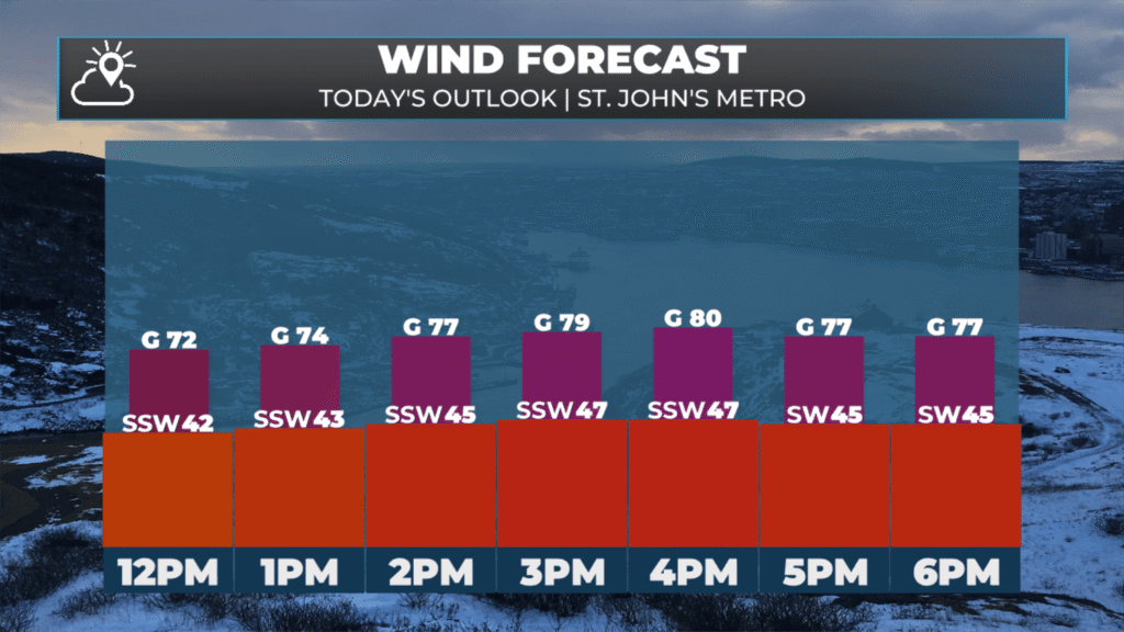
Today’s expected wind speeds, gusts and direction for the St. John’s Metro area.
The rest of Newfoundland and even parts of Labrador will see winds peak today or tonight. The Northern Peninsula, for example, will see those winds peak overnight into early Tuesday. Tuesday also looks breezy, but it will not be as windy as today.
It will be a different story in Labrador, where rain and wet snow will fall today. Future satellite and radar show this well. Note the lack of moisture on the Island and the very stratiform rain and snow over Labrador.
While most areas will not see significant snowfall today, the area between Upper Lake Melville and Churchill Falls will. In the lower elevations, including near Goose Bay, expect 5 to 10 cm of heavy wet snow, while higher terrain may see up to 20 cm. If you have plans to drive between those two areas today, please keep that in mind.
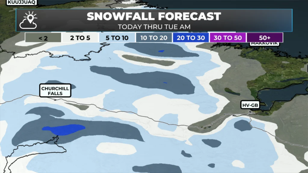
The snowfall forecast shows a rough 5 to 10 cm between Goose Bay and Churchill Falls today into Tuesday.
Temperatures today will generally peak in the lower to middle single digits across the Province, although it will feel cooler due to the wind.
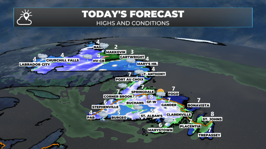
Today’s forecast for NL – May 4, 2026.
A significant warm-up arrives after today, with highs expected to be in the middle to upper teens, dare I say 20º this week! This example below is for the Metro, and if we see near 20º there, we know other areas will be even warmer!
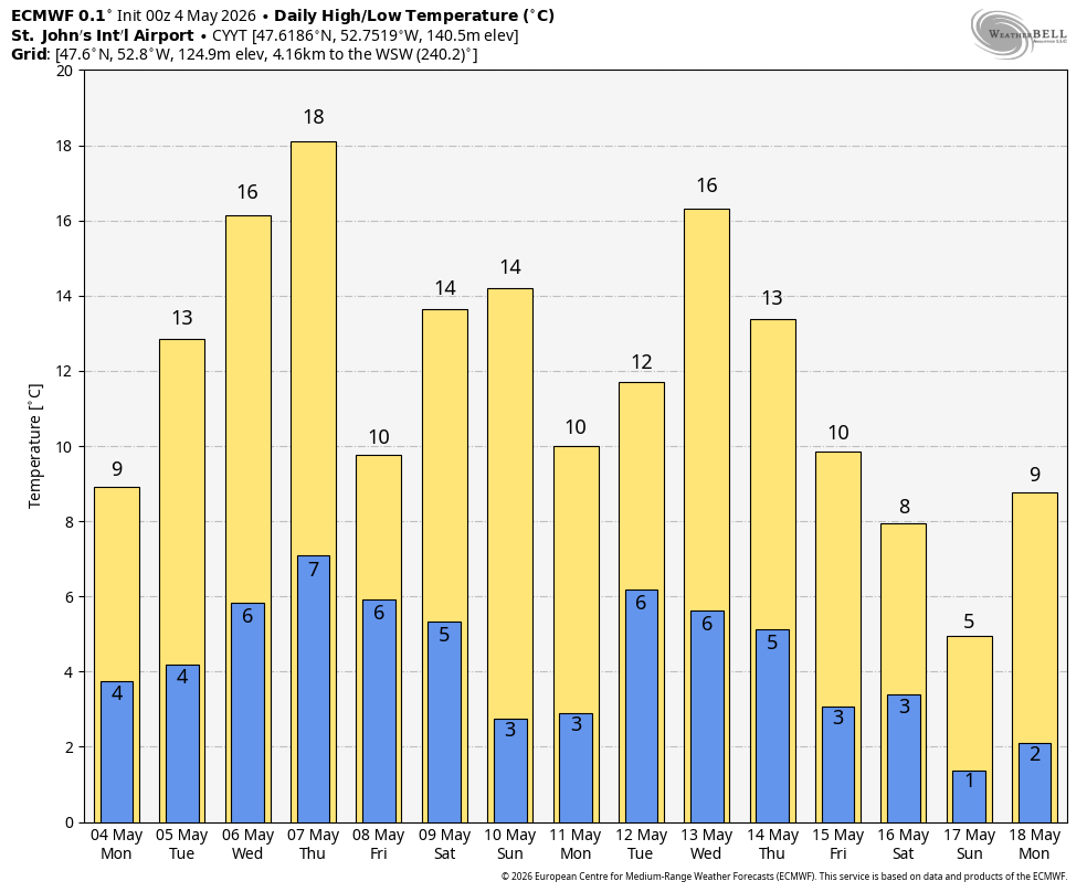
Expected high temperatures over the next few days for the St. John’s Metro area — other areas will be warmer!
I’ll have a full forecast posted later today!
📱 Get the Sheerr Weather App in the Apple App Store and Google Play Store.
🗺️ Check out the Map Room to see all the latest weather observations for the Province.
🎥 Check out the Provincial Highway Cams to see 👀 what’s going on around our highways and
By using this website, you agree to our use of cookies. We use cookies to provide you with a great experience and to help our website run effectively. Privacy Policy
Thanks Eddie
Good Morning Eddie! Looking forward to those higher temps… once today’s forecast moves out!
Thanks for update
Thanks for the update
Good morning and thanks Eddie for updating us
Good morning and Thanks for the update…