
Monday Morning’s Weather Briefing — March 2, 2026
This video shows what we can expect across NL for today — March 2, 2026
Good Monday Morning!
Here are today’s weather highlights:
Arctic air has returned to Labrador and will do the same over the Island today (if it hasn’t already).
Temperatures will be in the minus teens for much of Newfoundland today and even colder in Labrador. Wind chills will be substantially lower.
Yellow Level Extreme Cold Warnings are in effect for northern and western Labrador until midday today, for wind chills as low as -45ºC.
Yellow Level Snow Squall Watches are in effect for parts of western Newfoundland, the Burin Peninslula and southern areas of the Avalon from tonight until midday Tuesday.
Today’s Forecast – Brrrrrr
Arctic air returns to the Province today, setting the region up for the coldest day in a while. Temperatures this morning are already in the mid-teens in western Newfoundland and in the minus-teens and 20s in Labrador. Wind chills are into the minus teens and 20s on the Island and minus 30s and 40s in the Big Land. Temperatures in eastern areas will fall to the minus teens later this morning or early afternoon, matching those in the rest of the island today. Meanwhile, Labrador will stay in the mid-teens and 20s throughout the day. Wind speeds will be in the 20 to 30 km/h range, with gusts up to 60 km/h. (hourly temps + today’s temps below)
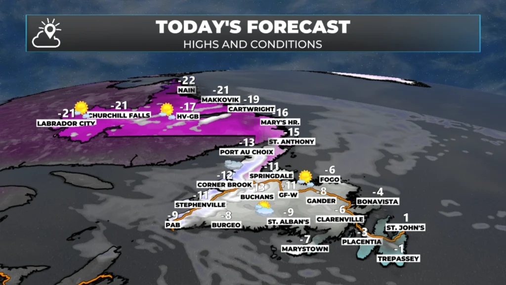
Today’s forecast for Newfoundland and Labrador – March 2, 2026
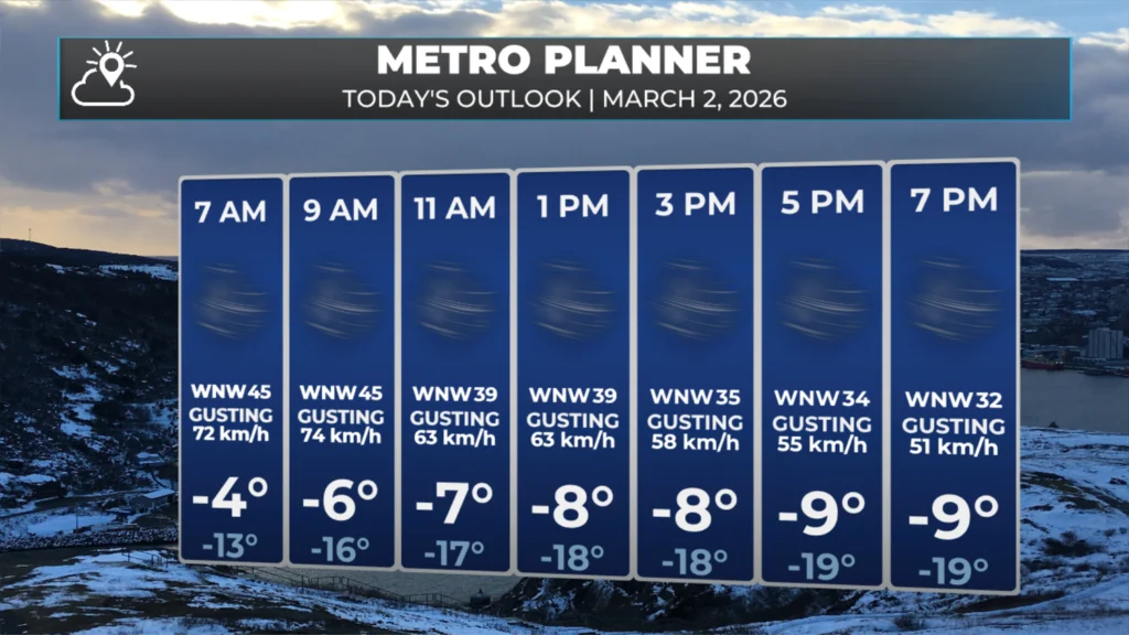
The Metro St. John’s area forecast for today – March 2, 2026
Expect a widespread mix of sun and cloud across the Province today. The exception will be over western areas of the Island and eventually southern areas, the Burin Peninsula and the southern Avalon where onshore snow flurries and/or squalls will set up shop this afternoon and evening. The squalls will be locally heavy and as mentioned above, Snow Squall Watchers are currently in effect. These will be upgraded to warnings at some point this evening or tonight by Environment Canada.
While snowfall amounts will not be heavy over large areas, locally significant accumulations will be found in areas that are under snow squalls or flurries for extended periods of time. This is most likely over the West Coast, the middle of the Burin Peninsula (think Garnish to Marystown) and southern areas of the Avalon. (snow amount map below)
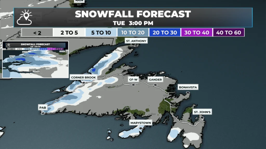
Sowfall forecast from this afternoon until Tuesday afternoon – March 2 – 3, 2026
Tuesday will see the flurries and squalls end, and warmer air moving in. That being said, highs will still be in the minus single digits over much of the Island and minus teens in Labrador… with lower wind chills. Outside of the flurries, expect a mix of sun and cloud across the Province. (Tuesday forecast here)
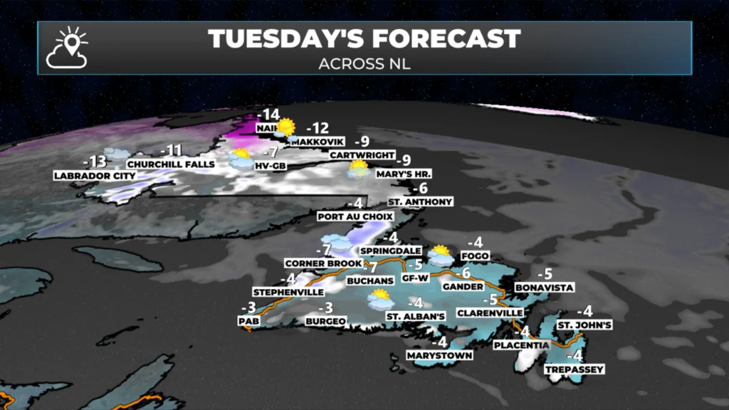
Tuesday’s forecast for Newfoundland and Labrador – March 3, 2026
A fast-moving low will bring a round of snow and mixed precipitation to the Island and parts of Labrador from Wednesday morning into Wednesday evening. Snowfall amounts don’t look significant, but a widespread 5 to 15 cm does appear likely, and includes the Avlaon Peniunsluua and Metro area. (WED SNOW BLEOW)
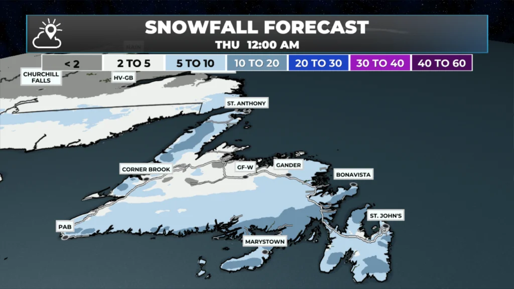
Snowfall forecast from Wednesday morning until Wednesday evening – March 4, 2026
Thereafter… the weather looks, dare I say, quiet for several days in a row… for now.
I’ll have updates for you throughout the day!
📱 Get the Sheerr Weather App in the Apple App Store and Google Play Store.
🗺️ Check out the Map Room to see all the latest weather observations for the Province.
🎥 Check out the Provincial Highway Cams to see 👀 what’s going on around our highways and
Good Monday ☕️ morning Eddie!
Thank you for the update!…Enjoy your day!..Stay safe!
Good morning Eddie, thanks for the update. Have a great day.
Good morning Eddie thanks for the update and have a great day
Good morning Eddie, thanks for weather update.
Thanks Eddie
Thanks for the update Eddie ! Pretty chilly out there this morning! Have a great day 😊
Thanks Eddie for the weather update.You do a tremendous job.👍👍