
Monday Morning’s Weather Briefing — February 23, 2026
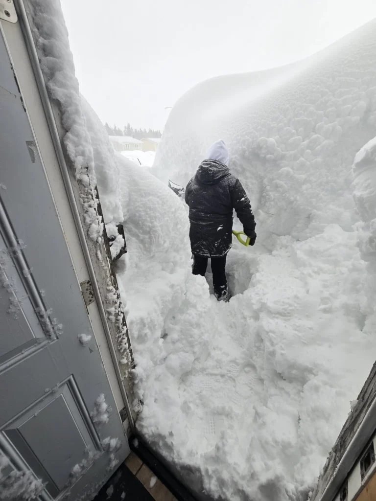
Credit: Karen Conway – Mount Pearl, NL – February 23, 2026
Good Monday Morning
Here are today’s weather highlights:
Our second major winter storm in less than a week ended last night, leaving a widespread 50 to 80 cm of snow over parts of the Avalon Peninsula, including the Metro area.
Many roads are closed across the region this morning, and your best sources for that info are 511NL.caand the City of St. John’s Facebook page. Another great resource for up-to-date information is the Newfoundland Bulletin Facebook Page.
The weather across the region will be calmer today, another system arrives tonight and will bring snow, rain and wind to NL between tonight and tomorrow
Eastern areas will see a period of snow tonight, 5 to 15 cm, followed by a change to rain Tuesday morning, then a brief warm-up to 5º, followed by an afternoon cool-down. Even with 5 to 10 mm of rain in the forecast, the snow will absorb much of that, and in my opinion, widespread flooding from this event isn’t a concern. However, the freeze-thaw-freeze cycle will freeze any standing snow into solid ice, so whatever you need to clean up, today is a good day to do that.
Yellow Level Winter Storm Warnings are in effect for southern Newfondland, Green Bay – White Bay, the Northern Peninsula and southeast Labrador. The alerts in the south are in effect from tonight into Tuesday morning, and the northern alerts are in effect from later tonight until Tuesday evening. Snowfall amounts will be 15 to 20 cm in most warned areas.
Keep in mind areas outside of these alerts will also see winter weather, and snowfall amounts are expected to remain below warning criteria.
I expect we will see wind warnings expanded to much of eastern Newfoundland for Tuesday, as high winds will accompany this system’s passage.
A Yellow Level Wreckhouse Wind Warning is in effect from this evening until Tuesday morning, for southeasterly gusts to 100 km/h.
Today’s Outlook
The forecast across Newfoundland and Labrador today is a quiet one as we await the arrival of our next weather maker. Clouds will be decreasing throughout the day, and wind speeds will generally be on the lighter side. Highs will be near freezing in eastern Newfoundland to a few degrees below in the west and north, and well below in Labrador.
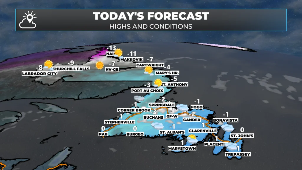
NL’s forecast for today — February 23, 2026
The storm system in the northeast will roll in overnight and bring another round of snow, rain and wind to Newfoundland and Labrador. Eastern areas will see the snow arrive overnight, and it will last for a couple hours before a change to rain early Tuesday morning. Central and western areas will see the snow longer, or for the duration of this event. Unlike the last couple fo lows, this is a fast mover so snowfall amounts across the region wil be light to moderate. The animation below shows how the radar will look as this moves in, and what the snowfall totals will look like.
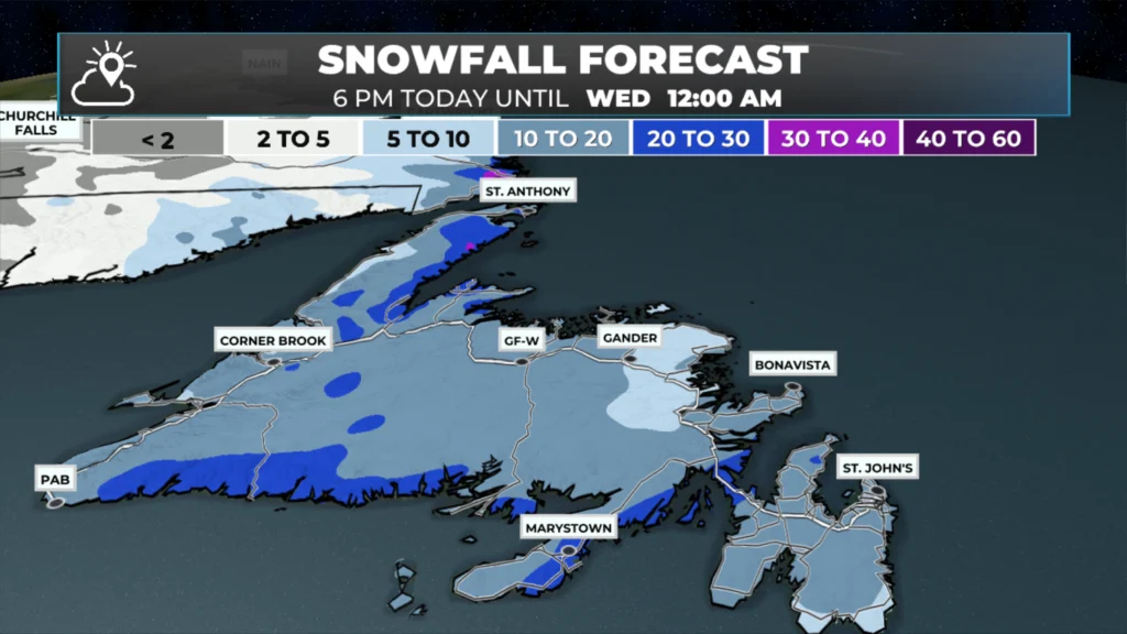
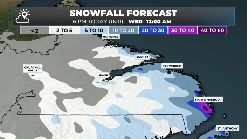
Southeastern and eastern regions, including the Avalon, will see rain after the snow. Look for5 to 15 mm of rain after the snow. The weather will improve Tuesday night and Wednesday… before our. next low moves in.. which looks to bring more snow to eastern regions and the Avalon.
I’ll have updates for you throughout the day!
📱 Get the Sheerr Weather App in the Apple App Store and Google Play Store.
🗺️ Check out the Map Room to see all the latest weather observations for the Province.
🎥 Check out the Provincial Highway Cams to see 👀 what’s going on around our highways and
The snow in that photo you shared is just brutal. Stay safe when doing snow removal everyone. Thank you Eddie!!
Thanks! It is crazy!
Good Morning Eddie!
I guess you’re just as frustrated with the weather as we are. You hinted about another system later in the week …… that’s worrisome!
I appreciate your time and effort keeping us updated around the clock. Have a good day!!
Good morning Eddie, thanks for weather update.
Thank you Eddie for the updates. Stay safe and keep your precious little girls safe. Have a good.💖💖💖
Thanks Eddie it great you got a little rest, thanks for the update
Good job Eddie! Keep up the good work. Found your video on cleaning out ice and snow for a mini-split, very helpful thanks for posting it.
First it rained, then it blew, then it friz, then it snew. A mixed bag of weather. Aren’t you glad you came to NL? Thank you for your updates. 😳😳
Thanks Eddie for the update….
Thank you Eddy for the update really appreciate .
Thank you Eddie for all the updates.You do a great job👍👍
Thanks Eddie for the update
Thank you Eddie, you’re the best!
Thanks for all your work Eddie, you are so very appreciated!!
Any word on why the eastern NL weather radar is down?