Monday Morning’s Weather Briefing — April 20, 2026
By Eddie Sheerr·
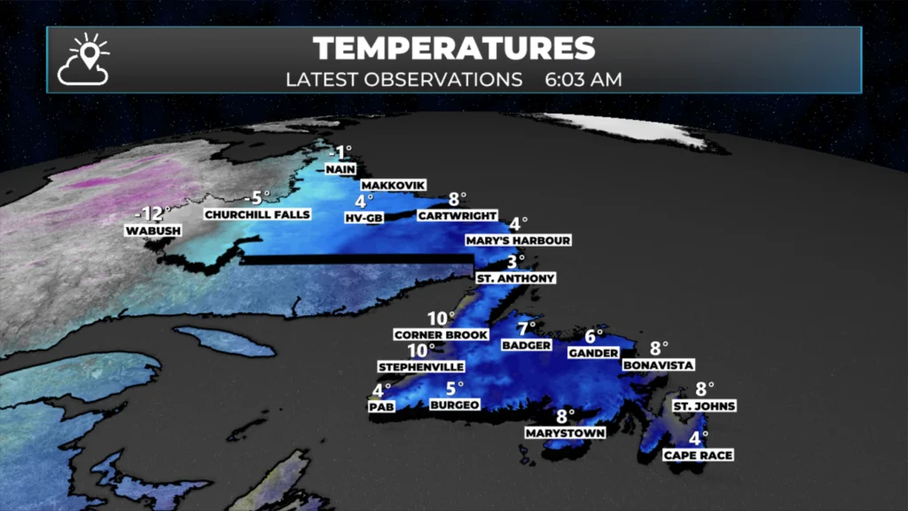
Temperatures across NL as of 6 AM NDT on April 20, 2026.
Good Monday morning!
Here are today’s weather highlights:
Showers and numerous across the Island this morning, but it’s mild. As of 6 AM, it’s nearly 8º in St. John’s!
A cold front will bring rain and snow to Labrador today, with some minor accumulations possible in the west.
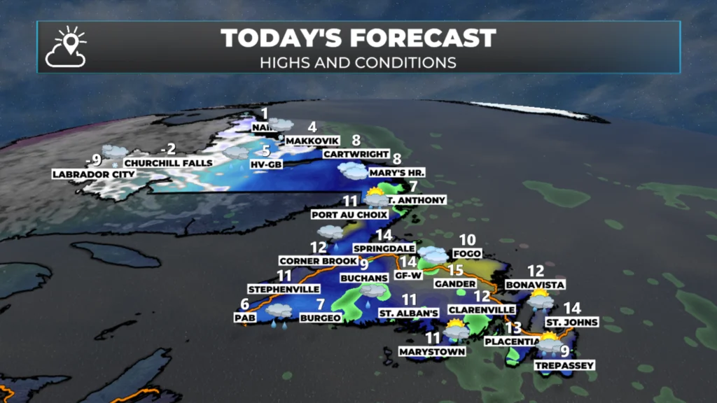
An unusually warm day will be found over eastern Labrador and much of Newfoundland — parts of the Island will reach the mid to upper teens this afternoon. Scattered showers and pockets of rain will be found on the Island in southerly flow.
The warmth is short-lived, as cold air returns tonight and Tuesday, setting the stage for a late-season winter storm across much of the Island.
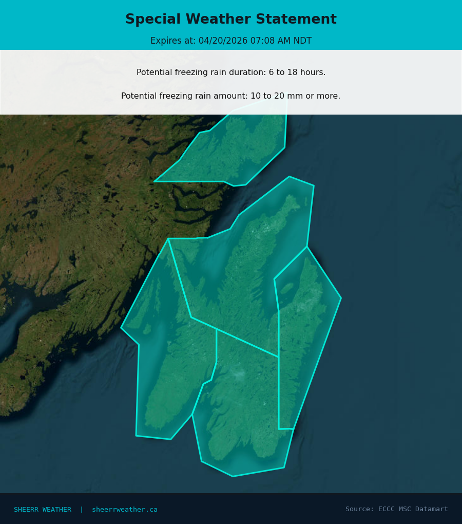
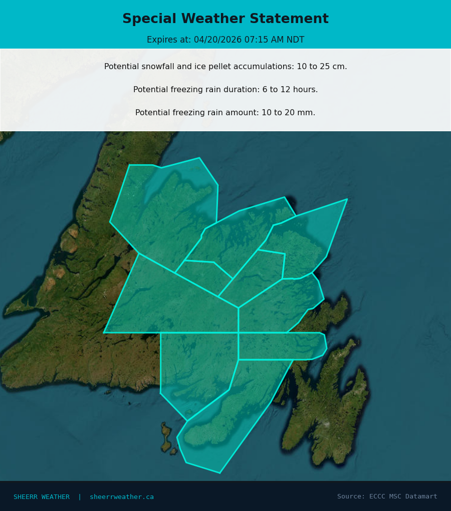
Special weather Statements are currently in effect for eastern, central and northeastern Newfoundland from Tuesday into the late Wednesday or Thursday time frame due to the threat of significant freezing rain and snow. The snow will be west of the Avalon.
Sponsored
Labrador’s Turn for Unsettled Weather
A cold front is on the move across Labrador today, and it’s bringing a messy mix of precipitation with it. Rain will be the dominant precipitation type across much of the region, but as colder air wraps in behind the front, western Labrador will see a changeover to snow through the day.
Don’t expect major accumulations — we’re talking minor snow totals in western areas, likely in the 2 to 5 cm range by this evening. The transition zone between rain and snow will shift eastward as the day progresses, so central Labrador could see a brief period of wet snow before things taper off tonight. Eastern Labrador and the coast should stay mostly rain throughout the day.
Unseasonably Warm Before the Fall
Today’s forecast for Newfoundland & Labrador. April 20, 2026.
Today is shaping up to be an unusually warm April day across eastern Labrador and much of Newfoundland. We’re talking mid to upper teens across large swaths of the Island this afternoon — temperatures you’d typically expect in early June, not late April.
The Avalon Peninsula, Burin Peninsula, and the eastern coastline should see highs climbing into the 14°C to 17°C range. Central Newfoundland won’t be far behind, with temperatures pushing into the low to mid-teens. Even areas that typically stay cooler due to onshore flow should manage to crack double digits today.
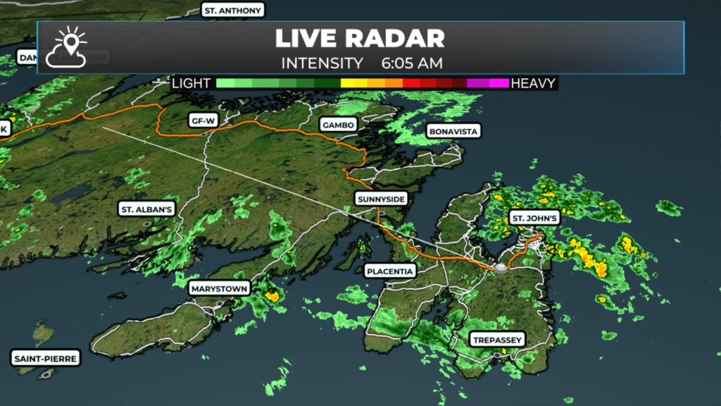
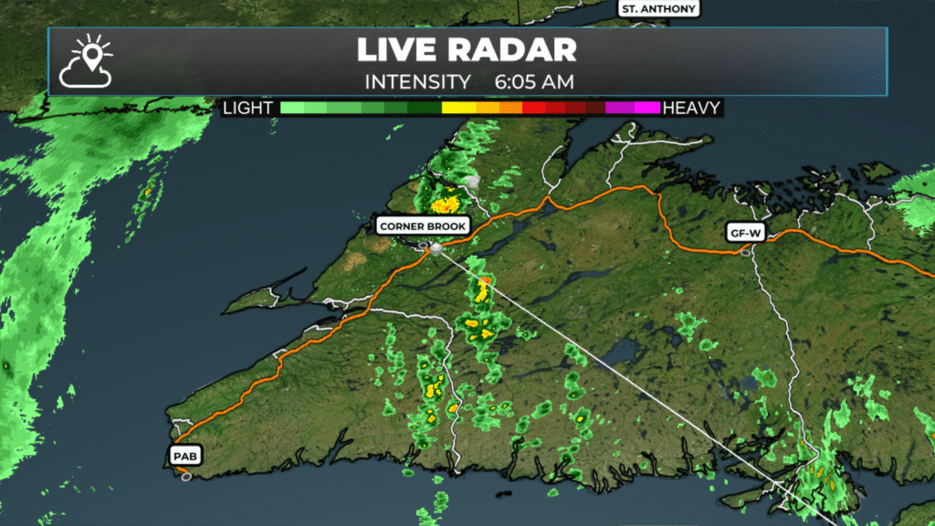
I wish I could say pure sunshine was going to accompany the warmth, but that will not be the case. While there may be some break of sun here and there, clouds will be the rule and showers will be numerous. Morning radar shows this quite well.
What’s driving this warmth? Strong southerly flow ahead of an approaching low pressure system is pumping mild air northward from the Atlantic. While this system is kind of our friend today, you will not feel the same way in about 24 hours…
Cold Air Crashes the Party
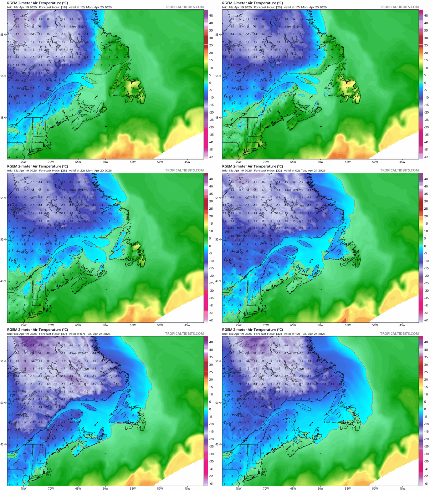
Enjoy the warmth while it lasts, because it’s extremely short-lived. Cold air will come crashing back into the region tonight and continue into Tuesday as a much different airmass takes hold. Temperatures will drop sharply overnight, and by Tuesday morning, we’ll be back to near or below freezing across much of Newfoundland. The temperature swing will be dramatic in some areas — we could see a 15°C drop in less than 24 hours in some communities. That’s the kind of whiplash that defines spring weather in Newfoundland and Labrador. This cold air return isn’t just uncomfortable — it’s setting the stage for what comes next.
Watch the cold air move across the region between this morning and Tuesday morning.
Late-Season Winter Storm on the Horizon
Special Weather Statements are currently in effect for eastern, central, and northeastern Newfoundland, and they’re worth paying close attention to. A significant late-season winter storm is taking shape and will impact much of the Island from Tuesday into the late Wednesday or Thursday timeframe. The big concerns are significant freezing rain and snow, with the exact mix depending on where you are.
Here’s the general breakdown: areas west of the Avalon Peninsula — including central Newfoundland and parts of the northeast coast — are looking at the highest risk for substantial snow accumulations. This is where the coldest air will be entrenched, and the system will have plenty of moisture to work with.
The Avalon Peninsula and the Bonavista Peninsula face a different threat: freezing rain. This is often the worst-case scenario in terms of impacts. Freezing rain can make roads impassable, snap tree branches, and bring down power lines. Even small accumulations of ice can cause major disruptions, and early guidance suggests this could be a significant icing event for some communities.
The timing is still being refined, but the window of Tuesday into late Wednesday or Thursday means this system will be slow-moving and persistent. That’s not good news — it means prolonged exposure to whatever precipitation type you’re dealing with, whether that’s heavy snow or dangerous ice accumulation.
What You Need to Do
If you’re in the affected areas expecting significant freezing rain — and that’s much of eastern Newfoundland and the Avalon— today into tomorrow is the time to prepare for the potential of a power outage. While I don’t expect it to be widespread, I do think there will be a few based on the forecast for freezing rain.
For those in the snow zone, get your shovels ready and plan for difficult driving conditions. For those in the freezing rain zone, be prepared for potential power outages and extremely hazardous road conditions. Freezing rain is deceptive — it doesn’t look like much is happening, but the ice builds up fast.
I’ll have much more detailed information on snowfall and ice accumulation amounts in this afternoon’s update. Keep checking back for updates as model guidance continues to refine the track and intensity of this system.
For now, enjoy today’s unusual warmth — but don’t be lulled into thinking winter is over. April in Newfoundland and Labrador has a long history of reminding us that the season doesn’t end until it’s good and ready.
Good Morning Eddie….. you’re back, and so is our inclement weather. Freezing rain!!! YIKES!! Another SHUT-IN day coming our way. Anyway, it’s good to have you back. Thanks for update!
⚠ Storm ModeGet warnings pushed to your phone the moment they’re issued.Get the app
By using this website, you agree to our use of cookies. We use cookies to provide you with a great experience and to help our website run effectively. Privacy Policy


The weather is being manipulated. All day yesterday they were spraying our skies with chemicals. When it’s a clear sky, look up. They are lying to us.
Who is "they" ?
Good morning Eddie, thanks for the update. Have a great day.
Good Morning Eddie….. you’re back, and so is our inclement weather. Freezing rain!!! YIKES!!
Another SHUT-IN day coming our way. Anyway, it’s good to have you back. Thanks for update!
Good morning Eddie and welcome back, thanks for keeping us updated
Good morning Eddie, welcome back! Hope you had a great holiday . Thanks for the update have a great day 😊
I love how you put the weather report together Eddie. Plain and simple, but you get it across and people get prepared.
Thanks Eddie. Tracking this for potential flight disruptions for Thursday morning!