
Monday Morning Weather Briefing — July 27, 2026
Good Monday Morning! Here are some highlights on the day(s) ahead:
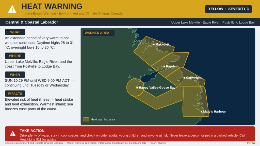
A Heat Warning remains in effect for central and eastern Labrador until tomorrow or Wednesday for highs near 30ºC and lows in the upper teens.
A cooler pattern has established itself over eastern Newfoundland, while central and western areas are still very much in the heat for today.
Fog becomes more widespread on the eastern, southern and northeastern facing shores overnight and Tuesday as a weak area of low pressure moves in from the south.
This morning’s update is sponsored by Roebothan, McKay, Marshall.

Visit MakeTheCall.ca today to learn more about how the law firm can help you!
Sunday was a scorcher for a lot of us. Stephenville hit 27.7°C, breaking a record that stood since 1940, and Labrador really took it up a notch — Cartwright tied its 1970 record at 32.8°C, Makkovik set a new one at 31.5°C, and Mary’s Harbour hit 32.6°C.
Hot Sunday! 🔥
— Rodney Barney (@rcbstormpost) July 27, 2026
33.1°C Goose B #YYR (2nd highest in 2026);
32.8°C Cartwright (warmest s/Aug 13, '25);
32.6°C Mary's Hr (warmest s/Aug 11, '25);
30.2°C Badger (first 30+°C & warmest s/Aug 13, '25);
27.8°C Sagona I (warmest s/all-time rec 28.3°C on Jun 11, '07!). Data s/1994. #nlwx pic.twitter.com/yADYUMePm7
That heat hasn’t let go of Labrador yet, which is why the Heat Warning is still up this morning for Upper Lake Melville, Eagle River, Postville-Makkovik, Norman Bay to Lodge Bay, Cartwright to Black Tickle, and Rigolet and vicinity. Daytime highs of 28 to 31 and overnight lows of 16 to 20 continue into Tuesday or Wednesday. Coastal spots should catch a break first as afternoon sea breezes kick in tonight into Tuesday, but if you’re inland — especially around Upper Lake Melville — expect the heat to hang on right through Wednesday evening.
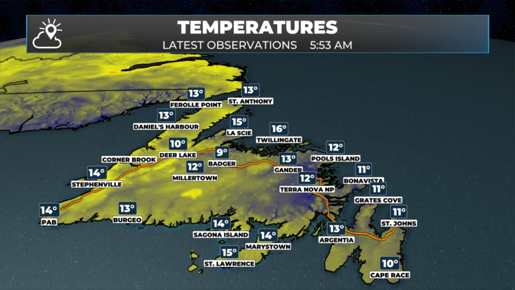
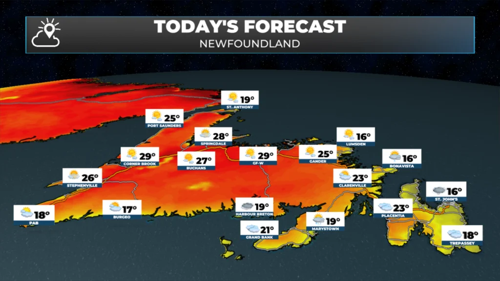
Meanwhile the Island woke up in a completely different world this morning. St. John’s is sitting at 12°C with cloud and patchy fog knocking visibility down to a couple of kilometres, and that onshore flow is going to keep the Avalon on the cool side all day. Head west, though, and it’s a different story — Corner Brook is looking at highs near 29°C today. That’s about as big a temperature split as you’ll see across the Island on a single day, and it comes down to which side of the province is catching the onshore wind versus which side isn’t.
Eastern Newfoundland and the Avalon are stuck under cloud today, with highs only in the mid-teens, 14 to 17, and a slight chance of a shower. Fog and drizzle patches are likely to build back in tonight along the Southern Shore and other east- and south-facing stretches, lingering into Tuesday morning — worth knowing about if you’re on the road early.
Central is warmer and mostly sunny, with highs climbing to the low-to-mid 20s, around 22 to 26.
The West Coast is the warm spot on the Island today, with highs from 25 to 29 — warmest up through the Humber Valley and Bay of Islands, a touch cooler if you’re up over the Long Range highlands.
The South Coast sits in the high teens, 17 to 19, under mostly cloudy skies with just a slight chance of a shower.
Southwest and Wreckhouse are also in the high teens, 17 to 19, with a brisker onshore wind out of the southeast — nothing warning-worthy, but noticeable if you’re driving through.
The Northern Peninsula and the Straits see a mix of sun and cloud with highs in the high teens, 17 to 20.
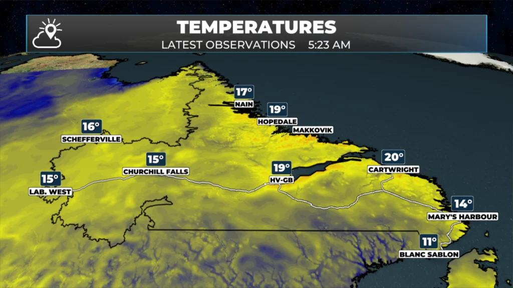
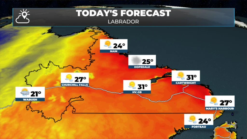
Labrador is a study in contrasts today and we can already see that relfected in temperatures this morning. Goose Bay is already near 20ºC while Mary’s Harbour is at 14ºC.
The coast around Nain is mixed sun and cloud with highs in the low-to-mid 20s. Central Labrador, around Goose Bay, stays hot and mostly sunny with highs near 31 — right in the thick of the Heat Warning. But out in Labrador West, around Lab City, the story flips: showers and even a rumble of thunder are expected this morning with highs only near 21, so if you’re out that way, keep an eye on the sky.
Looking ahead, this quiet, warm pattern isn’t locked in forever. There’s a system organizing over the Great Lakes and the northeastern US that could eventually send a cold front our way later this week, though the timing’s still fuzzy — one to watch rather than plan around just yet. On the tropical side, nothing is brewing in the Atlantic over the next week, so no worries there for now.
I’ll have an updated forecast for the remainder of the week posted later today!
My next update will be posted later today!
📱 Get the Sheerr Weather App in the Apple App Store and Google Play Store.
🗺️ Check out the Map Room to see all the latest weather observations for the Province.
🎥 Check out the Provincial Highway Cams to see 👀 what’s going on around our highways and
Good Morning Eddie
I’ve enjoyed the warm, sunny days, looks as though that’s coming to an end, at least for the rest of this week in our area. Thanks for the
update. Enjoy your day!
Good morning Eddie have a wonderful day and thanks for the update
Good morning, Eddie! Thanks for the forecast! Have a great day!
Good morning Eddie, thanks for the update. Have a great day.