
Monday Morning Weather Briefing — April 13, 2026
Good Monday morning!
Here are today’s weather highlights:
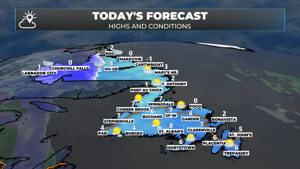
As yesterday’s system departs, a narrow area of high pressure will set up shop over Newfoundland, bringing a calmer and generally sunny day.
Another area of low pressure will move into Labrador, bringing another round of snow. Snow arrives this morning in the west, and later today on the coast and in the Straits.
That same system will move across Newfoundland tonight and will bring some snow with it. The snow will end as rain on the southern Avalon and Burin Peninsulas.
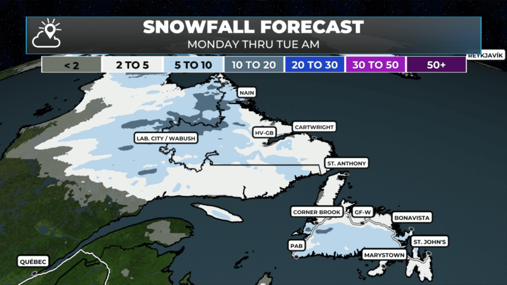
Most areas will see 5 to 10 cm of snow between today and Tuesday morning.
Highs today will be near or above freezing for much of NL, and Tuesday will be similar. However, much colder air moves into Labrador on Tuesday afternoon.
Brief Calm Before the Next System: Snow Returns Tonight
After yesterday’s active weather, Newfoundland is catching a brief breather today as a narrow ridge of high pressure slides into the region. This will bring a welcomed break from the unsettled conditions we’ve experienced recently, with mostly sunny skies and lighter winds prevailing across the island. It’s the calm before the next storm, so enjoy it while it lasts.
While Newfoundland gets a temporary reprieve, Labrador won’t be as fortunate. Another area of low pressure is already on the move, tracking into western and central Labrador this morning. This system will bring a fresh round of snow to the Big Land, with accumulations beginning early today in western regions. The snow will gradually spread eastward throughout the day, reaching the Labrador coast and the Straits of Belle Isle by late this afternoon and early evening.
The same system responsible for Labrador’s snow will continue its eastward trek and cross Newfoundland overnight tonight into early Tuesday morning. As it does, it will bring another round of accumulating snow to most of the island. However, the southern Avalon Peninsula and Burin Peninsula will see a transition scenario unfold. Thanks to milder air wrapping around the system, these areas will see the snow changeover to rain before tapering off early Tuesday. This mixed bag means less total accumulation for these southern regions, but potentially slick conditions during the transition period.
Snowfall Accumulations
Most areas across Newfoundland and Labrador can expect between 5 and 10 cm of snow from this system between today and Tuesday morning. Western and central Labrador will see the bulk of their accumulation through this afternoon and evening, while the island will see most of its snow fall overnight tonight. As mentioned, the southern Avalon and Burin Peninsula will see lower totals due to the changeover to rain.
Temperature Outlook
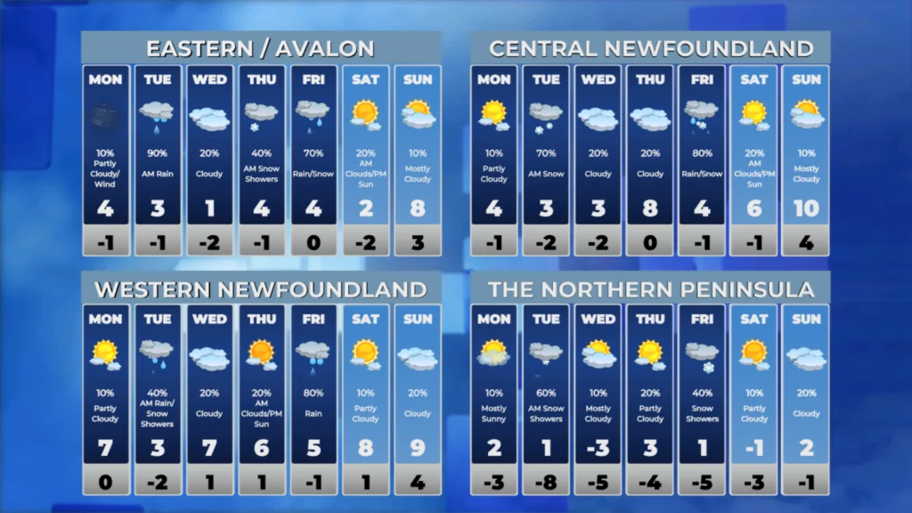
Despite the snow in the forecast, temperatures will remain relatively mild for mid-April. Highs today will hover near or just above the freezing mark across much of Newfoundland and Labrador. Tuesday will follow a similar pattern for the island, with temperatures again reaching near 0°C or slightly higher in most regions.
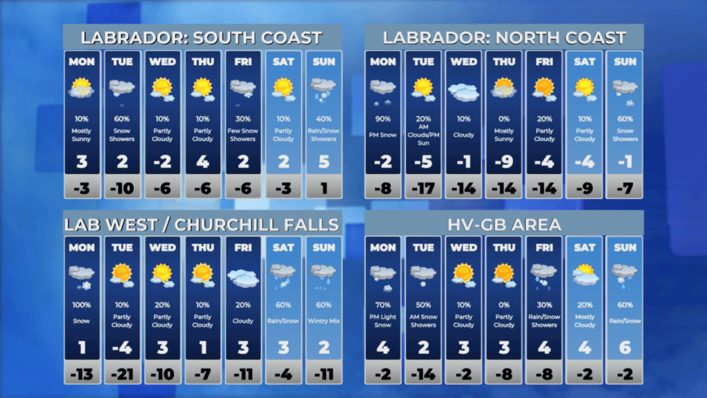
However, Labrador is in for a dramatic change Tuesday afternoon. Much colder air will punch into the region on northwest winds behind the departing low pressure system, sending temperatures tumbling well below seasonal norms. This Arctic air mass will bring a harsh end to the relatively mild conditions, so residents in Labrador should prepare for a significant temperature drop..
📱 Get the Sheerr Weather App in the Apple App Store and Google Play Store.
🗺️ Check out the Map Room to see all the latest weather observations for the Province.
🎥 Check out the Provincial Highway Cams to see 👀 what’s going on around our highways and
Good Morning Eddie. The temps are struggling to rise
Thanks for update
Thank you.
Morning Eddie and thanks for the update
Thanks for the update Eddie …Enjoy your day 🙂