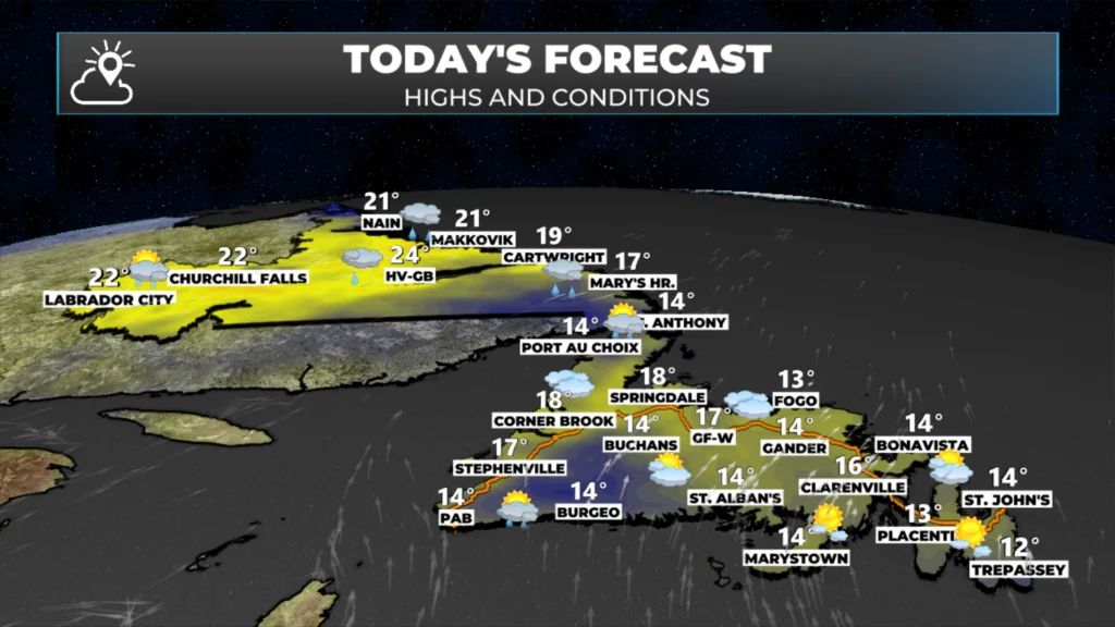
Unseasonably warm temperatures will be found across much of NL today, then the warmth will primarily be focused on the Island Tuesday and Wednesday — we are talking teens and 20s.
Scattered showers move across parts of Labrador and northwestern Newfoundland today as a warm front passes through.
A cold front begins to sweep through Labrador on Tuesday, but it will take until Thursday for it to clear the entirety of NL.
Areas west of Happy Valley-Goose Bay may see some wet snow on Wednesday night and Thursday
Potential is growing for significant rain across much of the Island late Wedenesday and Thursday
This morning’s update is sponsored by Roebothan, McKay, and Marshall.
Sponsored
Visit MakeTheCall.ca to learn more about what the law firm can do for you.
We are beginning the day with temperatures in the two different worlds across the Province. On the Island, multiple areas are within a couple degrees of freezing (on either side of the goose egg); meanwhile, in Labrador, temperatures are already into the teens in the west as of 5:07 AM ADT!
Across the Province today, we will see a mix of sunshine and cloud cover. As the warm front moves through, scattered showers will accompany it. The highest chance for showers for southeast Labrador, the GNP, and the West Coast will be this morning into the early afternoon, with central, southern, and eastern areas seeing a higher chance of a passing shower later this afternoon or this evening. Be sure to check the Sheerr Weather App’s hourly forecast to time out your day! Temperatures reach the teens on the Island and teens to 20s in Labrador. I’d suspect some new daily record highs will be set today!
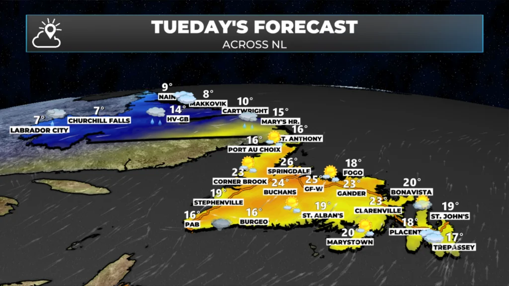
As the cold front begins to sweep across the region on Tuesday, temperatures in Labrador will start to plummet. Highs in the north and west tomorrow will be much cooler than today. Meanwhile, the warm air will hold on in the southeast and across the Island. You can see that nicely in the forecast high temperatures and conditions for tomorrow.
That cold air will sweep across the rest of NL as the week progresses, but it’s going to take its time. The animation below shows the cold air (blue) eventually overwhelming the weather pattern. If you’re a lover of summer temperatures, I suggest soaking in the next two days, because after this, you may have to travel a considerable distance south to see temperatures in the teens and 20s, unless you’re willing to wait until next spring.
Tropical Update
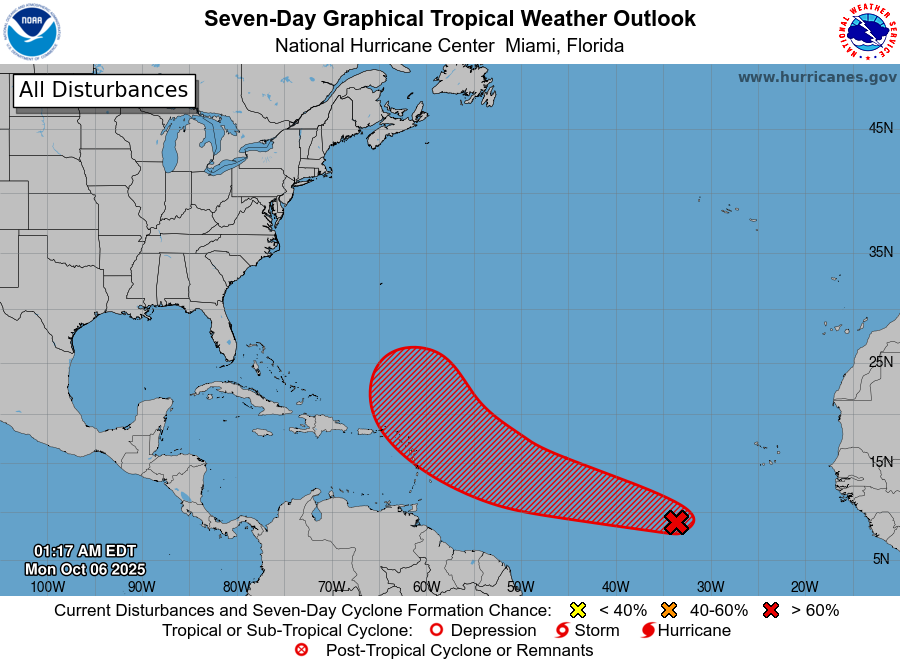
The US NOAA National Hurricane Center, based in Miami, Florida, is currently watching an area of development that has a 70% chance of becoming a tropical cyclone within the next 5 days. Otherwise, the tropical Atlantic is quiet for the time being.
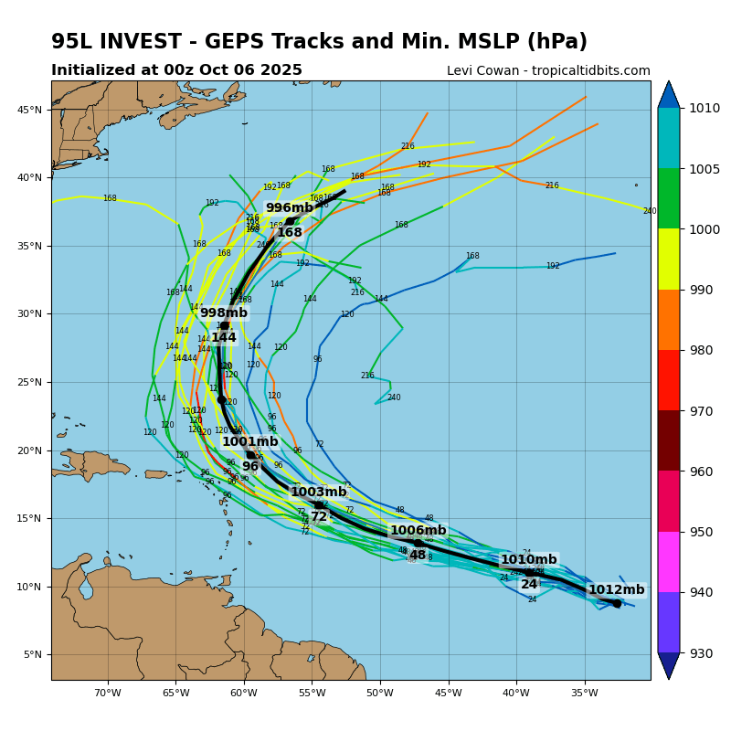
Forecasts indicate that this system, currently designated as 95L, will likely become a tropical storm within the next couple of days and possibly a hurricane by the middle or end of this week. The name of this next tropical cyclone will be Jerry. The current forecast also indicates that this next tropical system will likely stay north of the Lesser Antilles and the Caribbean Sea. Updates to follow!
Forecast tracks (spaghetti chart) for the upcoming tropical system in the Atlantic Ocean.
Have a great Monday! My next update will be posted this afternoon!
⚠ Storm ModeGet warnings pushed to your phone the moment they’re issued.Get the app
By using this website, you agree to our use of cookies. We use cookies to provide you with a great experience and to help our website run effectively. Privacy Policy


Thank you, sir.
Thanks Eddie!
Happy Monday Eddie, thank you
Thank you Eddie!
Sure enjoying your app! I check into it several times each day 👌
Thanks Eddie
Love the app!
☺️
Thanks Eddie!🍁🍂🌞
Good morning Eddie and thanks for the update
Best weather forecast I’ve ever had thanks so much for creating this site